Executive Overview
The American Southwest faces an existential hydrological emergency as Lake Mead and Lake Powell—the nation’s two largest man-made reservoirs—simultaneously plummeted to their lowest water levels in recorded history. Situated along the spine of the Colorado River system, these interconnected basins serve as the critical water bank for roughly 40 million people across seven U.S. states and Mexico, while irrigating more than 5.5 million acres (22,258 square kilometers) of highly productive agricultural land.
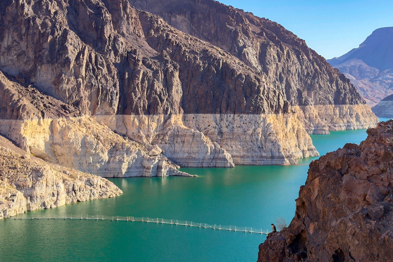
Within days of each other, both reservoirs shattered prior record lows, signaling that a quarter-century of unrelenting "megadrought" has crossed into a permanent state of climate-driven aridification. Lake Mead, retained by the iconic Hoover Dam, registered a historic low elevation on August 7, only to be followed on August 15 by Lake Powell, impounded by Glen Canyon Dam, which breached its own lower threshold.
This dual collapse highlights a multi-decade divergence between water availability and human demand. While the combined storage capacity of Lakes Mead and Powell stands at an impressive 68 cubic kilometers (approximately 55 million acre-feet)—a volume theoretically sufficient to cover total household consumption across the contiguous United States for nearly 18 months—the reservoirs now hold only a fraction of their capacity. Scientists, water managers, and policymakers warn that without aggressive, structural reductions in water allocations, the system risks approaching "minimum power pool" status—where hydroelectric generation ceases—and eventually "dead pool," where water can no longer pass downstream through dam outlets.
The crisis is driven by three intersecting pressures: rising global temperatures that deplete mountain snowpacks, explosive population growth across Southwestern urban centers, and a legal architecture—anchored by the century-old Colorado River Compact—that systematically over-allocated the river’s average flow.
Detailed Chronology of the Crisis
========================================================================================
TIMELINE OF THE COLORADO RIVER SYSTEMIC DECLINE
========================================================================================
1922          Colorado River Compact signed, over-estimating average annual flows.
1935          Hoover Dam begins impounding Lake Mead; filling phase commences.
1963          Glen Canyon Dam completed; Lake Powell begins filling.
1980s         Peak modern capacity reached; Lake Powell fills to maximum capacity.
1992–Present  Basin population relying on Colorado River rises by 15 million (+60%).
2000          Beginning of the multi-decadal Southwestern "Megadrought."
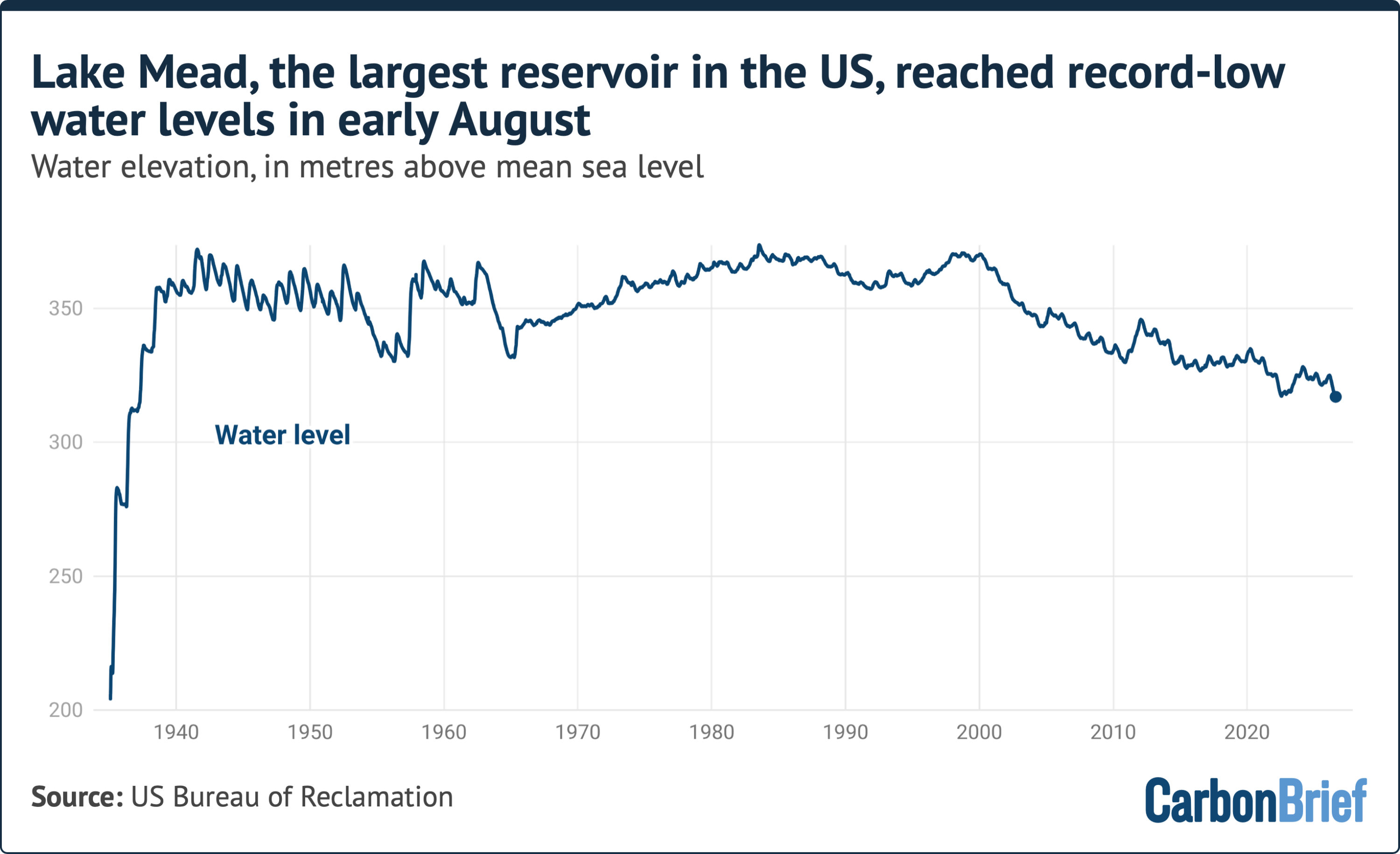
Aug 7         Lake Mead hits unprecedented historical low elevation of 317.11 meters.
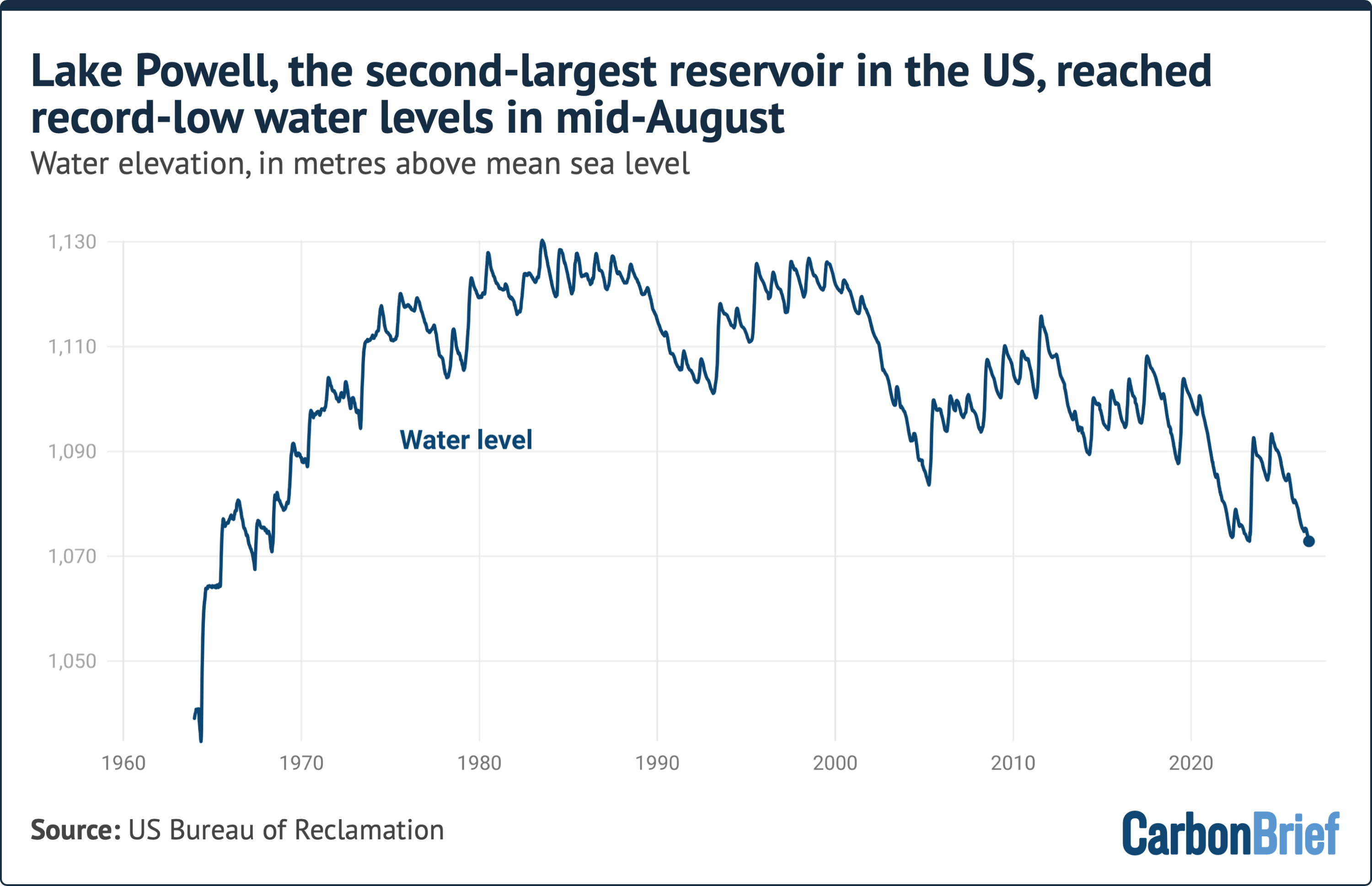
Aug 15        Lake Powell reaches new historic low elevation of 1,072.87 meters.
July 31       Bureau of Reclamation issues draft EIS for post-2026 operations.
April (Next)  Expected seasonal end of annual reservoir drawdown before snowmelt.
========================================================================================
The August Record Lows
The current escalation reached a threshold in early August. On August 7, sensors at Lake Mead recorded a surface elevation of 317.11 meters (1,040.4 feet) above mean sea level. This broke the reservoir’s previous low, marking a decline of over 30 meters from its "full pool" elevation of 347.60 meters (1,140.4 feet).
Just eight days later, on August 15, Lake Powell—located roughly 300 miles upstream—followed suit. Water levels dropped to a unprecedented low of 1,072.87 meters (3,520.0 feet) above mean sea level. Lake Powell’s full pool maximum stands at 1,127.76 meters (3,700 feet). The reservoir, which achieved capacity several times during the high-runoff years of the 1980s, has not approached full capacity in more than two decades.
Seasonal Dynamics and Drawdown Trajectory
The timing of these record lows is particularly concerning to hydrologists. Peak runoff in the Colorado River Basin typically occurs in late spring and early summer, driven by the melting snowpack of the Rocky Mountains in Colorado, Utah, and Wyoming. By August, this seasonal inflow declines sharply, while agricultural and municipal diversions peak during the hot late-summer months.
Consequently, water levels in both reservoirs are projected to continue their downward trajectory through the autumn and winter. The decline will persist unabated until roughly April of next year, when the subsequent spring thaw initiates the next potential recharge cycle. Hydrologists emphasize that because winter snowpack yields have become increasingly unreliable due to warmer soil temperatures and atmospheric dryness, there is no guarantee that the spring of next year will deliver sufficient runoff to offset the winter losses.
Supporting Context, Metrics, and Systemic Drivers
+----------------------------------------------------------------------------------+
|                   COLORADO RIVER BASIN: CORE METRICS AT A GLANCE                 |
+----------------------------------------------------------------------------------+
| Total Population Dependent on River:      ~40 Million People                     |
| Population Growth (Since 1992):            +15 Million (+60%)                    |
| Agricultural Land Irrigated:              5.5 Million Acres (22,258 sq km)       |
| Combined Reservoir Capacity (Full Pool):  68 km³ (~55 Million Acre-Feet)         |
| Upper Basin Flow Reduction (1900–Present): ~20% Drop                             |
| Flow Loss Attributable to Climate Change:  ~50% of Total Reduction               |
| Megadrought Intensity Attributable to CC: ~47% (2000–2018 Study Period)         |
+----------------------------------------------------------------------------------+
The Hydrological Collapse: Capacity vs. Realized Storage
The scale of the deficit becomes clear when contrasting the current state of Lakes Mead and Powell against their design capacities:
LAKE MEAD WATER ELEVATION (Meters Above Sea Level)
Full Pool:    [347.60 m]  ====================================================== 100%
Current Level:[317.11 m]  ========================= [CRITICAL DEFICIT]

LAKE POWELL WATER ELEVATION (Meters Above Sea Level)
Full Pool:    [1127.76 m] ====================================================== 100%
Current Level:[1072.87 m] ========================= [CRITICAL DEFICIT]
At design capacity, the 68 cubic kilometers of water held by the two lakes represents one of the most sophisticated water storage networks in the world, designed to cushion the arid Southwest against multi-year dry spells. However, continuous over-drafting combined with reduced basin runoff has depleted this emergency reserve to less than one-third of total capacity, creating a structural deficit where far more water is legally allocated and withdrawn each year than enters the system.
Climate-Driven Aridification vs. Demographic Growth
The collapse of the reservoirs is driven by a combination of natural and anthropogenic factors operating on both the supply and demand sides:
- Upper Basin Flow Reductions: Since the beginning of the 20th century, the average annual volume of water flowing through the Upper Colorado River Basin has decreased by approximately 20%. Peer-reviewed hydrological research indicates that roughly half of this overall decline is directly attributable to human-induced climate change. Warm temperatures cause winter precipitation to fall as rain rather than snow, accelerate early snowmelt, increase sublimation, and dry out mountain soils—which absorb moisture before it can reach river tributaries.
- The 25-Year Megadrought: The Southwest is currently experiencing its driest multi-decade period in over 1,200 years. Studies show that roughly 47% of the intensity of this ongoing megadrought is driven by atmospheric warming linked to greenhouse gas emissions.
- Explosive Population Growth: While water supplies have contracted, municipal demand has surged. Since 1992, the number of urban residents reliant on the Colorado River for drinking water, sanitation, and industrial use has grown by 15 million people—a 60% increase. Metropolises like Phoenix, Las Vegas, Los Angeles, San Diego, and Salt Lake City depend on trans-basin diversions fed by the river.
          ┌──────────────────────────────────────────────────────────┐
          │             DRIVERS OF THE SYSTEMIC DEFICIT              │
          └─────────────────────────────┬────────────────────────────┘
                                        │
             ┌──────────────────────────┴──────────────────────────┐
             ▼                                                     ▼
┌─────────────────────────┐                               ┌─────────────────────────┐
│   SUPPLY-SIDE DECAY     │                               │    DEMAND-SIDE SURGE    │
├─────────────────────────┤                               ├─────────────────────────┤
│ • 20% Upper Basin Flow  │                               │ • 15M New Residents     │
│   Reduction             │                               │   (+60% since 1992)     │
│ • 47% Megadrought Risk  │                               │ • 5.5M Acres of Water-  │
│   Climate-Driven        │                               │   Intensive Farmland    │
│ • Elevated Soil &       │                               │ • Archaic Legal Framework│
│   Atmospheric Absorption│                               │   (1922 Compact)        │
└─────────────────────────┘                               └─────────────────────────┘
Agricultural Demands and Hydroelectric Risks
Agriculture accounts for nearly 80% of all water diverted from the Colorado River Basin. The 5.5 million acres of farmland serviced by the system produce a large portion of North America’s winter vegetables—particularly in California’s Imperial Valley and Arizona’s Yuma County—alongside water-intensive forage crops like alfalfa and hay, which support domestic and international livestock markets.
Beyond food and drinking water, the drawdown threatens clean energy generation across the western power grid. Glen Canyon Dam (Lake Powell) and Hoover Dam (Lake Mead) generate billions of kilowatt-hours of hydroelectricity annually, powering millions of homes and providing critical grid-stabilization services.
- Minimum Power Pool at Lake Powell: 1,063.7 meters (3,490 feet). Below this point, water drops below the penstocks, disabling the generators and cutting off power to rural electric cooperatives across several states.
- Dead Pool Thresholds: If Lake Powell drops below 1,027 meters (3,370 feet), or Lake Mead drops below 272 meters (895 feet), water can no longer flow through the dams via gravity, severing downstream delivery to Arizona, California, Nevada, and Mexico.
Official Statements and Policy Interventions
Expert Analysis: Ultimate vs. Proximate Causes
The crisis highlights a fundamental mismatch between natural hydrological capacity and human governance structures. Speaking on the structural drivers of the crisis, Dr. Jack Schmidt, a senior research scientist at Utah State University’s Center for Colorado River Studies, delineated the core mechanics:
"There’s an ultimate cause of the present water crisis, and there’s a proximate cause. The ultimate cause is a warming climate, a warming planet and a pretty clear correlation between warming conditions and decreased runoff in the Colorado River Basin."
Dr. Schmidt further emphasized that political and administrative systems have struggled to keep pace with the speed of environmental change:
"The proximate cause is that in this messy democratic republic of ours, big policy decisions that match the variability of the climate occur painfully slowly—with intense political negotiations—and only incrementally."
Highlighting the uncertainty facing water managers as the region enters the autumn drawdown, Dr. Schmidt noted:
"The big dilemma of the moment is that we’re only in the middle of August, and we have no assurance of what the coming winter will be. The only thing we can be sure of is that we will be depleting overall total basin reservoir storage from now until, roughly, early April."
+----------------------------------------------------------------------------------+
|                     POLICY VS. CLIMATE IMPACT ANALYSIS                           |
+----------------------------------------------------------------------------------+
| ULTIMATE CAUSE    | Anthropogenic warming -> Reduced mountain snowpack,          |
|                   | increased evaporative demand, persistent dry soil conditions.|
+-------------------+--------------------------------------------------------------+
| PROXIMATE CAUSE   | Slower political and legal institutions -> Fragmented         |
|                   | negotiations, incremental cuts, reliance on outdated law.    |
+-------------------+--------------------------------------------------------------+
| NEAR-TERM THREAT  | Guaranteed depletion of basin-wide reserves through April,   |
|                   | with no winter snowpack guarantees.                          |
+----------------------------------------------------------------------------------+
Federal Response and the Post-2026 Guidelines
On July 31, the U.S. Bureau of Reclamation—the federal agency within the Department of the Interior responsible for managing water infrastructure across the West—released a key Environmental Impact Statement (EIS). This document provides the analytical framework for developing new operational rules for Lakes Powell and Mead after the current guidelines expire at the end of 2026.

While the comprehensive post-2026 operating strategy remains under negotiation among federal officials, seven basin states, and 30 federally recognized Native American tribes, the draft statement outlines potential federal interventions. Notably, it indicates that the federal government may reserve discretionary authority to issue mandatory cutbacks to state water allocations during severe system emergencies.
However, scientific reviewers caution that operational guidelines alone cannot compensate for structural climatic drying. As Dr. Schmidt observed regarding the federal framework:
"They acknowledge it won’t work if we just stay critically dry, and of course every climate model for the 21st century, especially with a continually warming planet, says that that’s exactly what’s going to happen."
Future Outlook and Structural Reform
The current operational rules, established under the 2007 Colorado River Interim Guidelines and supplemented by the 2019 Drought Contingency Plans, have proven insufficient to arrest the depletion of Lakes Mead and Powell. As stakeholders prepare for negotiations over the post-2026 management regime, several structural changes are under consideration:
+----------------------------------------------------------------------------------+
|                PROPOSED POST-2026 STRUCTURAL ADAPTATION STRATEGIES               |
+----------------------------------------------------------------------------------+
| 1. ACCOUNTING FOR EVAPORATIVE LOSSES                                             |
|    Enforcing mandatory cutbacks to account for ~1.5 million acre-feet of water       |
|    lost annually to evaporation and transit inefficiency in the Lower Basin.     |
+----------------------------------------------------------------------------------+
| 2. EXPANDED AGRICULTURAL FALLOWING & CROP SWITCHING                              |
|    Incentivizing farmers to transition from water-intensive crops (alfalfa)      |
|    to high-efficiency irrigation and drought-tolerant alternatives.              |
+----------------------------------------------------------------------------------+
| 3. URBAN WATER RECYCLING & TURF REMOVAL                                          |
|    Mandating large-scale wastewater recycling (e.g., direct potable reuse) and   |
|    prohibiting non-functional turf in municipal landscapes basin-wide.           |
+----------------------------------------------------------------------------------+
| 4. DYNAMIC OPERATIONAL TIERS BASED ON REAL-TIME HYDROLOGY                        |
|    Replacing rigid allocation schedules with dynamic reduction tiers indexed     |
|    directly to total system storage, accounting for climate trends.              |
+----------------------------------------------------------------------------------+
The Transition from Drought Management to Aridification Adaptation
Scientists increasingly reject the term "drought" to describe conditions in the Colorado River Basin. A drought implies a temporary climate anomaly that will eventually revert to a historic wet mean. Instead, climate projections unanimously point to continuous, long-term aridification—a baseline shift toward a permanently drier hydro-climate regime across the American West.
Under mid-range climate scenarios, average annual runoff in the Colorado River Basin could decline by an additional 10% to 30% by mid-century. If allocations are not permanently rightsized to match this lower baseline, both Lake Powell and Lake Mead face a high risk of dropping below their functional power-generation thresholds within the next decade.
       HISTORICAL HYDROLOGY                         FUTURE ARIDIFIED REALITY
  (20th-Century Allocation Framework)           (21st-Century Reality-Based Balance)

  ┌───────────────────────────────┐               ┌───────────────────────────────┐
  │   Assumed River Yield         │               │   Actual System Realized Yield│
  │   ~17.5 Million Acre-Feet     │               │   ~11 to 13 Million Acre-Feet │
  └──────────────┬────────────────┘               └──────────────┬────────────────┘
                 │                                               │
                 ▼                                               ▼
  ┌───────────────────────────────┐               ┌───────────────────────────────┐
  │   Legal Diversions Allocated  │               │   Required Allocation Cap     │
  │   16.5+ Million Acre-Feet     │               │   <11 Million Acre-Feet       │
  └──────────────┬────────────────┘               └──────────────┬────────────────┘
                 │                                               │
                 ▼                                               ▼
  ┌───────────────────────────────┐               ┌───────────────────────────────┐
  │   RESULT: STRUCTURAL DEFICIT  │               │   RESULT: SYSTEM STABILIZATION│
  │   Continuous Reservoir Decay  │               │   Preserved Hydro & Storage   │
  └───────────────────────────────┘               └───────────────────────────────┘
The record lows recorded at Lake Mead and Lake Powell in August mark a critical juncture for the American Southwest. Rebalancing the system will require painful political compromises, severe cuts to agricultural diversions, aggressive municipal conservation, and a fundamental realignment of Southwestern water law to match the realities of a warming world. Without these measures, the reservoirs that enabled the modern development of the American West risk becoming monuments to an unsustainable water economy.