Executive Overview
Nestled along the western shoreline of Lake Malawi, Chia Lagoon—the largest natural lagoon in the country—is facing an unprecedented ecological and humanitarian crisis. A colossal, interconnected mass of floating weeds and organic debris has choked the lagoon’s primary drainage outlet, trapping floodwaters, inundating agricultural fields, and bringing local commerce to a grinding halt. Seven months after the conclusion of the rainy season, large tracts of land that traditionally absorb seasonal waters remain entirely submerged.
The consequences for the surrounding communities are severe. Fishers find their traditional boat routes entirely blocked by impenetrable green barriers, while farmers watch helplessly as their irrigated maize, rice, and mature cassava crops rot in waterlogged soils. For the more than 7,800 households who depend directly on the lagoon for their livelihoods—and the broader network of over 55,000 agriculturalists tied to its watershed—this disaster threatens regional food security and economic stability.
Compounding the human toll is the severe environmental threat to a landscape that has only recently been celebrated for its ecological richness. In December 2025, Chia Lagoon was officially designated a Key Biodiversity Area (KBA) in recognition of its extraordinary abundance of bird, fish, plant, reptile, and amphibian species. Yet, as local residents and researchers grapple with the sudden emergence of this massive weed blockage, mounting scientific evidence points to a complex interplay of rapid deforestation, unregulated agricultural encroachment, severe land degradation, and intense recent flooding. Without immediate, coordinated intervention, this unfolding crisis threatens to unravel both the fragile local economy and the delicate ecosystem of one of Malawi’s most treasured natural reserves.
Detailed Chronology: The Anatomy of a Wetland Crisis
To understand how Chia Lagoon reached its current tipping point, one must trace the timeline of compounding environmental events that began unfolding in late 2025 and spilled over into 2026.
The Onset of the Bottleneck (February 2026)
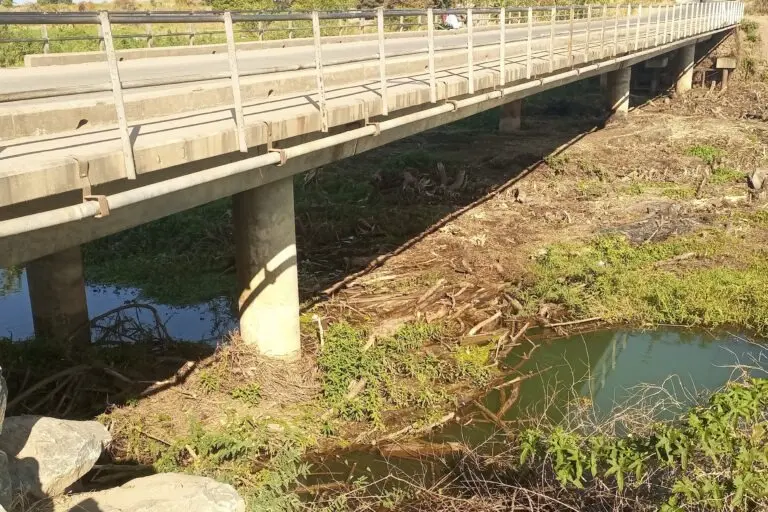
While residents noted unusual weather patterns months prior, the physical manifestation of the disaster began in earnest around February. Chia Lagoon connects to the expansive waters of Lake Malawi via a single, relatively narrow natural channel located on its western edge. According to local communities, this outlet became the focal point for an unprecedented accumulation of floating weeds, aquatic plants, and terrestrial debris.
Instead of flowing smoothly out into Lake Malawi, the immense volume of debris became wedged at the mouth of the outlet, creating a dense, natural dam. This blockage acted as a hydraulic plug, effectively reversing the system’s natural flow dynamics. Water that should have drained away from the lagoon was instead trapped and pushed backward, overflowing the banks and flooding low-lying agricultural plains.
The Lingering Submersion (Mid-2026 to Present)
Ordinarily, the lands surrounding Chia Lagoon follow a predictable seasonal cycle. Following the end of the rainy season, floodwaters recede naturally, allowing farmers to prepare fields for irrigated crops and enabling fishers to navigate freely across open waters. However, because the outlet remained choked by the vegetative plug, the water had nowhere to go.
More than half a year after the rains stopped, fields that should be dry and productive remain inundated. Farmers report that their seasonal window for planting maize and rice has been entirely disrupted. Even worse, perennial staples like cassava—which require well-drained soils—have begun to rot beneath the stagnant surface water. For fishers attempting to reach deep-water breeding grounds, the floating weed mats present a physical barrier as impenetrable as concrete, forcing them to abandon traditional fishing routes and suffer catastrophic drops in daily catch yields.
Supporting Context & Metrics: Understanding the Stakes at Chia Lagoon
The crisis at Chia Lagoon is not merely a localized inconvenience; it is a major regional emergency threatening a vital economic and ecological engine in central Malawi’s Nkhotakota district.
Geographic and Demographic Footprint
- Surface Area: Chia Lagoon spans an impressive 1,700 hectares (approximately 4,200 acres), making it the largest lagoon in Malawi.
- Direct Livelihoods: The lagoon directly supports more than 7,800 households through a diversified portfolio of activities, including rice, maize, and cassava farming, artisanal fishing, and traditional bird hunting.
- Watershed Impact: The broader river network feeding and draining the lagoon sustains more than 55,000 agriculturalists spread across the Nkhotakota district and surrounding areas.
- Biodiversity Recognition: In December 2025, just weeks before the blockage crisis intensified, Chia Lagoon was formally recognized as a Key Biodiversity Area (KBA). This designation highlights its critical importance for regional conservation, serving as a haven for a vast array of endemic and migratory bird species, diverse fish populations, amphibians, and specialized wetland flora.
The juxtaposition of this newly minted conservation status with a sudden, debilitating ecological collapse has alarmed conservationists and government planners alike. The lagoon’s rich biodiversity is now at risk of asphyxiation as stagnant waters deplete dissolved oxygen levels and degrade critical aquatic habitats.
Official Statements and Local Perspectives
The sheer scale of the weed mass has left both seasoned locals and academic researchers searching for answers. The disruption has cut deep into the social and economic fabric of Nkhotakota district.
Voices from the Water: The Human Toll
For Ali Maulidi, who leads an association representing more than 1,000 fishers in the Nkhotakota district, the current situation is entirely unprecedented.
"We have never seen anything like this," Maulidi stated in a phone interview with environmental journalists. "Due to waterlogged soils, matured cassava has rotted in some fields… We don’t understand what is happening here; but we’re worried because it’s greatly affecting us."
Maulidi’s testimony underscores the profound helplessness felt by community members who rely on the predictable rhythms of the lagoon to feed their families and earn a modest living. Without clear guidance from regional authorities on how to clear the blockage, local fishers and farmers have been left to watch their livelihoods slowly disintegrate.

The Scientific Investigation: Untangling the Root Causes
Scientists and academic researchers attempting to study the region have also found themselves stymied by the floating vegetative islands. Earlier in the year, a team of researchers—including Dr. Tiwonge Mzumara-Gawa, a prominent ecologist at the Malawi University of Science and Technology (MUST)—encountered severe access issues while conducting field research on land-use patterns within the watershed.
While Dr. Mzumara-Gawa’s research was not initially designed to investigate the weed proliferation, her field observations and broader ecological surveys offer critical clues regarding the disaster’s underlying causes. According to Mzumara-Gawa, the landscapes surrounding the lagoon are suffering from severe, systemic degradation characterized by rampant deforestation, unchecked agricultural expansion, and rapid settlement growth.
Crucially, local farmers desperate for fertile ground have increasingly encroached upon the legally protected boundaries of the wetland itself.
"It’s like this place should be wetland and nobody should be cultivating here," Mzumara-Gawa explained during a phone interview. "Pero people are cultivating there and… contributing to all of this silt that’s coming into the marsh. So that is my greater theory."
Furthermore, Mzumara-Gawa points to extreme weather volatility as the immediate catalyst for the displacement of the weeds. The region experienced two severe, distinct waves of flooding—one in December 2025 and another in January 2026. These flood events, linked to broader climatic shifts and regional heavy rainfall (such as those documented by disaster relief tracking networks), sent torrents of water rushing down from the highlands.
Mzumara-Gawa theorizes that the sheer volume and velocity of the highland runoff acted like a battering ram against the shoreline.
"Maybe this rainwater coming from the high lands came in with a lot of force," she noted. "Because when I saw the size of it [the weeds], I was like, oh this is huge. How could this break away just like that?"
The combination of severe upper-catchment deforestation, intense soil erosion, heavy siltation, and high-velocity floodwaters created a "perfect storm." Land conversion weakened the binding root systems of the marshlands, while heavy rains violently uprooted massive swathes of vegetation, funneled them downward, and wedged them tightly against the lake outlet.
Future Outlook: Mitigation, Management, and the Path Forward
As Chia Lagoon enters a prolonged period of ecological distress, the path toward recovery demands an immediate, multi-pronged strategy involving local communities, academic institutions, and national environmental management agencies.
Immediate Interventions: Clearing the Bottleneck
The most pressing priority for the Nkhotakota district is the physical removal of the weed mass and debris plug at the lagoon’s outlet. Left to decompose naturally, the massive accumulation of organic matter risks triggering severe anoxic conditions (oxygen depletion), which could cause massive fish kills and destroy the very biodiversity that earned the lagoon its KBA status in late 2025.
Emergency manual clearing operations, backed by heavy machinery where accessible, are urgently required to re-establish free-flowing drainage into Lake Malawi. Lowering the water levels back to their historical seasonal baselines will relieve the pressure on flooded agricultural plots and allow surviving crops to salvage what remains of the growing season.
Long-Term Watershed Management
Beyond emergency clearance, experts emphasize that addressing the symptoms without treating the root causes will only guarantee future catastrophes. Sustainable management of Chia Lagoon requires a comprehensive overhaul of watershed governance:
- Enforcement of Wetland Boundaries: Local authorities must strictly enforce protective buffer zones around the 1,700-hectare lagoon to prevent illegal agricultural encroachment and land conversion.
- Reforestation Initiatives: Massive tree-planting and soil conservation programs must be implemented across the higher elevations of the Nkhotakota catchment to stabilize soils, reduce runoff velocity, and curb the heavy siltation feeding the marsh.
- Community-Based Adaptation: Empowering local associations—such as Ali Maulidi’s fisher cooperative and local farming groups—with training in sustainable land-use practices will ensure that economic survival does not come at the expense of ecological health.
The crisis at Chia Lagoon serves as a stark warning for wetland ecosystems across East and Southern Africa. As climate change increases the frequency of extreme weather events, vulnerable habitats caught at the intersection of human expansion and ecological degradation will face unprecedented pressures. Only through swift, collaborative action can Malawi safeguard the ecological integrity of Chia Lagoon and secure the sustainable futures of the tens of thousands of citizens who call its shores home.