

Executive Overview
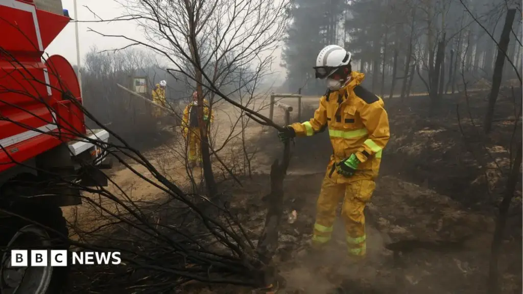
The Kingdom of Belgium is currently grappling with what local authorities and emergency management officials have confirmed as the largest wildfire in the nation’s recent history. Ravaging the fragile and ecologically vital Hautes Fagnes (High Fens) nature reserve—situated near the country’s eastern border with Germany—the inferno has expanded at an exponential and deeply alarming rate. Within a mere 24-hour window over the weekend, the blaze more than doubled in physical footprint, turning vast expanses of ancient peat bogs, dense moorlands, and evergreen forests into scorched earth.
As hundreds of exhausted firefighters enter their third consecutive day of grueling, round-the-clock combat against the advancing walls of fire, the human and environmental toll is mounting. The rapid acceleration of the blaze forced the immediate, mandatory evacuation of at least two nearby villages, while local agricultural workers mobilized in solidarity, hauling heavy water tankers toward the park perimeter. The domestic emergency response has further been bolstered by international solidarity mechanisms, with specialized water-bombing aircraft and tactical helicopters arriving urgently from Sweden and the Netherlands under the European Union Civil Protection umbrella.
This catastrophic event does not occur in a vacuum. The Belgian disaster is part of a broader, deeply distressing pan-European weekend of fire crises. Unseasonably severe weather patterns have triggered destructive forest fires across the continent, tragically claiming at least two lives on a Greek island off the coast of Athens on Sunday.
For Belgium, a country more traditionally accustomed to temperate maritime weather and manageable agricultural fires, the Hautes Fagnes disaster represents a grim watershed moment. It exposes the acute vulnerabilities of Western European ecosystems to rapid climate destabilization. Meteorological conditions characterized by protracted high temperatures, combined with the notoriously difficult subterranean fuel loads of the region’s unique boggy terrain, have severely hampered containment efforts. While interior ministers and tactical commanders report tentative victories along specific defensive perimeters, the active fire fronts continue to threaten surrounding municipalities, demanding an unprecedented mobilization of state and international resources.
Detailed Chronology: The Escalation of a Catastrophe
Friday: The Spark and Initial Spread
The crisis began quietly on Friday as a localized brush fire in the rugged terrain of the Hautes Fagnes plateau. Initially detected by park rangers and automated thermal monitoring systems, the fire was met with a standard localized response. Fire brigades from surrounding districts were dispatched to establish perimeter lines.
However, unfavorable microclimates—including dry winds and exceptionally low relative humidity—quickly turned the minor brush fire into a fast-moving threat. By Friday evening, local estimates placed the burned area at a relatively contained 80 hectares (approximately 200 acres). Emergency planners hoped that night-time temperature drops would slow the combustion rate, allowing ground crews to gain the upper hand before sunrise.
Saturday: Exponential Growth and Panic
Those hopes were systematically dashed by Saturday morning. Fueled by subterranean peat layers that can burn invisibly and stubbornly beneath the surface, the fire underwent a terrifying phase of exponential growth. By dawn, the footprint of the disaster had exploded to 850 hectares.
The rapid proliferation of smoke plumes, visible for dozens of kilometers across eastern Belgium and spilling over into western Germany, triggered immediate panic and swift administrative action. Local mayors, acting on recommendations from civil protection commanders, ordered the mandatory evacuation of two vulnerable villages bordering the nature reserve. Residents were instructed to gather designated emergency supplies and move to temporary reception centers established in nearby community halls.
Ground crews found themselves systematically outmatched. The terrain—characterized by treacherous, water-logged bogs that can easily swallow heavy firefighting vehicles, interspersed with dry, highly combustible pine needle litter—rendered standard tactical vehicle deployments nearly impossible. Firefighters were forced to rely on manual trenching, backpack sprayers, and defensive line-holding strategies, even as wind gusts pushed embers hundreds of meters ahead of the main front, sparking dangerous spot fires.
Sunday: The 3,000-Hectare Milestone and International Reinforcements
By early Sunday morning, the situation had deteriorated past the worst-case scenarios modeled by emergency services. According to reports released by the Agence France-Presse (AFP) citing municipal and regional officials, the total area consumed by the inferno had skyrocketed to an unprecedented 3,000 hectares.
The scale of the disaster necessitated a massive escalation in tactical capabilities. Early Sunday saw the arrival of heavy aerial assets dispatched from foreign partners. Swedish and Dutch water-bombing aircraft began executing precision drops over the inaccessible interior of the plateau, scooping water from nearby reservoirs and dumping thousands of liters of retardant-laced water directly onto the heart of the active fronts.
On the ground, an unconventional auxiliary force joined the regular emergency personnel: local Belgian farmers. Demonstrating extraordinary civic commitment, these agricultural workers hitched heavy industrial water tankers to their tractors, navigating rough logging roads to supply remote fire engines that were otherwise cut off from municipal water hydrants.
Despite these heroic efforts, by Sunday afternoon, the primary active front remained stubbornly resilient, stretching approximately one kilometer in length. While tactical interventions successfully halted the fire’s progression toward certain population centers, the overall containment percentage remained precarious as shifting afternoon winds threatened to push the flames into fresh, unburned sectors of the reserve.
Supporting Context & Metrics: Anatomy of a Disaster
To understand why the Hautes Fagnes fire has proven so exceptionally difficult to contain, one must examine the unique geography, climatic anomalies, and statistical metrics defining this environmental crisis.
Geographical and Ecological Profile of Hautes Fagnes
The Hautes Fagnes (known in German as Hohes Venn) is an upland plateau region situated primarily in the Belgian province of Liège, extending into the Eifel region of Germany. Spanning tens of thousands of hectares, it is Belgium’s largest and most ecologically sensitive nature reserve.
The park is defined by a unique combination of high-altitude blanket bogs, acidic moorlands, sphagnum moss environments, and dense coniferous and deciduous forests. These fragile ecosystems act as crucial carbon sinks, storing centuries of accumulated organic matter. Paradoxically, while the region is traditionally known as one of the wettest areas in Belgium—frequently shrouded in mist and subjected to high annual rainfall totals—its underlying geology creates a dangerous paradox during dry spells.
The Subterranean Threat: Peat Fires
The core challenge facing firefighters in the Hautes Fagnes is the presence of deep peat deposits. Peat is composed of partially decayed organic plant material that has accumulated over millennia in water-saturated environments. When prolonged drought or unseasonable heat dries out the upper layers of a bog, this peat becomes exceptionally flammable.
Unlike standard forest fires that consume surface canopy and underbrush, peat fires burn beneath the surface at smoldering temperatures without producing high, visible flames. They can travel silently underground through root systems and organic layers for days, defying surface dousing efforts. When firefighters believe an area is completely extinguished, hidden subterranean embers can reignite the surface brush days later under the influence of oxygen and wind. This phenomenon has forced Belgian emergency crews to engage in exhaustive, labor-intensive "mop-up" operations, digging trenches deep into the soil to isolate burning peat pockets from uncompromised sectors.
Comparative Metrics of the Crisis
- Total Area Burned: Escalated from 80 hectares on Friday to 850 hectares by Saturday morning, ultimately reaching a staggering 3,000 hectares by Sunday.
- Timeline of Response: Entering its third consecutive day of active containment operations as of Sunday evening.
- Personnel Deployed: Hundreds of professional municipal firefighters, regional forestry workers, civil protection units, and international aircrews.
- Evacuations: Two rural villages fully evacuated under mandatory civil defense orders, with residents housed in temporary municipal shelters.
- International Aid: Strategic deployment of specialized firefighting aircraft and support helicopters from Sweden and the Netherlands.
- Broader European Impact: Concurrent major wildfire events across Southern and Central Europe, highlighted by fatal forest fires on a Greek island near Athens.
Official Statements and Crisis Management
As the crisis unfolded over the weekend, high-ranking government officials, emergency management directors, and municipal leaders held regular press briefings to update the public and outline tactical adjustments.
Belgian Interior Minister Bernard Quintin provided a measured assessment of the tactical landscape during a Sunday afternoon briefing. Addressing the press, Minister Quintin confirmed that progress had been made along specific geographic axes.
"We have successfully brought two major fronts of the fire—specifically those heading dangerously in the direction of Jalhay and Monschau—under control," Minister Quintin stated. "The establishment of robust defensive firebreaks by our ground teams, combined with timely aerial interventions, has neutralized the immediate threat to those specific communities."
However, the Interior Minister was careful to temper any premature optimism, emphasizing that the overall emergency was far from resolved.
"Despite these localized successes, the situation remains highly dynamic and profoundly challenging," Quintin warned reporters. "The active front continues to advance, currently measuring approximately one kilometer in length. Our primary objective remains the absolute protection of human life and infrastructure. While no residential homes have been destroyed or directly impacted thus far, we cannot lower our guard. The atmospheric conditions and the specific nature of the terrain mean that a sudden shift in wind direction could jeopardize our gains instantly."
Local municipal authorities echoed these cautions, praising the resilience of the local population and the selfless contributions of the farming community. Mayors of the evacuated districts stressed that return orders would not be issued until comprehensive air-quality monitoring and structural safety assessments could be completed by civil protection engineers.
Commanders from the European Union Civil Protection Mechanism lauded the swift operational integration of the Swedish and Dutch aerial units. Operating in unfamiliar airspace over complex, rolling terrain, foreign pilots executed dozens of targeted water drops, demonstrating the vital importance of cross-border European solidarity in mitigating climate-induced natural disasters.
Future Outlook: Mitigation, Recovery, and Climate Resilience
As emergency services transition from aggressive containment to eventual mop-up and recovery operations, the Hautes Fagnes wildfire will undoubtedly leave a lasting legacy on Belgian public policy, environmental management, and national security planning.
Short-Term Recovery and Environmental Assessment
Once the flames are fully extinguished, federal and regional environmental agencies face the monumental task of assessing the ecological damage. The loss of 3,000 hectares of sensitive bogland and forest canopy represents an irreparable blow to local biodiversity. Endangered bird species, specialized amphibians, and rare flora unique to the moorland ecosystem have suffered catastrophic habitat loss. Furthermore, the incineration of centuries-old peat layers releases massive quantities of stored carbon dioxide back into the atmosphere, exacerbating the very climatic trends that helped enable the disaster.
Hydrological experts have also warned of secondary environmental hazards in the wake of the fire. The destruction of vegetation cover, combined with the hydrophobic properties of scorched soil, creates a severe risk of flash flooding and severe mudslides should heavy autumn rains arrive before natural ground stabilization can occur. Constructing erosion barriers and emergency drainage controls will require immediate financial outlays from regional authorities.
Long-Term Policy Implications
The unprecedented nature of the Hautes Fagnes fire has shattered the complacency that traditionally characterized Northern and Western European disaster preparedness regarding wildfires. Historically, catastrophic crown fires and out-of-control blazes were viewed as problems exclusive to Southern Europe, California, or Australia.
This disaster serves as an undeniable wake-up call for policymakers in Brussels and regional capitals. Experts are already calling for a comprehensive overhaul of national emergency response frameworks, including:
- Investment in Domestic Aerial Fleets: Critics have pointed out Belgium’s historical reliance on neighboring countries for heavy water-bombing aircraft. Calls are mounting for the establishment of a dedicated national or Benelux-shared aerial firefighting fleet to ensure immediate response times without waiting for international deployment authorizations.
- Advanced Early-Warning Infrastructure: Integrating artificial intelligence-driven thermal imaging cameras and satellite monitoring networks across all major Belgian nature reserves to detect subterranean peat fires and surface ignition points within minutes of occurrence.
- Ecosystem Adaptation Strategies: Modifying forestry management practices to reduce monoculture pine plantations, which are highly combustible, and actively restoring natural, water-retaining deciduous woodlands and hydrated peat bogs that act as natural firebreaks.
Ultimately, the 3,000-hectare scar across the Hautes Fagnes will stand for generations as a visible reminder of a changing climate. As Europe faces increasingly extreme weather anomalies, the lessons learned from this historic Belgian tragedy will dictate whether civil defense systems can successfully adapt to an increasingly volatile environmental future.



