The Rohingya refugee camps in southeastern Bangladesh are facing an escalating humanitarian and environmental crisis. According to a government report released on September 16, more than 150,000 Rohingya refugees fleeing ongoing persecution and conflict in Myanmar have entered the country’s 33 overcrowded camps in the Teknaf and Ukhiya regions of Cox’s Bazar over the past few months.
This latest influx places an unprecedented strain on settlements that already officially host 1,170,978 dwellers within a cramped 24-square-kilometer (9.2-square-mile) area. With a staggering density exceeding 124,300 people per square mile, the camps have become critical pressure cookers. Built on fragile sandy hill slopes following the large-scale clearing of reserved forests, the settlements are increasingly vulnerable to catastrophic natural disasters.
Monsoon downpours regularly trigger deadly landslides, and recent seasons have proved exceptionally destructive. Between July 4 and 19 alone, more than 200 landslides struck the camps, claiming at least 15 lives—including five adolescent girls—and displacing upwards of 13,000 residents. Compounding these physical hazards are severe financial shortfalls. Humanitarian programs dedicated to disaster risk reduction, site management, and emergency slope stabilization are severely underfunded, leaving humanitarian workers and government officials racing against time to prevent further loss of life.
Detailed Chronology of the Crisis
The origins of the current environmental and humanitarian emergency trace back to the massive forced displacement of Rohingya Muslims from Myanmar’s Rakhine State, particularly during the brutal military crackdown of 2017.
2017 (The Initial Mass Influx): Hundreds of thousands of refugees flooded across the border into Cox’s Bazar. To shelter the sudden arrivals, vast swaths of forested hills were rapidly cleared. The initial influx resulted in the immediate destruction of 1,502 hectares (3,713 acres) of forest lands. Makeshift shelters made of bamboo and plastic sheeting were thrown up overnight on steep, unstable gradients.
2019 (Environmental Impact Assessment): Two years after the initial wave, the Bangladesh Forest Department released a comprehensive report revealing that Rohingya settlements had severely degraded regional biodiversity. The report documented the depletion of more than 3,230 hectares (8,000 acres) of reserved forest in Cox’s Bazar, radically altering the local topography and removing natural root systems that previously anchored the soil.
2020–2021 (Landscape and Hazard Mapping): Academic studies tracking landscape changes in Ukhiya—home to Kutupalong, the world’s largest refugee camp network—noted that ongoing human activities, such as slope cutting, road building, and the construction of staircases on elevated terrain, significantly escalated the risk of landslides and flooding. A geological mapping project revealed that the number of slope units exhibiting moderate-to-high landslide susceptibility spiked from 109 before the influx to 291 by 2021.
2018–2025 (Historical Disaster Toll): Between 2018 and 2025, over 3,100 landslide incidents were officially recorded across the Rohingya settlements, directly affecting more than 73,000 individuals.
July 2026 (Monsoon Crisis Peak): Between July 4 and 19, a relentless sequence of monsoon storms triggered over 200 landslides across the camps. The disasters killed 15 people, displaced more than 13,000, and heavily damaged fragile shelters, exposing the widening gap between disaster mitigation needs and available resources.
September 2026 (New Arrivals and Official Reports): On September 16, the Bangladeshi government published a sobering update confirming that over 150,000 additional refugees had arrived from Myanmar over the preceding months. Camp managers reported that incoming families were being accommodated by cutting deeper into already compromised hill slopes to expand existing shelters, further elevating multi-level disaster risks.
Supporting Context & Metrics
To fully understand the gravity of the crisis in Cox’s Bazar, one must examine the intersection of geomorphology, extreme weather, and extreme human density.
Geomorphological Realities
Cox’s Bazar is predominantly a floodplain with a mean slope of approximately 4° and an average elevation of 17 meters (56 feet) above global mean sea level. Its complex geomorphology features flat floodplains, mudflats, sand dunes, tidal creeks, and sandy hillocks.
Geological studies assessing rainfall-induced landslide risks in the Kutupalong camp network highlight that the region’s landmass is underlain mainly by Tipam sandstone, Girujan clay, and Dupi Tila formations of fluvial sandstone, clay, and beach deposits. Most slope failures occur within residual soils and weathered silty sandstone. When these formations are subjected to heavy monsoon downpours and destabilized by unengineered slope cuts, they lose shear strength and fail catastrophically.
Initial Deforestation: 1,502 hectares (3,713 acres) destroyed in 2017.
Expanded Forest Loss: >3,230 hectares (8,000 acres) of reserved forest severely degraded by 2019.
A 2025 scientific study mapping 1,726 individual slope units within the Kutupalong camps categorized remediation requirements into three urgency tiers:
Immediate Stabilization Priority: 287 slopes.
Short-Term Priority: 428 slopes.
Long-Term Priority: 505 slopes.
Despite these clear diagnostic blueprints, execution remains severely bottlenecked by financial shortfalls and a lack of available physical space.
Official Statements and Stakeholder Perspectives
The management of the world’s largest refugee settlement presents an intractable policy dilemma for the government of Bangladesh, caught between humanitarian obligations and severe domestic land and environmental constraints.
Mohammed Mizanur Rahman, Bangladesh’s Refugee Relief and Repatriation Commissioner (RRRC), emphasized the impossibility of further territorial expansion during an interview with Mongabay on September 8:
"The refugee community demands camp expansion with continued influx from Myanmar. But any expansion means destruction of new forests and hills, and Bangladesh cannot afford it anymore."
Commissioner Mizanur also pointed directly to the root cause of infrastructural vulnerabilities:
"Fund shortages severely impact disaster risk management in the camps."
Scientific experts working on the ground echo these warnings while emphasizing the physical mechanics of the risk. Shamima Ferdousi Sifa, assistant professor at the University of Dhaka’s Department of Disaster Science and Climate Resilience and co-author of the 2025 landslide study, noted that changing rainfall patterns are exacerbating pre-existing structural vulnerabilities:
"As long as housing settlements continue to expand onto unstable slopes, Rohingya refugees will remain at risk of landslides."
Local camp administrators witness these pressures daily. Rintu Bikash Chakma, in charge of Camp 8 West in Kutupalong, explained how the new influx forces families to endanger themselves:
"Remaining hill slopes are further cut to expand existing houses to shelter camp residents’ relatives when they arrive from Myanmar. This leaves the houses above and below the cut slopes vulnerable to landslides."
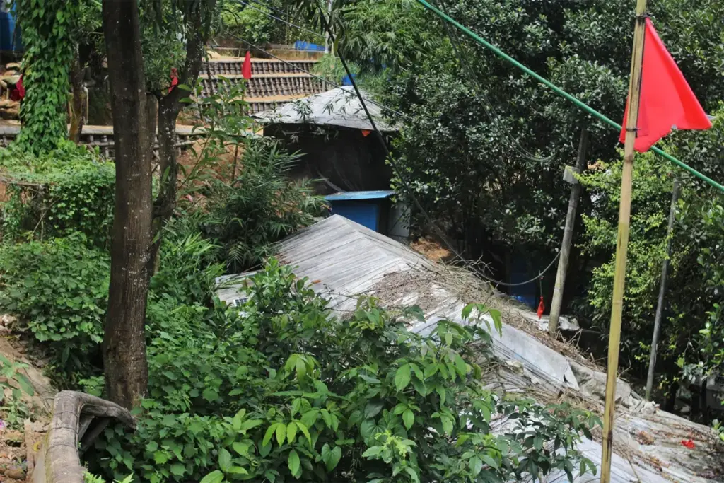
Despite camp officials hoisting red flags at high-risk slopes every monsoon season to warn residents, human realities often override official warnings. At Camp 4 in Kutupalong, 55-year-old Morium Begum—who lives with five family members in a shelter on a red-flagged slope where they have stayed since 2017—expressed a grim resignation:
"The authorities may make the slope landslide-resistant or send us back to Myanmar. I would rather risk dying in a landslide than move from the place where we have built our lives."
Future Outlook and Funding Deficits
The long-term viability of the Cox’s Bazar refugee settlements hangs in the balance. As ongoing conflict in Myanmar drives continuous new arrivals, the demographic pressure on a capped geographic area guarantees that human density will only intensify. Without expansive relocation options or substantial engineering interventions, the risk profile of the camps will deteriorate further with every coming monsoon season.
Disaster risk mitigation is structurally constrained by severe funding gaps within the international humanitarian framework. Official documents from the Rohingya Refugee Response collective outline stark deficits:
Access, Safety, and Disaster Risk Management Program: Funded at only 40% as of July 2026, leaving a $23.2 million to $23.8 million shortfall against its $38.8-million requirement.
Shelter and Camp Coordination Camp Management (SCCCM): Similarly underfunded at 42%, requiring an additional $73.9 million for emergency slope stabilization, drainage construction, watershed management, and climate-resilient retrofitting.
Without immediate, fully funded international intervention to stabilize high-risk slopes, install robust drainage networks, and support alternative housing models, thousands of Rohingya refugees remain exposed to imminent environmental disasters. For Bangladesh, which has borne the brunt of this humanitarian crisis for nearly a decade, the situation underscores an unsustainable status quo—balancing the moral imperative of refuge against severe ecological degradation, dwindling international aid, and the unyielding fury of the monsoon season.