

Executive Overview
Hurricane Polo has delivered a devastating blow to the western coastline of Mexico, making an aggressive landfall along the northern Pacific shore of the Baja California Sur state. Packing maximum sustained winds of 110 mph (175 km/h)—just shy of major hurricane status—the tempest brought immediate life-threatening hazards, including torrential downpours, severe storm surges, and extensive coastal flooding. The storm tore ashore just south of the picturesque surfing and fishing enclave of Las Barrancas, unleashing widespread power outages, structural damage, and prompting mandatory evacuations across vulnerable low-lying communities.
As the storm’s core churns northeast across the rugged terrain of the Baja California peninsula, emergency services, civil protection agencies, and local authorities are grappling with the immediate fallout. Meteorologists warn that the threat is far from over. Polo is expected to maintain its hurricane intensity as it tracks toward a secondary landfall on the Mexican mainland over the southern portion of the state of Sonora.
Beyond its immediate impacts on Mexican soil, Hurricane Polo is acting as a meteorological catalyst on a continental scale. Fueled by unusually warm Pacific Ocean temperatures supercharged by the El Niño climate phenomenon, the storm is interacting with the remnants of another tropical system, Hurricane Odalys. This convergence is pumping a vast plume of tropical moisture northward into the United States Southwest. States spanning from Arizona and California to Colorado, New Mexico, and Utah are bracing for excessive rainfall and significant flash-flooding risks over the coming days. This report provides a detailed breakdown of the meteorological chronology, on-the-ground impacts, humanitarian responses, institutional warnings, and the broader climatic context defining this unfolding natural disaster.
Detailed Chronology of the Event
Approach and Escalation
For days prior to its landfall, Hurricane Polo tracked steadily across the warm waters of the eastern Pacific, its intensity steadily mounting under favorable atmospheric conditions and exceptionally high sea-surface temperatures. As the system organized, forecasters at the United States-based National Hurricane Center (NHC) and Mexico’s Servicio Meteorológico Nacional (SMN) issued continuous advisories, charting the storm’s inexorable march toward the Baja California peninsula.
By Monday, the outer rainbands of the hurricane began lashing the southern tip of the peninsula—a region renowned globally for its luxury tourism, sportfishing, and whale-watching expeditions. Authorities in iconic locales such as Cabo San Lucas proactively restricted beach access, shuttered ports, and urged tourists and locals alike to monitor the storm’s trajectory. Despite these early warnings, the sheer velocity and structural consolidation of Polo caught some remote coastal communities by surprise as conditions deteriorated rapidly overnight.
Landfall and Immediate Impacts
Polo officially made landfall just south of Las Barrancas, bringing ferocious, life-threatening winds and torrential rain that instantly overwhelmed local drainage infrastructure. Hours before the eye crossed the coastline, residents reported sudden, widespread power blackouts that plunged entire municipalities into darkness.
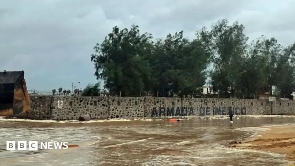
In the fishing town of Puerto San Carlos, storm surges battered sea barriers, sending aggressive ocean water spilling over coastal defenses and inundating residential and commercial properties. US media outlets and local reporting agencies confirmed significant flooding throughout low-lying neighborhoods. Many residents had heeded early evacuation orders, retreating to designated municipal emergency shelters, while those who chose to ride out the storm engaged in last-minute desperate efforts to board up windows and secure rooftops against the oncoming fury.
As Tuesday progressed, the core of the hurricane began its anticipated northeastward traverse over the rugged interior of Baja California Sur. While the friction of the terrain is expected to gradually degrade the storm’s structural integrity, meteorologists emphasize that Polo remains a potent and dangerous meteorological entity. The storm is currently projected to track off the peninsula, cross the Gulf of California (Sea of Cortez), and make a secondary landfall over the southern reaches of mainland Mexico’s Sonora state later on Tuesday.
Supporting Context & Metrics: Data, Climate, and Regional Fallout
Meteorological Metrics and Forecast Models
The quantitative data associated with Hurricane Polo underscore its severity:
- Maximum Sustained Winds: 110 mph (175 km/h) at the time of landfall, placing it just 1 mph below the threshold for a Category 3 major hurricane on the Saffir-Simpson scale.
- Rainfall Accumulations: Forecast models predict between 6 and 12 inches (150 to 300 mm) of rain across isolated regions of Baja California Sur, with localized amounts potentially exceeding these figures in mountainous terrain.
- Secondary Landfall: Maintained hurricane-force winds projected upon striking mainland Sonora.
- US Continental Moisture Surge: Remnants of Polo and Hurricane Odalys merging into a broader weather pattern, threatening parts of Arizona, New Mexico, Colorado, and Utah with 6 to 7 inches of cumulative rainfall by Thursday.
The El Niño Factor and Ocean Temperatures
The unusual ferocity and active nature of the current Pacific hurricane season are not occurring in a vacuum. Climatologists attribute the intensification of storms like Polo to exceptionally warm ocean waters driven by the El Niño climate phenomenon. El Niño typically suppresses hurricane activity in the Atlantic basin while dramatically enhancing it in the Eastern Pacific by reducing vertical wind shear and providing deep, warm oceanic heat reservoirs that act as primary fuel for tropical cyclogenesis. As global sea surface temperatures continue to rise, meteorological experts warn that coastal communities along the Pacific basin must prepare for an increased frequency of high-intensity, rapid-intensification storm events.
Continental Spillover: The US Southwest Threat
As Hurricane Polo’s remnants transition northeastward, their atmospheric footprint will extend far beyond Mexican borders. The merger of Polo and Hurricane Odalys is creating a massive atmospheric river aimed squarely at the American Southwest.
States that are typically arid or semi-arid are facing unprecedented water loads. Flash-flood watches and warnings have been disseminated across Arizona, New Mexico, Colorado, and Utah. Rain has already begun falling in parts of Southern California and Arizona, but the true deluge is expected as the consolidated moisture plume pushes eastward across the southern plains. Urban centers and rural communities alike are being urged to clear storm drains, secure outdoor property, and prepare for potential riverine flooding and dangerous mudslides in wildfire burn scars.
Official Statements and Local Testimonies
On-the-Ground Perspectives
The human cost and psychological toll of the hurricane are best captured through the voices of those living directly in the path of destruction.
María Palomino, a 57-year-old local shopkeeper, made the pragmatic decision to abandon her home ahead of the storm. She spent the harrowing night inside a high school gymnasium that civil protection authorities converted into a temporary emergency evacuation center. Speaking to international news agency AFP, Palomino reflected on her choice: "If something happens, it’s better to come to the shelter. You cannot fight against nature when it brings such anger."
In Las Barrancas, a local whale-watching and fishing guide spent his final hours of daylight frantically hammering wooden planks across the facade of his home. Interviewed as howling winds began to pick up, he offered a grim assessment of the impending disaster: "The storm is coming with full force. We have seen bad weather before, but this one feels different; it feels personal."
Institutional Warnings and Civil Protection Directives
Government agencies and international meteorological bodies have maintained a synchronized posture of urgency throughout the event.
The United States National Hurricane Center issued detailed bulletins highlighting the compound dangers of the storm:
"Near the coast, the storm surge will be accompanied by large and destructive waves, producing significant coastal flooding in areas of onshore winds. Residents must remain indoors and heed all local civil protection directives until the all-clear is officially given."
Mexican federal civil protection authorities, working in tandem with state governments in Baja California Sur and Sonora, mobilized National Guard units, medical personnel, and emergency relief supplies. Officials reiterated that the combination of torrential rainfall and steep regional topography creates an extreme risk of catastrophic flash floods and deadly mudslides. Search and rescue teams remain on high alert, poised to deploy heavy equipment and watercraft the moment weather conditions permit access to the hardest-hit, isolated rural sectors.
Future Outlook and Recovery Phase
Immediate Challenges in Baja California Sur and Sonora
As Hurricane Polo continues its northeast trajectory toward mainland Mexico, the immediate focus in Baja California Sur will transition from emergency survival to damage assessment, search and rescue, and infrastructure stabilization. Key priorities for regional governments will include:
- Restoring Critical Infrastructure: Repairing downed electrical grids, clearing blocked roadways of mud and debris, and re-establishing compromised telecommunication lines to reconnect isolated communities.
- Potable Water and Sanitation: Ensuring that municipal water supplies are safe from contamination and distributing emergency rations to displaced populations residing in shelters.
- Managing Secondary Landfall: Pre-positioning emergency response assets in Sonora ahead of Polo’s second landfall to mitigate structural damage and prevent loss of life in mainland communities.
Long-Term Implications for Coastal Resilience
Disasters like Hurricane Polo serve as stark reminders of the vulnerability of coastal infrastructure in an era of shifting climatic baselines. Urban planners, environmental scientists, and local policymakers face mounting pressure to re-evaluate zoning laws, bolster coastal defense structures, and invest in resilient, climate-adaptive architecture.
For the tourism and fishing economies of Baja California Sur, the road to recovery will require substantial financial investment and concerted governmental support. However, the immediate imperative remains clear: ensuring the safety of all citizens, mitigating the compounding risks of flash flooding and storm surges, and weathering the final stages of a tempest that has left an indelible mark on Mexico’s western coast.



