

Executive Overview
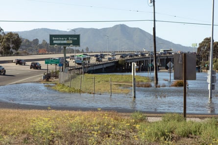
On a deceptively clear, cloudless autumn afternoon just north of San Francisco, sunlight sparkled over a surreal scene: a bustling highway intersection quietly swallowed by standing water, causing rush-hour traffic to grind to a painful, multi-mile crawl. There were no crashing ocean waves, nor was there an active atmospheric river or a violent storm surge to blame for the inundation. Instead, this peaceful yet alarming flooding was driven by a combination of high seasonal tides and an excess of thermal energy swelling the Pacific Ocean.
For Marin County and communities up and down the 770-mile California coastline, these submerged streets serve as a stark, early-warning signal. The state is bracing for what federal forecasters and emergency managers warn could be a historically tumultuous winter season. Driven by a strengthening, potentially historic El Niño weather pattern—supercharged by decades of underlying climate change—California finds itself squarely in the crosshairs of compounding natural hazards.
State and local agencies are no longer just preparing for isolated weather events. Instead, they are organizing a massive, multi-tiered defensive mobilization against a convergence of concurrent threats: flash floods, catastrophic debris flows across recent wildfire burn scars, explosive surf, severe coastal erosion, and an extra foot of sea-level rise driven by a surging warm-water mass known as a "Kelvin wave." With Governor Gavin Newsom having declared a state of emergency, public works departments, emergency management offices, and local communities are racing against the calendar. Their goal is clear: fortify infrastructure, clear critical drainage arteries, and instill a culture of neighborhood-level resilience before the first major winter storms arrive.
Detailed Chronology of the Threat and Mobilization
The timeline leading up to this winter’s heightened state of alert has been marked by rapid meteorological shifts, intensifying ocean anomalies, and decisive administrative actions from state leaders.
Late Summer to Early Fall: The Warning Signs
- Early September: Unusually warm equatorial sea surface temperatures officially trigger federal El Niño advisories. Concurrently, a massive mass of subsurface warm water—a Kelvin wave—begins its slow, destructive crawl up the California coastline, raising baseline sea levels by up to a foot.
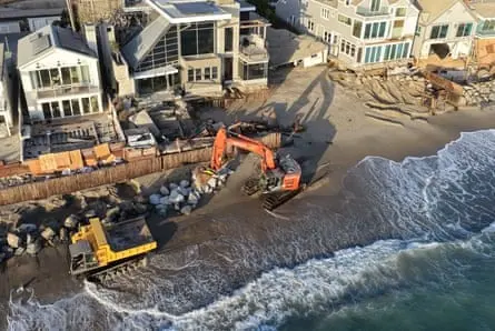
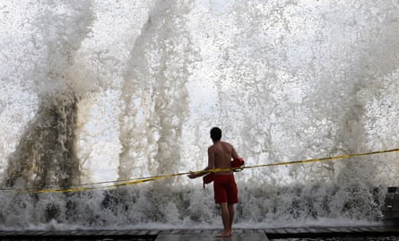
- Mid-September: Heavy surf and high tidal surges batter parts of Hawaii and the Southern California coastline. Beaches are devoured by aggressive waves, and structural damage is reported along vulnerable waterfront properties in areas like Long Beach and Dana Point.
- September 21: Recognizing the escalating risks of concurrent natural disasters, California Governor Gavin Newsom signs an official state of emergency proclamation. This executive action cuts through administrative red tape, fast-tracking funding, resource pre-positioning, and emergency contracting for at-risk counties.
- Late September to Early October: A brutal, late-season heatwave shatters temperature records across Southern California. This prolongs the high-risk wildfire season deep into autumn, forcing emergency management agencies to simultaneously battle active fires while preparing flood-control infrastructure for the upcoming wet season.
- October: Coastal municipalities initiate pre-emptive flood mitigations. Public works departments in Orange County, San Diego, Los Angeles, and San Francisco begin deploying record amounts of sand, building massive beach berms, and clearing debris basins months ahead of their typical schedules.
Supporting Context & Metrics: The Science of a Super El Niño
To understand the unprecedented scale of California’s current preparations, one must examine the complex meteorological and oceanographic factors converging on the West Coast.
The Mechanics of El Niño and the Kelvin Wave
El Niño is a naturally occurring climate phenomenon defined by warmer-than-average sea surface temperatures in the central and eastern tropical Pacific Ocean. When paired with positive feedback loops from global climate change, these events can drastically alter jet stream patterns, funneling moisture-laden atmospheric rivers directly toward the western United States.

However, the physical manifestation of El Niño extends far beyond atmospheric changes. As state climatologist Michael Anderson notes, the current oceanic conditions are supercharging sea levels along the California coast. This adds a critical foot of temporary sea-level rise directly on top of the 8 to 12 inches of permanent sea-level rise the state has already absorbed over the past century due to global warming.
This oceanic swelling is largely driven by Kelvin waves—vast underwater pulses of warm water that traverse the Pacific basin. When these thermal waves hit the shallow continental shelf of the West Coast, they elevate tides to dangerous, record-breaking heights. According to the National Weather Service, California’s upcoming "king tides"—periods when the sun and moon’s gravitational pulls align to create the highest surf of the year—are scheduled to peak during major holiday windows: the weeks of Thanksgiving and Christmas, as well as the Martin Luther King Jr. long weekend. This timing threatens coastal infrastructure and tourism hubs during peak travel periods.
The Burn Scar Vulnerability Index
Perhaps the most perilous variable in this winter’s forecast is the fragile state of California’s watersheds. Burn scars left behind by recent catastrophic wildfires—including the extensive slopes of Big Sur and neighborhoods ravaged by the massive Southern California firestorms—remain highly unstable.
Hydrological experts emphasize that it typically takes a minimum of five years for a burned watershed and its denuded hillsides to naturally regenerate enough vegetation and root structure to withstand high-intensity rainfall. When heavy El Niño storms dump torrential rain onto these vulnerable burn scars, the result is rarely simple flooding. Instead, it triggers fast-moving, destructive debris flows and mudslides that can sweep away homes, block major transit corridors, and endanger human lives with little to no warning.
Official Statements and Strategic Perspectives
Emergency managers, municipal leaders, and meteorological experts across the state have been vocal about the gravity of the situation, stressing that preparation must extend far beyond government response.
-
Nick Brubaker, Chief Resilience Officer, Marin County Office of Emergency Management:
"What we’re really looking at is the compounding element. The biggest concern isn’t just rising tides. It’s the way everything could collide… We are trying to make sure that people are aware that this may be one of the most significant El Niño years that we’ve seen."
-
Dr. Ariel Cohen, Meteorologist, National Weather Service:
"What the science supports is elevated risk. A strong El Niño shifts the probabilities—it does not determine exact outcomes."
-
Mark Pestrella, Director, Los Angeles County Public Works Department:
"We are assuming it is going to rain and with El Niño we assume it is going to rain with high intensity… Our flood control systems are designed to withstand a 100-year event, but El Niño could bump those chances higher. Watersheds and hillsides still recovering from past fires simply cannot handle that kind of shock easily."
-
Kevin McGowan, Director, Los Angeles Office of Emergency Management:
"We are in the middle of fire season and about to head into a significant heatwave. People should continue to prepare not just for one hazard—but all hazards… We are never going to have enough resources at the onset of a disaster to support every single person. Our communities are the fabric that gets us through these disasters—neighbors helping neighbors saves lives."
-
Mary Ellen Carroll, Executive Director, San Francisco Department of Emergency Management:
"It feels like I’m planning for an earthquake, but I’ve gotten two months’ notice… For vulnerable populations—older individuals and those who are medically dependent—long power outages during major storms can get very dangerous quickly."
Future Outlook: Building Community Resilience
As California stands on the precipice of what meteorologists predict will be an extraordinary winter, emergency planners universally agree that physical fortifications alone—sandbags, concrete seawalls, dredged debris basins, and repaired piers—will not be enough to prevent catastrophe.
Municipalities from Santa Cruz down to San Diego are shifting their operational paradigms toward decentralized, grassroots resilience. By launching neighborhood-focused workshops, local governments are empowering citizens to draft household emergency plans, establish communication trees, and understand localized risks via real-time interactive mapping tools.
The overarching consensus among emergency authorities is sobering yet pragmatic: total invulnerability against the forces of a changing climate and a historic El Niño is an unattainable illusion. However, the difference between a minor seasonal setback and an unrecoverable civic tragedy lies within the strength of community bonds. As local leaders frequently remind residents, when the first major storms break over the Pacific and collide with California’s fragile coastline, the ultimate line of defense will not be found in state-level emergency declarations or municipal equipment yards—it will be found in neighbors helping neighbors.



