By Investigative Environmental Desk
Published in partnership with Mongabay Conservation News
Executive Overview
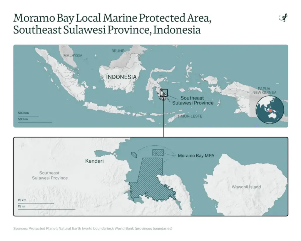
Nestled within the breathtaking expanse of Southeast Sulawesi, Indonesia, the Moramo Bay Local Marine Protected Area (LMPA) stands as a frontline battleground between aggressive industrial resource extraction and vital global marine conservation. Spanning nearly 22,000 hectares of vibrant coastal waters, mangroves, and seagrass meadows, this ecological haven is part of the world-renowned Coral Triangle—often celebrated as the "Amazon of the Seas" for its peerless marine biodiversity.
However, a crisis is unfolding beneath the turquoise surface. Recent government surveys and independent scientific assessments reveal that the region’s population of the iconic humphead wrasse (Cheilinus undulatus)—a critically depleted, giant reef fish whose historic presence helped justify the bay’s initial conservation protections—is hurtling toward local extinction. Across standardized sampling stations, researchers recorded a meager total of just 22 individuals, averaging a dismal 1.17 fish per hectare. At multiple sites where the species flourished as recently as 2018, surveyors found absolute silence: zero fish.
Compounding this ecological distress is a profound regulatory paradox. Multiple commercial mining permits for limestone, construction aggregate, and nickel overlap directly with the designated conservation boundaries or press tightly against its fragile shorelines. While government officials maintain that no direct causal link has yet been empirically established between industrial mining and the dramatic disappearance of the humphead wrasse, marine biologists warn that unchecked sedimentation, chronic coastal turbidity, and habitat degradation threaten to unravel the entire ecosystem. As environmental advocates demand immediate accountability and comprehensive permit reviews, the future of Moramo Bay hangs in a precarious balance.

Detailed Chronology: From Pristine Sanctuary to Overlapping Concessions
The trajectory of Moramo Bay reflects a long-standing tension in Indonesian environmental governance: the legal friction between top-down conservation mandates and pre-existing or expanding extractive industries.
- 2011: Recognizing the extraordinary ecological value of Southeast Sulawesi’s coastal waters—specifically noting the presence of flagship species like the humphead wrasse—local authorities and conservationists first proposed Moramo Bay as a protected marine sanctuary.
- 2013: The South Konawe Regency government enacted Regional Regulation No. 19/2013, establishing the district’s spatial plan for 2013–2033. Under this framework, various coastal plots and mainland zones adjacent to the bay were classified as permissible for mining and quarrying activities.
- 2014–2016: The proposed conservation zone underwent successive expansions, growing from 10,371 hectares in 2014 to 21,786 hectares in 2016, as ecological surveys underscored the vital connectivity of local coral reefs and marine habitats.
- 2015: Commercial mining entities, including PT Citra Khusuma Sultra (CKS) and PT Ramadhan Moramo Raya (RMR), secured major operational permits for Class C quarry materials (limestone and construction stone), covering 122 hectares and 11 hectares respectively.
- 2021: In a major milestone for marine protection, the Indonesian Ministry of Marine Affairs and Fisheries formally designated Moramo Bay and its surrounding islands as a unified 21,902-hectare conservation area, spanning South Konawe, Konawe regencies, and the coastal city of Kendari.
- 2020–2023: South Konawe issued Regional Regulation No. 5/2020, replacing the 2013 spatial plan for the 2020–2040 period. The updated framework explicitly revoked certain mining allowances in designated tourist destinations and marine sectors. Nevertheless, controversial permit extensions were later granted to existing operators through 2030, while new entities like PT Hoffmen Energi Perkasa (HEP) secured exploration rights in 2023, transitioning to a production permit spanning 2026 to 2031.
- 2024–2026: Comprehensive government surveys and academic assessments exposed alarming declines in coral cover and a near-total collapse of regional humphead wrasse populations, triggering intense public debate and civil society pushback.
Supporting Context & Metrics: The Scientific Reality
The empirical data emerging from Moramo Bay paints a grim picture of ecological stress. A 2024 government survey, published the following year, deployed 10 sampling stations across the local marine protected area. The findings were startling: only 22 humphead wrasse individuals were documented, translating to an average density of just 1.17 fish per hectare. Most alarming was the complete absence of the species at three specific monitoring sites where they were consistently observed during previous surveys in 2018.
Parallel research led by conservation analyst Anung Wijaya revealed a 12.6% decline in live coral cover between 2018 and 2024 off the coast of Lara Island. This localized collapse has been exacerbated by global climate change phenomena—specifically coral bleaching events linked to rising sea temperatures. However, the study warns that local anthropogenic pressures are compounding these climate-driven wounds. Lara Island sits less than two kilometers from active mainland limestone mining operations in Wawatu village.
+------------------------------------------------------------------------+
|                      MORAMO BAY ECOSYSTEM METRICS                      |
+------------------------------+-----------------------------------------+
| Total Conservation Area      | 21,902 hectares                         |
| Humphead Wrasse Density      | 1.17 fish per hectare (22 total count)  |
| Coral Cover Decline (Lara I.)| 12.6% reduction (2018–2024)             |
| Overlapping Mining Permits   | At least 12 Class C & upstream nickel   |
+------------------------------+-----------------------------------------+
According to researchers, infrastructure development associated with mining—such as coastal reclamation, the construction of special terminals for material transport, and dredging—drastically increases water turbidity. Sasanti Retno Suharti, a coral reef fish ecology researcher studying the species since 2006, emphasizes the behavioral and ecological consequences:

"In a polluted area… this fish will definitely disappear. It will move far away into deeper waters. If it is no longer there, eventually the crown-of-thorns starfish will take over and feed on the corals. The ecosystem will be damaged."
As one of the largest carnivorous reef fish in the Coral Triangle, the humphead wrasse plays a pivotal role in maintaining ecological equilibrium by consuming reef-destroying organisms like the crown-of-thorns starfish (Acanthaster planci). In Indonesian conservation science, the species functions as a "bio-indicator"—its presence denoting a healthy, resilient reef, and its absence signaling systemic ecosystem failure.
Further upstream, additional threats loom. Jupri, a marine and coastal ecosystem manager at the Denpasar Marine Management Agency, highlights that nickel mining operations further up the Wandaeha River have triggered severe sedimentation. This runoff has clouded coastal waters near Gala and Woru-woru islands, reducing visibility to less than 10 meters and entirely decimating local populations of baby shrimp (ebi), which once supported a thriving artisanal fishing economy.
Official Statements and Regulatory Stalemate
The clash between environmental protection and industrial mining has exposed deep bureaucratic friction lines between local mining bureaus and marine conservation agencies.

Government authorities overseeing mineral resources defend the legality of the disputed concessions. Muhammad Hasbullah Idris, head of the minerals and coal division at the Southeast Sulawesi Energy and Mineral Resources Agency, asserts that the mining licenses pre-date the formalization of the marine conservation area.
"These are old mining permits," Hasbullah stated. "Before they were issued, we would certainly have requested confirmation of their conformity with the spatial plan from the regency government. The regency government declared the areas suitable for mining."
Hasbullah added that provincial inspections conducted in early 2024 observed that coastal waters near the mining sites remained visibly clear, suggesting a lack of immediate, visible pollution. He conceded, however, that certain permits inadvertently overlapped with marine tourist destinations following shifts in regional spatial planning, noting that such discrepancies were the root cause of the current controversy.
Conversely, marine conservation officials and environmental watchdogs argue that the persistence of these permits violates the fundamental spirit of spatial zoning laws. Jupri of the Denpasar Marine Management Agency points out that at least 12 Class C quarrying permits line the Moramo Bay coastline, alongside upstream nickel operations and industrial shipyards. Concessions held by companies such as PT Citra Khusuma Sultra (CKS) and PT Ramadhan Moramo Raya (RMR) explicitly extend past the shoreline, cutting directly into the marine sanctuary.

"Ideally, if it is a conservation area, there should not be any mining industry around it," Jupri emphasized, noting that his agency has formally transmitted warnings regarding mining threats to provincial authorities.
Civil society organizations have taken an even harder line against the regional administration. Andi Rahman, executive director of the Southeast Sulawesi chapter of the Indonesian Forum for the Environment (Walhi), Indonesia’s largest green NGO, sharply criticized the extension of mining permits within protected waters. He dismissed provincial water-clarity checks as superficial and unscientific.
"Our question is, if the area is damaged and polluted, who will be held responsible? For the past two years, we have been calling for an evaluation while the permits had not yet expired," Andi stated. "If the reason is that the permits had already been issued, fine. But when the spatial plan changes, that should be grounds for evaluating and revoking the mining permits."
Future Outlook: A Critical Juncture for the Coral Triangle
The situation in Moramo Bay serves as a microcosm of a broader national dilemma in Indonesia: balancing high-stakes economic development—driven by global demand for minerals and construction materials—with international commitments to marine biodiversity preservation.

As the legal validity of permits issued under older regional regulations collides with updated 2020–2040 spatial plans and federal marine conservation decrees, the immediate outlook for Moramo Bay remains uncertain. Without rigorous, independent environmental impact assessments, transparent water-quality monitoring, and political courage from regional policymakers to reconcile conflicting land-use laws, the designated sanctuary risks becoming a paper park.
For the critically depleted humphead wrasse and the delicate coral reefs of the Coral Triangle, time is running out. Unless immediate regulatory interventions are enacted to buffer the marine protected area from industrial sedimentation, land reclamation, and coastal quarrying, one of Southeast Sulawesi’s most prized natural jewels faces a silent, irreversible collapse.