Executive Overview
For decades, the earliest stages of a sea turtle’s life cycle have remained one of the ocean’s most closely guarded secrets. Once hatchlings scramble from their sandy nests into the churning surf, they seemingly vanish into the vast blue expanse. Marine biologists refer to this enigmatic phase as the "lost years"—a critical developmental window during which juvenile turtles disappear into open-ocean currents, largely escaping scientific observation until they reappear years later as sub-adults in coastal foraging grounds.
Today, however, the veil of mystery is slowly lifting. Through a groundbreaking collaborative initiative pairing the Two Oceans Aquarium Turtle Conservation Centre in South Africa with the marine conservation organization Upwell Turtles and Sylvia Earle’s global marine conservation foundation Mission Blue, researchers are tracking the post-release movements of rehabilitated juvenile loggerhead turtles in unprecedented detail.
Utilizing cutting-edge, miniature satellite telemetry tags affixed to their carapaces, scientists are following individual turtles—such as young loggerheads named Tolkien and Mpho—as they navigate South Africa’s officially designated Hope Spots and venture out into the high seas. This high-tech tracking initiative is doing more than just mapping out individual swim paths; it is fundamentally reshaping our understanding of juvenile sea turtle biology, validating the ecological importance of marine protected areas, and highlighting the urgent need for transboundary ocean conservation policies.
This comprehensive report examines the mechanics of this conservation milestone, details the chronological milestones of the turtles’ odysseys, contextualizes the initiative within broader global marine protection frameworks, shares insights from leading conservationists, and outlines the future outlook for open-ocean biodiversity management.
Detailed Chronology: From Rescue and Rehabilitation to High-Seas Tracking
To understand the magnitude of the data currently being transmitted via satellite, one must first appreciate the arduous journey these juvenile reptiles endure before ever reaching the open ocean. The life of a rehabilitated loggerhead is one of stark contrasts: a harrowing beginning marked by stranding or injury, followed by intensive veterinary care, and culminating in a high-tech graduation back into the wild.
Phase One: The Rescue and Critical Care
Every rehabilitated turtle’s story begins along the rugged, wind-swept coastline of South Africa. Juvenile loggerheads (Caretta caretta) are frequently cast ashore due to severe storms, cold-stunning events, entanglement in marine debris, or boat strikes. Dehydrated, malnourished, and often suffering from buoyancy disorders or severe shell trauma, these animals are brought to specialized facilities like the Two Oceans Aquarium Turtle Conservation Centre in Cape Town.
Here, veterinary teams provide round-the-clock intensive care. Rehabilitation involves stabilizing body temperatures, administering targeted antibiotic treatments for opportunistic infections, clearing ingested microplastics and marine litter from digestive tracts, and implementing specialized physical therapy regimens for injured flippers. Only when an individual turtle reaches a healthy weight, demonstrates natural foraging behaviors, and exhibits proper diving mechanics is it deemed ready for release.
Phase Two: The High-Tech "Armor" and Release
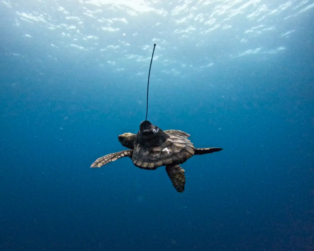
Prior to release, selected juveniles undergo a delicate and non-invasive procedure: the attachment of miniature satellite transmitters. Fastened directly to the center of the turtle’s carapace using specialized marine-grade epoxies, these streamlined, low-profile transmitters are designed to minimize hydrodynamic drag while maximizing battery life and satellite connectivity.
When the turtle surfaces to breathe, the antenna breaks the water’s surface, transmitting a Doppler-shifted signal to an orbiting constellation of Argos satellites. These signals are instantly translated into precise geographical coordinates, providing researchers with a continuous, real-time map of the animal’s dispersal patterns.
Phase Three: Navigating South Africa’s Hope Spots
Upon release into the Indian Ocean coastal waters off South Africa, Tolkien, Mpho, and their cohort immediately face the dynamic, high-energy marine environment of the region. The tracking data reveals that these juveniles do not wander aimlessly; rather, their movements are heavily dictated by regional oceanographic features, particularly the powerful Agulhas Current system.
The tracking maps showcase the turtles traversing designated Hope Spots—special areas of the ocean that are scientifically identified as critical to the health of the marine ecosystem. As the turtles ride these coastal currents, their trajectories offer scientists a living blueprint of how vulnerable pelagic species utilize protected corridors during their dispersal phases.
Phase Four: Venturing into the Open Ocean
As the weeks progress, the miniature satellite tags record the juveniles pushing past the continental shelf and out into the vast, pelagic realm of the open ocean. This is the heart of the "lost years" phase made visible. The data captures erratic loops, sustained directional swimming aligned with thermal fronts, and deep dives—behavioral traits that help researchers pinpoint where high-risk industrial fishing zones intersect with juvenile turtle migration routes.
Supporting Context & Metrics: Unlocking the "Lost Years"
The term "lost years" was coined decades ago to describe the ontogenetic shift in sea turtles from coastal hatchlings to pelagic juveniles, and finally to coastal sub-adults. Historically, marine biologists had virtually no empirical data regarding where these animals went, what water temperatures they preferred, or how long they remained in the open-ocean gyres.
The Technological Leap
The advent of miniaturized satellite telemetry has shattered this data vacuum. Modern tags weigh only a fraction of the turtle’s total body mass, ensuring complete freedom of movement. The metrics captured by these devices include:
- Geographical Coordinates: Pinpointing locations down to tens of meters via Argos and GPS positioning.
- Dive Profiles: Recording the depth and duration of sub-surface dives, revealing foraging and predator-avoidance behaviors.
- Sea Surface Temperature (SST): Correlating turtle movements with thermal boundaries to understand how climate shifts impact pelagic distribution.
Ecological Implications for Hope Spots
South Africa’s Hope Spots—championed globally by Mission Blue—serve as critical sanctuaries within a vast, heavily utilized marine domain. By tracking rehabilitated turtles through these areas, scientists have gathered empirical evidence proving that Hope Spots function as vital biological stepping stones. They provide safe havens where young animals can feed, grow, and build physiological resilience before braving the high seas.
Furthermore, the data collected from Tolkien, Mpho, and other tracked turtles provides conservation planners with the exact spatial metrics needed to lobby governments for expanded marine protected areas (MPAs), stricter bycatch regulations for longline fisheries, and robust international frameworks to combat high-seas plastic pollution.
Official Statements and Collaborative Vision
The success of this tracking initiative is a testament to the power of cross-sector collaboration. Conservationists, aquarists, and technologists have united under a shared banner to amplify the voice of the ocean’s most vulnerable inhabitants.
Dr. Sylvia Earle, legendary oceanographer and founder of Mission Blue, has repeatedly emphasized the profound interconnectedness of marine ecosystems and the urgency of protecting migratory corridors:
"When we look at the journeys of young turtles like Tolkien and Mpho, we are not just observing individual animals; we are looking through a window into the circulatory system of our planet. These turtles connect coastal nurseries with the high seas, reminding us that ocean conservation cannot stop at national borders. Protecting their pathways is essential to safeguarding the future of the blue heart of our planet."
Representatives from the Two Oceans Aquarium Turtle Conservation Centre have highlighted the dual nature of their work—balancing the micro-level care of individual patients with macro-level conservation science:
"Every turtle that comes through our doors represents a second chance, not just for that specific animal, but for marine science as a whole. By working alongside Upwell Turtles and Mission Blue, we are transforming individual rescues into global insights. The data streaming from these satellite tags empowers us to answer questions that have baffled marine biologists for generations."
Upwell Turtles, an organization dedicated to using advanced technology to protect sea turtles throughout their marine life cycles, notes that telemetry is democratizing conservation:
"Technology has leveled the playing field. For years, the open ocean was a black box. Today, thanks to satellite miniaturization and robust partnerships, we can follow a juvenile loggerhead across thousands of kilometers of open water. This transparency allows us to bridge the gap between science and policy, ensuring that decision-makers have the hard data required to implement effective, science-based ocean protections."
Future Outlook: The Road Ahead for Pelagic Conservation
As Tolkien, Mpho, and their fellow travelers continue to transmit data from the deep, the conservation community is already looking toward the horizon. The insights gleaned from this initiative are paving the way for the next generation of marine stewardship.
Scaling Up Tracking Initiatives
Buoyed by the success of the current cohort, project partners are exploring ways to expand the satellite tracking program to include other vulnerable species, such as green turtles (Chelonia mydas) and hawksbills (Eretmochelys imbricata). Scaling up the sample size will yield a more statistically robust dataset, allowing researchers to map multi-species pelagic highways and identify persistent "hotspots" of human-wildlife conflict.
Informing International Policy
The ultimate goal of this StoryMap and its underlying telemetry data is action. Conservation organizations are actively utilizing these findings to engage with regional fisheries management organizations (RFMOs) and international bodies. By demonstrating precisely where juvenile sea turtles spend their time, advocates can push for seasonal gear restrictions, turtle excluder devices (TEDs) in commercial fisheries, and targeted clean-up initiatives in high-accumulation plastic convergence zones.
Engaging the Global Public
Conservation cannot succeed in a vacuum; it requires public resonance and education. Through interactive digital platforms such as the collaborative ArcGIS StoryMap (storymaps.arcgis.com), people around the world can virtually swim alongside Tolkien and Mpho. This direct engagement fosters a deep emotional connection to marine life, transforming passive observers into active advocates for ocean health.
In an era defined by unprecedented environmental challenges, the remarkable odysseys of these rehabilitated loggerheads offer a powerful counter-narrative of hope, resilience, and scientific innovation. As we decode the secrets of the "lost years," we are simultaneously drawing the map toward a more sustainable, fiercely protected ocean future.