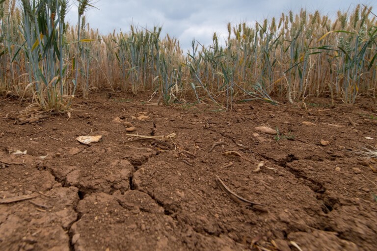
The American Southwest is confronting an unprecedented hydrological emergency as the nation’s two largest man-made reservoirs—Lake Mead and Lake Powell—have plunged to historic record-low water levels within days of each other. Fed by the beleaguered Colorado River, these critical infrastructure assets form the bedrock of water security, agricultural production, and hydroelectric generation across seven U.S. states.
The dual collapse of storage levels across both reservoirs underscores an escalating systemic crisis driven by three intersecting forces: human-induced climate change, rapid regional demographic expansion, and long-standing political inertia surrounding water allocations. Today, approximately 40 million people rely on the Colorado River basin for municipal water, while its flows irrigate roughly 5.5 million acres (22,258 square kilometers) of agricultural land that feeds much of the nation.
With combined storage capacity reduced to a fraction of historical norms, water resource managers face an agonizing dilemma. As the region enters the late summer and autumn months with no guarantee of winter precipitation, experts warn that the window to restructure water management policies and prevent structural failure of the basin’s supply grid is rapidly closing.
Detailed Chronology of the Crisis
The trajectory of the Colorado River system has transitioned from a managed deficit to an active crisis over the past two decades, culminating in sequential record lows recorded in August.
+-------------------------------------------------------------------------+
|                       RESERVOIR CAPACITY COMPARISON                     |
+-------------------------------------------------------------------------+
| LAKE MEAD                                                               |
| Max Full Pool: 347.60m ======================================= (100%)   |
| Aug 7 Record:  317.11m =================== (Severely Depleted)          |
+-------------------------------------------------------------------------+
| LAKE POWELL                                                             |
| Max Full Pool: 1,127.76m ===================================== (100%)   |
| Aug 15 Record: 1,072.87m ================= (Severely Depleted)          |
+-------------------------------------------------------------------------+
The Falling of Lake Mead
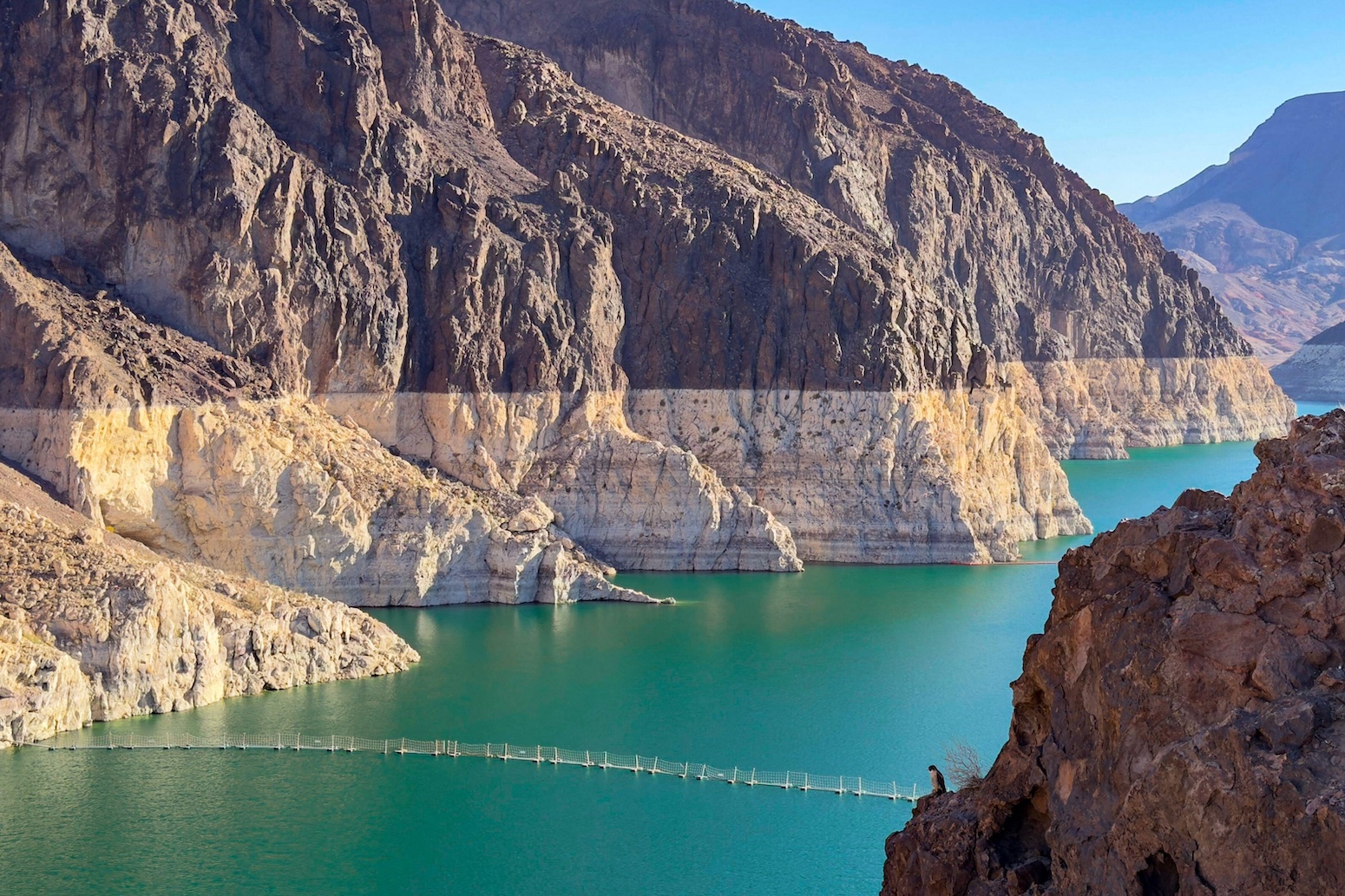
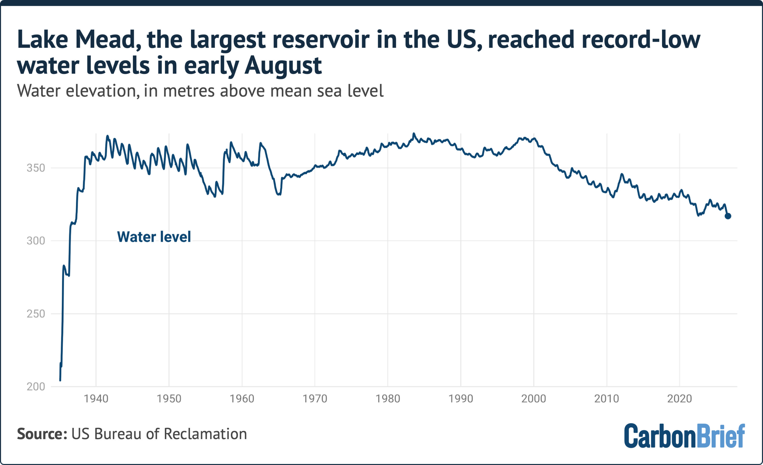
Lake Mead, impounded by the Hoover Dam in 1935, serves as the primary Lower Basin reservoir. Designed with a "full pool" elevation of 347.60 meters above mean sea level, the reservoir has experienced a steady decadal decline. On August 7, water levels plummeted to a new historic low of 317.11 meters. This milestone breached previous record minimums, signaling that the lower reservoir’s active storage is contracting at a rate faster than regulatory models had anticipated.
The Decline of Lake Powell
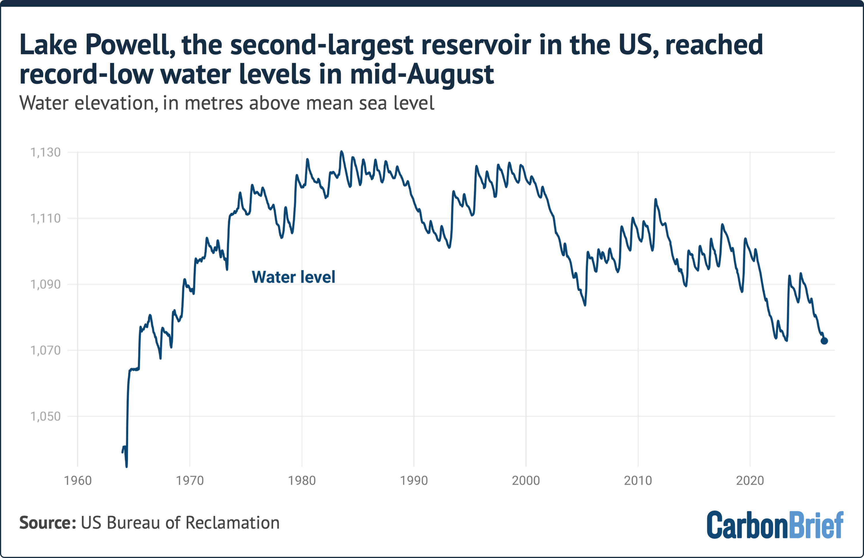
Just eight days later, upstream at Lake Powell—created by the construction of the Glen Canyon Dam in the 1960s—the crisis deepened. Lake Powell’s full-pool capacity stands at 1,127.76 meters above mean sea level. While the reservoir repeatedly reached full capacity during wet cycles in the 1980s, it has not approached those levels in the 21st century. On August 15, Lake Powell’s elevation dropped to an all-time low of 1,072.87 meters.
The Seasonal Depletion Window
Hydrological experts note that both reservoirs are projected to continue their downward trajectory through the remainder of the summer, autumn, and winter. The regional hydrological cycle relies heavily on high-altitude snowpack accumulation in the Upper Colorado River Basin during the winter months, which does not begin to melt and recharge the river network until early spring—typically around April. Consequently, total basin reservoir storage will undergo relentless net depletion for at least eight consecutive months without significant upstream inflow.
Supporting Context & Hydrological Metrics
Understanding the scale of the current depletion requires examining the massive physical dimensions and operational responsibilities of the Colorado River system.
+-------------------------------------------------------------------------+
|                     COLORADO RIVER BASIN AT A GLANCE                    |
+-------------------------------------------------------------------------+
|  Combined Maximum Storage  | 68 cubic kilometers (68 billion m³)        |
|  Equivalent Water Supply   | ~1.5 years of total U.S. household use      |
|  Population Dependent      | 40 Million (up 60% / +15M since 1992)      |
|  Agricultural Footprint     | 5.5 Million Acres (22,258 km²)              |
|  Upper River Flow Loss     | -20% since 1900 (~50% due to climate change)|
+-------------------------------------------------------------------------+
Storage Demographics and Consumption Demands
At maximum capacity, Lakes Mead and Powell can hold a combined 68 cubic kilometers (68 billion cubic meters) of water. This volume is theoretically sufficient to satisfy total domestic household consumption across the entire contiguous United States for nearly 1.5 years.
However, structural over-allocation combined with environmental stress has gutted this buffer. The demand footprint on the river has expanded significantly over recent decades:
Population Growth: Since 1992, the number of people relying on the Colorado River for all or part of their municipal supply has increased by 15 million—a 60% surge that brings the total dependent population to roughly 40 million. Major metropolitan areas including Los Angeles, Phoenix, Las Vegas, Denver, and Salt Lake City draw heavily from the river or its tributaries.
Agricultural Requirements: The river provides vital irrigation for 5.5 million acres (22,258 square kilometers) of agricultural land across Arizona, California, Colorado, New Mexico, Nevada, Utah, and Wyoming. This acreage yields a major portion of the nation’s winter produce, forage crops like alfalfa, and high-value livestock support.
The Mechanics of Flow Reduction
The baseline yield of the river is shrinking. Since the turn of the 20th century, the volume of water flowing along the Upper Colorado River has decreased by approximately 20%.
Rigorous attribution studies indicate that at least half of this 20% decline is directly attributable to human-induced climate change. Higher average temperatures increase evapotranspiration rates, dry out mountain soils, and cause winter snowpacks to sublime directly into the atmosphere or soak into arid ground before ever reaching stream channels.
The 25-Year Megadrought
The Southwestern U.S. is currently enduring a historic "megadrought" that has persisted for over a quarter of a century—the driest multidecadal period in the region in more than 1,200 years. Climate research analyzing the period from 2000 to 2018 concluded that anthropogenic global warming accounted for nearly 47% of the megadrought’s overall severity. The prolonged lack of precipitation, combined with record-setting summer heatwaves, has systematically drained the region’s natural hydrological reserves.
Official Statements & Policy Perspectives
The dramatic drop in water levels has highlighted the gap between natural hydrological realities and the governance frameworks that regulate water allocation among the basin states.
Scientific Analysis: Ultimate vs. Proximate Causes
Dr. Jack Schmidt, a senior research scientist at Utah State University’s Center for Colorado River Studies, emphasizes that the crisis must be understood through both environmental and political lenses.
"The big dilemma of the moment is that we’re only in the middle of August, and we have no assurance of what the coming winter will be," Dr. Schmidt stated. "The only thing we can be sure of is that we will be depleting overall total basin reservoir storage from now until, roughly, early April."
Dr. Schmidt highlights the distinct mechanisms driving the emergency:
"There’s an ultimate cause of the present water crisis, and there’s a proximate cause. The ultimate cause is a warming climate, a warming planet and a pretty clear correlation between warming conditions and decreased runoff in the Colorado River Basin.
The proximate cause is that in this messy democratic republic of ours, big policy decisions that match the variability of the climate occur painfully slowly—with intense political negotiations—and only incrementally."
                    +------------------------------------+
                    |     THE DUAL CAUSES OF CRISIS      |
                    +------------------------------------+
                                      |
         +----------------------------+----------------------------+
         |                                                         |
         v                                                         v
+-----------------------------------+     +-----------------------------------+
|          ULTIMATE CAUSE           |     |          PROXIMATE CAUSE          |
|  - Warming global temperatures    |     |  - Slow political negotiations    |
|  - Reduced snowpack & runoff      |     |  - Incremental policy changes     |
|  - Increased evapotranspiration   |     |  - Outdated water rights laws     |
+-----------------------------------+     +-----------------------------------+
Federal Regulatory Intervention
On July 31, the U.S. Bureau of Reclamation—the federal agency tasked with managing water infrastructure across the western states—released a pivotal Environmental Impact Statement (EIS). This document serves as the foundational framework for developing operational guidelines post-2026, when the current interim rules governing Lake Mead and Lake Powell are set to expire.
While the formal post-2026 operational strategy remains under development, the EIS outlines potential pathways that grant the federal government broader authority to impose mandatory delivery cuts on basin states during severe shortages.
However, analysts caution that administrative flexibility alone cannot overcome persistent aridity. Dr. Schmidt noted that while the Bureau’s proposed frameworks attempt to build in crisis-response capabilities:
"They acknowledge it won’t work if we just stay critically dry, and of course every climate model for the 21st century, especially with a continually warming planet, says that that’s exactly what’s going to happen."
Future Outlook & Systemic Risk
As the Southwestern states approach crucial negotiations for post-2026 allocations, the physical infrastructure of the Colorado River system approaches dangerous operational thresholds.
+-------------------------------------------------------------------------+
|                        RESERVOIR THREAT MATRIX                          |
+-------------------------------------------------------------------------+
| CRITICAL LEVEL  | PHYSICAL IMPACT                                       |
+-----------------+-------------------------------------------------------+
| Minimum Power   | Water drops below hydroelectric turbine intakes.      |
| Pool            | Power generation ceases; grid destabilizes.           |
+-----------------+-------------------------------------------------------+
| Dead Pool       | Water falls below lowest outlet tubes.                |
|                 | Downstream flow halts; severe water cutoffs begin.    |
+-----------------+-------------------------------------------------------+
The Threat of "Dead Pool" and Hydroelectric Failure
If water levels in Lakes Mead and Powell continue to decline, both reservoirs face two cascading operational risks:
Minimum Power Pool: The elevation below which water can no longer pass through the intake structures to generate hydroelectricity. Glen Canyon Dam (Lake Powell) and Hoover Dam (Lake Mead) generate billions of kilowatt-hours of clean electricity annually, powering millions of homes and businesses across the Southwest. Falling below minimum power pool elevations would cause power generation to cease, threatening regional electrical grid stability.
Dead Pool: The point at which water levels fall below the lowest outlet pipes, rendering the dams physically incapable of releasing water downstream via gravity. Reaching dead pool at Lake Powell would sever water delivery to Lake Mead and the Lower Basin states, triggering catastrophic municipal shortages and environmental collapse along the lower river corridor.
Climate Projections and Necessary Adaptations
Twenty-first-century climate modeling consistently indicates that the Colorado River Basin will continue to experience reduced precipitation efficiency, reduced winter snowpack, and higher mean temperatures. The assumption that the region will experience a sustained return to 20th-century average flows is increasingly rejected by hydrological scientists.
To adapt to this permanent shift toward aridity, state governments, agricultural districts, and municipal water authorities must prepare for structural reductions in their water allocations. Achieving long-term balance will require aggressive urban conservation, agricultural water recycling, crop shifting, and potentially the fallowing of low-yield farmland.
Without fundamental, long-term reductions in consumption that match the river’s warming climate, the short-term record lows observed at Lake Mead and Lake Powell in August will serve merely as precursors to a much larger infrastructure and environmental crisis across the American West.