Indonesia’s Ministry of Forestry has implemented sweeping new restrictions on access to critical geospatial data, igniting intense concern among environmental scientists, human rights advocates, and legal scholars. Under the newly enforced policies, visitors to the ministry’s interactive mapping platform—known as SIGAP—are greeted with a stringent legal disclaimer. The notice warns that the platform is strictly "view-only" and that downloading or extracting raw spatial data without explicit written authorization is a criminal offense prosecutable under Indonesia’s controversial 2008 Electronic Information and Transactions (ITE) Law.
Violators face severe penalties, including up to nine years in prison and fines of up to Rp 3 billion ($170,000 USD). While the Ministry of Forestry defends the policy as a vital measure to curb illegal data trading, prevent geospatial manipulation, and safeguard national resource integrity, critics argue that the move systematically dismantles public accountability. By walling off precise shapefiles (.SHP) behind opaque, discretionary bureaucratic approval processes—while outright excluding non-governmental organizations (NGOs)—the government risks blinding the very civil society actors who track illegal deforestation, monitor carbon emissions, and protect the habitats of critically endangered species such as the Sumatran orangutan (Pongo abelii).
Legal experts contend that the ministry’s interpretation of the ITE Law constitutes a severe overreach, directly conflicting with Indonesia’s constitutional guarantees and the 2008 Public Information Disclosure Act. This development revives longstanding tensions between conservationists and Indonesian authorities over transparency, echoing past crackdowns on independent researchers and non-profit watchdogs.
Detailed Chronology of the Policy Shift
The tightening of geospatial data access marks a quiet yet profound administrative pivot within Indonesia’s environmental governance structure. The timeline leading up to the current restrictions highlights a rapid shift from open public access to criminalized gatekeeping:
Mid-2024: Amid transitions in ministerial leadership—with Minister Raja Juli Antoni taking office—early signs of dialogue and incremental transparency, such as the release of updated wildlife conservation plans, fostered cautious optimism among conservation groups.
Late August to Early September 2026: Users attempting to access the Ministry of Forestry’s SIGAP interactive mapping portal begin encountering an abrupt pop-up notification. The legal disclaimer mandates that visitors agree to restrictive terms and conditions, explicitly citing the punitive measures of the ITE Law for unauthorized data extraction.
September 21, 2026: The Directorate General of Forestry Planning formalizes the administrative hurdles by publishing an instructional video on Instagram. The broadcast outlines a centralized application process requiring prospective users to formally disclose detailed research aims and submit extensive supporting documentation before accessing restricted data layers.
Late September 2026 to Present: Independent GIS analysts, environmental NGOs, and academic researchers report widespread operational friction. While PDF and JPEG visualizations remain viewable, the core analytical assets—specifically raw vector shapefiles essential for accurate geospatial modeling—are officially designated as restricted, available only to universities and government bodies under stringent, discretionary review.
Supporting Context & Metrics: Why Geospatial Data Matters
Geospatial data serves as the digital foundation of modern conservation science, land-use planning, and environmental justice. Platforms like SIGAP allow researchers, Indigenous communities, and watchdogs to overlay multiple complex data layers—including forest cover, fire hotspots, groundwater levels, and official ministerial zoning designations—with millimeter-level precision.
At the heart of the technical dispute is the shapefile (.SHP) format. Unlike flat image files (such as JPEGs or PDFs), which are static and highly susceptible to distortion when manually digitized, shapefiles contain embedded digital signatures and coordinate systems. This architecture enables researchers to accurately evaluate whether a commercial mining or palm oil enterprise is illegally encroaching on protected forests, infringing upon Indigenous customary lands, or degrading critical wildlife corridors.
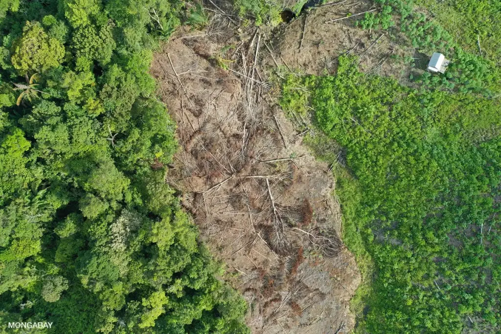
One focal point of this monitoring is the Rawa Singkil Wildlife Reserve in Aceh province. Often described as the "orangutan capital of the world," this fragile peat swamp ecosystem provides a vital sanctuary for the critically endangered Sumatran orangutan. Conservation NGOs, such as HAkA, have historically relied on open SIGAP data to document illegal forest clearance and conversion inside the reserve.
Without frictionless access to precise geospatial datasets, civil society organizations lose their real-time capability to independently verify corporate sustainability claims, audit government land concessions, and hold bad actors accountable for environmental degradation.
Official Statements and Competing Perspectives
The Ministry’s Defense: Security and Data Integrity
Defending the policy, Doni Prabowo, head of forest monitoring and geospatial information at the Directorate General of Forestry Planning, asserted that the restrictions are a necessary corrective to years of unregulated, uncontrolled data distribution. According to Prabowo, unchecked access created dangerous vulnerabilities, including the potential for bad actors to manipulate zoning data or commercially trade government-owned information on online marketplaces.
"What if somebody manipulates the data and says certain areas are not protected forest [when they really are]? It could be dangerous," Prabowo stated in an interview.
Prabowo firmly denied that the ministry intends to suppress scientific inquiry, emphasizing that the department remains open to diverse analytical perspectives. He clarified that the restrictions apply exclusively to raw shapefiles, while summary visualizations and PDF documents remain freely downloadable without prior approval. Furthermore, Prabowo outlined that universities and state-affiliated institutions can still acquire raw shapefiles through the formal application portal. However, NGOs face a different path: if non-profits wish to analyze raw data, they must either digitize visual formats independently or submit a formal request for the ministry to perform the analysis on their behalf.
Civil Society and Legal Pushback: Censorship and Overreach
Environmental advocates and legal scholars view the ministry’s concessions as impractical and fundamentally hostile to independent oversight. Andreas Harsono, a Jakarta-based researcher for Human Rights Watch, characterized the policy as a textbook example of bureaucratic obstructionism.
"It’s a typical Indonesian approach," Harsono observed. "It does not say that you cannot download the data, but you need to get a permit to download government data. These permits are usually very long to get, taking so much time, if approved at all. It shows that the Ministry of Forestry does not have the goodwill to provide maps. It’s going to complicate land management in Indonesia as well as increase corruption opportunities."
Legal authorities argue that the ministry’s threats under the ITE Law have no grounding in statutory reality. Herlambang Wiratraman, a constitutional law professor at Gadjah Mada University, emphasizes that public access to geospatial data is firmly protected under the 2008 Public Information Disclosure Act and the constitutional amendments passed following the 1998 fall of President Suharto. These legal frameworks guarantee citizens the fundamental right to seek, obtain, and process information necessary for social and environmental development.
Laode Syarif, a senior lecturer at Hasanuddin University Law School and former deputy head of Indonesia’s Corruption Eradication Commission (KPK), concurred, noting that the ITE Law was never designed to criminalize the downloading of public datasets unless accompanied by malicious intent to deceive or commit fraud.
"If they use the data and present it the way it is, then there’s no problem with it. It’s a different case if they lie," Syarif noted. "Geospatial data is an essential tool for fighting environmental crime… Our country needs it. And by country, I mean the country itself. Not only the government, but most importantly the public itself. Without them, a country does not exist."
Future Outlook and Implications for Indonesian Democracy
The clampdown on SIGAP data revives memories of previous administrations characterized by defensive information control. Past controversies under former President Joko Widodo’s tenure included the blacklisting of foreign scientists, the deportation of wildfire researchers, and protracted legal battles against NGOs seeking corporate concession maps—battles that culminated in Supreme Court defeats for the Ministry of Forestry.
While recent months had shown promising signs of administrative openness under Minister Raja Juli Antoni—highlighted by regularized dialogues and updated wildlife population assessments—the sudden weaponization of the ITE Law against geospatial users threatens to undo this fragile progress.
As Indonesia balances its international climate commitments, biodiversity preservation goals, and economic development objectives, the availability of transparent, verifiable data remains paramount. Observers warn that by erecting legal and bureaucratic moats around public geographic information, the government risks undermining its own anti-corruption agenda, stifling academic innovation, and eroding the foundational trust necessary for a healthy, participatory democracy.