

By Global Environmental and Geopolitical Desk
Published: October 2023
Produced by Tom Joyner | Graphics by Mesut Ersoz and Leo Scutt-Richter
Executive Overview
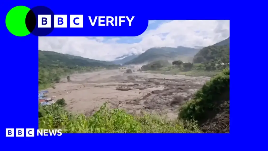
In the high-altitude reaches of the Himalayas, where the rugged borders of Nepal and the Tibet Autonomous Region converge, a catastrophic natural disaster has left a trail of destruction, loss of life, and profound ecological anxiety. Recent devastating flash floods, which tore through remote mountain valleys with terrifying speed, have now been definitively linked by glaciologists and geomorphologists to a massive, sudden glacier collapse.
The geological failure occurred north of Langtang Lirung, a formidable Himalayan peak soaring more than 7,000 meters above sea level. While preliminary assessments point toward a catastrophic structural failure of the ice mass—potentially catalyzed or exacerbated by a massive, high-elevation rockslide—the exact ignition sequence remains under intense scientific scrutiny.
This disaster is not an isolated anomaly. Rather, it serves as a terrifying bellwether for the escalating vulnerabilities facing high-mountain Asia. As global temperatures rise at rates significantly higher than the planetary average, the cryosphere—the frozen water part of the Earth system—is undergoing unprecedented destabilization. The resulting Glacial Lake Outburst Floods (GLOFs) and direct ice-rock avalanches pose an existential threat to downstream communities, critical infrastructure, and millions of lives across South Asia. This report synthesizes the latest scientific findings, details the chronology of the disaster, contextualizes the broader systemic risks, and outlines the urgent policy and mitigation measures required to prevent future catastrophes.
Detailed Chronology of the Disaster
Reconstructing the exact timeline of a disaster in the remote, highly inaccessible terrain of the high Himalayas is a complex undertaking, relying heavily on satellite telemetry, seismic monitoring networks, and delayed ground reports from local authorities.
Phase 1: Precursor Conditions and Seismic Silence
In the weeks leading up to the disaster, the Langtang and surrounding Himalayan sub-ranges experienced unseasonal weather patterns characterized by localized temperature spikes and fluctuating precipitation levels. Unlike earthquakes, which announce themselves with violent seismic signatures, mass movements of glacial ice and high-altitude rock masses often provide little to no warning. Seismic monitoring stations recorded low-frequency tremors, but these were initially dismissed as routine ice cracking or micro-avalanches common to the region’s dynamic topography.
Phase 2: The Collapse at Langtang Lirung
The critical event occurred on the northern flanks of Langtang Lirung. According to preliminary remote-sensing data analyzed by international research teams, a colossal section of the high-altitude glacier detached from its bedrock.
Leading glaciologists suggest two primary mechanisms for the collapse:
- Internal Hydrological Pressure: The accumulation of meltwater within internal glacial cavities (englacial channels) creating hydrostatic pressure high enough to fracture the ice.
- Massive Rock-Ice Avalanche: A destabilized rock wall above or adjacent to the glacier failing catastrophically, bringing millions of tons of stone and ice down onto the glacier tongue, shattering the ice structure and carrying it down-slope.
The sheer kinetic energy of the collapse obliterated everything in its immediate path, transforming millions of cubic meters of solid ice, pulverized rock, and debris into a liquefied, high-velocity slurry.
Phase 3: The Downstream Surge
Channelized by narrow mountain gorges, the debris-laden torrent rushed downward into river systems feeding both the Nepalese and Tibetan valleys. The sudden displacement of water and ice overwhelmed natural river channels within minutes.
Eyewitnesses in downstream settlements described a sudden, deafening roar akin to a low-flying jet engine, followed immediately by a wall of muddy water, boulders, and pulverized ice. Bridges were swept away like matchsticks, hydroelectric micro-plants were crushed, and agricultural terraces were buried under meters of grey silt and debris.
Phase 4: Emergency Response and Initial Assessments
As communication lines were severed and roads washed out, emergency response teams faced monumental hurdles in reaching affected communities. Search and rescue operations, coordinated jointly by Nepalese authorities and regional disaster management agencies, deployed helicopters to pluck stranded survivors from isolated ridges.
Concurrently, international scientific consortiums began tasking high-resolution Earth-observation satellites—including European Space Agency (ESA) and NASA spacecraft—to capture before-and-after imagery of the Langtang Lirung face, confirming the massive scar left by the departed ice mass.
Supporting Context & Metrics: The Thriving Crisis in High-Mountain Asia
To fully comprehend the mechanics of the Langtang Lirung disaster, one must examine the broader environmental metrics defining the Hindu Kush Himalaya (HKH) region, frequently designated by climatologists as the "Third Pole."
Rising Temperatures and Cryospheric Retreat
The HKH region is warming at a rate significantly faster than the global land-average. According to comprehensive assessments by the International Centre for Integrated Mountain Development (ICIMOD):
- Accelerated Melting: Glaciers in the Himalayas could lose up to 80% of their current volume by the end of the century if global greenhouse gas emissions continue on their current trajectory.
- Permafrost Degradation: High-altitude permafrost, which acts as a natural cement holding steep rock walls and glacial moraines together, is thawing rapidly. This structural thawing compromises the integrity of mountain slopes worldwide, dramatically increasing the frequency of catastrophic rockfalls and landslides.
The Geography of Vulnerability
The topography of Nepal and Tibet creates a perilous juxtaposition of extreme relief and dense human habitation. River valleys such as the Langtang Valley—tragically remembered for the massive losses sustained during the 2015 Nepal earthquake—are narrow funnels. When an upstream blockage fails or an ice-rock avalanche enters a watercourse, the resulting flood wave retains its destructive energy over astonishingly long distances, crossing international borders and catching communities entirely off-guard.
Comparative Metrics of Himalayan Disasters
| Event / Location | Primary Trigger | Estimated Volume of Material | Downstream Impact |
|---|---|---|---|
| Chamoli Disaster (India, 2021) | Rock-ice avalanche | ~27 million cubic meters | Destruction of two hydroelectric projects; 200+ casualties. |
| Melamchi Flood (Nepal, 2021) | Debris flow / Landslide dam | Variable | Severe infrastructure damage; long-term displacement. |
| Langtang Lirung (Current Event) | Glacier collapse / Rockslide | Millions of cubic meters | Widespread flooding across Nepal-Tibet border; extensive property and environmental damage. |
Official Statements and Expert Analysis
The disaster has triggered urgent statements from governmental bodies, international scientific organizations, and geological institutes demanding a coordinated cross-border response.
Scientific Consensus: Mark Poynting and Glaciology Experts
Reporting on the disaster, environmental journalists like Mark Poynting have highlighted the profound uncertainties that still plague high-altitude hazard forecasting. While the physical evidence clearly points to a structural failure originating near Langtang Lirung, pinning down the exact trigger remains a formidable scientific challenge.
Dr. Arpita Mondal, a hydrologist specializing in Himalayan water systems, noted in a recent briefing:
"We are witnessing a fundamental shift in the stability of high-mountain cryospheric systems. Traditional hazard maps, which rely on historical hydrological data from the 20th century, are no longer valid. The combination of intense localized thermal stress, internal glacier melting, and slope destabilization creates a ticking clock for downstream valleys."
Governmental Responses: Nepal and Tibet
In Kathmandu, disaster management authorities convened emergency sessions to evaluate the structural integrity of other high-risk glacial lakes and unstable ice masses across the Nepalese Himalaya. The Ministry of Home Affairs issued nationwide advisories urging communities living near major river basins—particularly the Trishuli, Sun Koshi, and Arun rivers—to maintain heightened vigilance.
In Beijing and the Tibet Autonomous Region, emergency management bureaus mobilized geological survey teams to conduct aerial and ground-based assessments of transboundary river flows. Chinese authorities emphasized the critical importance of real-time hydrometeorological data sharing between upstream and downstream nations, recognizing that natural hazards in the Himalayas do not respect geopolitical borders.
Future Outlook: Mitigation, Adaptation, and Resilience
The disaster at Langtang Lirung is a stark warning that demands a fundamental paradigm shift in how regional governments and the international community approach high-mountain risk management.
1. Upgrading Early Warning Systems (EWS)
Traditional siren-based warning systems are inadequate for sudden-onset ice avalanches and glacier collapses, which travel at blistering speeds. Future resilience relies on the deployment of:
- Acoustic Flow Monitors: Sensors placed along riverbeds that detect the low-frequency rumble of approaching debris flows before they arrive.
- AI-Powered Satellite Monitoring: Automated machine-learning models trained to scan daily satellite imagery for subtle surface deformations, tension cracks, and abnormal movement in glacial tongues.
2. Transboundary Data Integration
Rivers originating in the Tibetan Autonomous Region flow southward into Nepal and India, making hydrology a uniquely international security concern. Effective disaster risk reduction requires robust, unhindered sharing of meteorological and hydrological data in real-time, insulated from broader geopolitical tensions.
3. Sustainable Infrastructure and Managed Retreat
Hydroelectric projects, roads, and human settlements constructed in narrow Himalayan gorges must be subjected to rigorous, climate-informed environmental impact assessments. In extreme cases, managed retreat—relocating vulnerable communities from high-risk alluvial fans and narrow floodplains to safer, elevated terrain—must be considered by policymakers, supported by international climate adaptation funds.
Conclusion
The catastrophe triggered by the glacier collapse north of Langtang Lirung is a chilling reminder of the raw, untamed power of the world’s highest mountain range. As climate change continues to rewrite the physical rules governing the Himalayas, disasters of this nature will likely increase in frequency and severity.
Only through a combination of cutting-edge scientific monitoring, transparent cross-border cooperation, and aggressive global climate action can the nations of the Hindu Kush Himalaya protect their populations from the cascading fury of a melting cryosphere. The time for reactive disaster management has passed; the era of proactive, climate-resilient adaptation must begin now.



