

Executive Overview
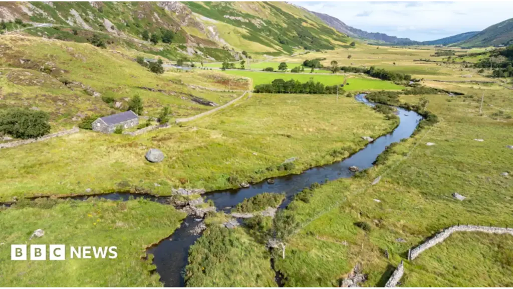
High in the dramatic, glacier-carved expanses of Eryri National Park—historically and internationally recognized as Snowdonia—a silent crisis is unfolding. Conservationists, ecologists, and local land managers have issued a dire warning: some of Wales’ most fragile, iconic, and endangered species are at immediate risk of permanent local extinction. The rugged landscapes of the Nant Ffrancon valley, stretching from the towering crags of Cwm Idwal down to the sweeping floor of Dyffryn Ogwen, are suffering from profound and systemic ecological decline. Once teeming with a rich mosaic of unique upland biodiversity, these ancient habitats are now buckling under the twin pressures of historical overgrazing, habitat fragmentation, and the accelerating impacts of global climate change.
In response to this escalating nature emergency, a major £1 million rescue initiative has been officially launched. Spearheaded by the National Trust in close collaboration with the Welsh government, the Heritage Fund, Natural Resources Wales, tenant farmers, and local volunteers, the ambitious scheme aims to restore, protect, and future-proof more than 4,000 acres of sensitive upland terrain.
This comprehensive conservation intervention represents far more than a routine environmental cleanup; it is a meticulously coordinated rescue mission designed to halt the unraveling of one of the United Kingdom’s most treasured natural landscapes. Utilizing cutting-edge technology—such as GPS-enabled virtual fencing for livestock—alongside traditional ecological stewardship and deep community engagement, the project aims to reverse decades of degradation. By doing so, project leaders hope to establish a resilient, self-sustaining foundation for biodiversity that will endure for generations, ensuring that the haunting calls of rare mountain birds and the delicate blooms of fragile alpine flora are not lost to history.
Detailed Chronology: From Glacial Marvels to Ecological Crisis
To understand the urgency of the current intervention, one must examine the deep historical and ecological trajectory of the Nant Ffrancon valley. Formed thousands of years ago by the relentless grinding of glacial ice, the valley evolved into a complex ecosystem defined by towering cliffs, scree slopes, fast-flowing rivers, and nutrient-poor upland bogs. These harsh yet remarkably biodiverse microclimates supported species uniquely adapted to the rigors of high-altitude Welsh weather.
For centuries, the landscape maintained a delicate equilibrium. Traditional farming practices, particularly extensive sheep and cattle grazing, helped shape the open vistas. However, over the past century, socioeconomic pressures, agricultural intensification, and a lack of holistic environmental management disrupted this balance. Livestock numbers surged beyond the carrying capacity of fragile moorlands and delicate peat soils, leading to widespread overgrazing, the suppression of native woodland regeneration, and the severe erosion of sensitive slopes.
As native flora—such as ancient upland woodlands of aspen and juniper—disappeared, the structural complexity of the habitat collapsed. This degradation directly triggered a domino effect up the food chain. Specialized insect populations plummeted, leaving high-altitude insectivorous birds without adequate food sources.
Over the past two decades, field naturalists and National Trust rangers noted alarming downward trends in indicator species. Populations of the ring ouzel (often colloquially referred to as the mountain blackbird) and the mountain finch experienced catastrophic declines. Once familiar sights and sounds of the Eryri uplands, these avian specialists began vanishing from their historic strongholds.
Recognizing that localized efforts were no longer sufficient to combat systemic landscape failure, conservation scientists spent the early 2020s drafting a unified regional strategy. This groundwork culminated in the securement of nearly £1 million in capital from the Nature Networks Fund—administered by the Heritage Fund on behalf of the Welsh government and Natural Resources Wales. This influx of capital marks the official commencement of the modern restoration era in Eryri, shifting the paradigm from passive observation to aggressive, tech-enabled habitat rehabilitation.
Supporting Context & Metrics: The Anatomy of a Landscape in Peril
The geographic scope of the newly funded initiative is vast, encompassing a staggering 4,040 acres of high-priority conservation land within Eryri National Park. Within this footprint lie some of the most ecologically sensitive and scientifically significant habitats in the United Kingdom, necessitating a precision-based approach to land management.
The Scale of the Intervention
- Total Acreage Targeted: 4,040 acres (approx. 1,635 hectares) across Nant Ffrancon, Cwm Idwal, and Dyffryn Ogwen.
- Financial Investment: Nearly £1 million delivered via the Nature Networks Fund.
- Core Partners: The National Trust, Natural Resources Wales, the Heritage Fund, Plantlife Cymru, local tenant farmers, and regional volunteer networks.
- Key Species Monitored: Ring ouzel (Turdus torquatus), woodcock (Scolopax rusticola), otter (Lutra lutra), mountain finch populations, and rare alpine flora.
- Target Botanical Indicators: Native tree and shrub species including aspen (Populus tremula) and juniper (Juniperus communis).
The Technology of Conservation: GPS Livestock Collars
One of the most innovative and scientifically rigorous components of the £1M scheme is the integration of advanced agricultural technology to solve a centuries-old ecological dilemma: how to graze livestock for the benefit of the land rather than its detriment.
Historically, traditional fencing in steep, mountainous terrain is difficult to erect, expensive to maintain, and often hazardous to wildlife. Unmanaged, free-roaming livestock frequently concentrate in over-sensitive riparian zones or fragile alpine meadows, trampling rare vegetation and accelerating soil erosion.
The new project scales up the deployment of innovative GPS-enabled livestock collars. These devices allow conservationists and tenant farmers to establish invisible, digital boundaries across the landscape. The collars interact with cattle via audio and mild stimulus cues, gently guiding them away from recovering habitats and toward areas that benefit from targeted grazing.
This precision management allows farmers to control grazing density, timing, and location with unprecedented accuracy. Crucially, live data streams directly to smartphones and applications used by the farmers on the ground. This real-time feedback loop ensures that conservation grazing becomes an active tool for habitat restoration—reducing scrub encroachment where necessary, maintaining sward diversity, and preventing the over-compaction of fragile upland soils.
Official Statements and Expert Perspectives
The gravity of the situation has drawn stark warnings from leading environmental authorities, who emphasize that the window for meaningful intervention is rapidly closing.
Simon Rogers, speaking on behalf of the National Trust, laid bare the stark reality facing the region during the project’s launch:
"We’re in a very serious situation—we’re in a nature emergency. There are so many species in this valley which are on the brink of extinction. We have a unique variety of habitats here, but many of the species that define this landscape really are on the brink. What we’re trying to do with this project is set a foundation for the future. Some things will change in the next three years, but what we’re doing is setting ourselves up so that recovery can continue for decades afterwards."
The initiative also integrates vital botanical conservation through specialized partnerships. Among the beneficiary projects is Tlysau Mynydd Eryri (Mountain Jewels of Eryri), a collaborative conservation effort led by Plantlife Cymru aimed at safeguarding the future of Wales’ rarest alpine plants. These botanical treasures, clinging to high, wind-swept ledges, are exceptionally vulnerable to changing climatic conditions and shifting competitive pressures from more aggressive, lowland plant species.
Rhys Wheldon-Roberts, Cwm Idwal Partnership Officer, underscored the critical importance of ecological monitoring and community involvement in achieving long-term sustainability:
"Monitoring is really important because it allows us to graze in the right areas at the right densities and at the right time. The collars on the cattle allow us to move them around the landscape, and you can monitor it as you go, with farmers seeing that data live on their apps. It can make grazing something much more effective for the cattle and for nature."
Wheldon-Roberts also emphasized the educational and social dimensions of the project, noting that safeguarding a landscape requires cultivating a deep-seated cultural appreciation for it:
"There are opportunities for people to get involved in monitoring, in volunteering, just learning about the landscape in general. Here in Cwm Idwal, we have lots of school visits every year, and they’ll be able to see the effects of the project and the impact that the cattle are having in that conservation grazing way, so it’s really exciting in that regard as well. By bringing people along with us, they get a chance to learn and hopefully appreciate, and ultimately try to protect, this special landscape that we’ve got around us."
Future Outlook: A Multi-Decade Blueprint for Eryri
The launch of the £1 million Nature Networks Fund project in Nant Ffrancon marks a turning point, but conservation leaders are quick to emphasize that halting ecological decline is a marathon, not a sprint. The funded interventions are structured around a rigorous three-year implementation window, but their true design is intended to ripple outward across decades.
Key Milestones for the 3-Year Horizon:
- Habitat Stabilization (Months 1–12): Deployment of GPS collar networks, baseline ecological surveys across all 4,040 acres, and establishment of community volunteer frameworks.
- Vegetation and Fauna Recovery (Months 12–24): Active monitoring of indicator species (ring ouzel, woodcock, otter) alongside targeted planting of native aspen and juniper woodlands to restore structural diversity.
- Long-Term Framework Integration (Months 24–36+): Assessment of grazing efficacy via live app telemetry, expansion of educational outreach programs with regional schools, and transition of the management model into a self-sustaining community-farmer cooperative framework.
Ultimately, the success of the Eryri restoration project will serve as a bellwether for upland conservation across the United Kingdom. As national parks face mounting pressures from climate volatility, tourism, and shifting agricultural subsidies, the ability to harmonize modern technological innovation with traditional land stewardship will determine whether wild landscapes survive or succumb.
In Nant Ffrancon, the race is officially underway. Through the synergy of digital precision, scientific rigor, and deep-rooted community passion, conservationists are striving to ensure that the timeless peaks of Eryri do not fall silent, preserving their breathtaking biodiversity for the generations yet to come.



