

Executive Overview
In the rolling landscapes of Sussex, a quiet ecological renaissance is taking root. A dedicated coalition of conservationists, community volunteers, and environmental charities has achieved a major milestone in the ongoing mission to safeguard the region’s botanical heritage. The ambitious initiative known as the "Lost Woods" project has successfully recorded more than 5,500 ancient, veteran, and notable trees across a sprawling 121-square-mile (314-square-kilometer) corridor stretching from Lewes to Storrington.
Launched formally in March 2024 with backing from the National Lottery Heritage Fund, the project represents a collaborative effort among four of the United Kingdom’s foremost environmental and rural organisations: the Woodland Trust, Action in Rural Sussex, the Sussex Wildlife Trust, and the Small Woods Association. Together, these entities form the backbone of a multifaceted conservation strategy designed not merely to catalogue green spaces, but to reconnect fragmented ancient woodlands, enhance local biodiversity, and re-establish a profound cultural connection between modern communities and the primordial forests of southern England.
The sheer volume of discoveries has outpaced the initial projections of the project organizers. Bob Epsom, the outreach adviser leading the tree-recording initiative, admitted that the milestone of 5,570 documented trees exceeds expectations. As volunteers fan out across designated one-square-kilometer grids, their fieldwork is actively painting a new ecological map of Sussex—one that reveals hidden networks of venerable oaks, ancient hornbeams, and decaying giants that have stood witness to centuries of human and natural history.
Beyond the numbers, this milestone marks a pivotal moment in contemporary British conservation. Ancient and veteran trees are increasingly recognized as irreplaceable ecological linchpins, functioning as complex, living ecosystems that support thousands of species of fungi, invertebrates, birds, and mammals. By meticulously logging these botanical monuments, the Lost Woods project is laying the groundwork for their long-term legal protection, active management, and integration into national biodiversity strategies. As the initiative looks toward its ambitious target of completing the survey area by next year, the findings in Sussex offer a compelling blueprint for grassroots-led environmental stewardship across the United Kingdom.
Detailed Chronology of the Lost Woods Initiative
The Genesis of a Regional Conservation Vision
The origins of the Lost Woods project lie in a growing recognition among conservationists that the ancient woodlands of Southeast England—while visually prominent in the landscape—were becoming increasingly isolated, degraded, and vulnerable to development pressures and climate change. Historically, these woodlands were managed through traditional methods such as coppicing and pollarding, practices that fostered exceptional biodiversity and extended the lifespans of individual trees. However, twentieth-century agricultural intensification, urban sprawl, and the cessation of active woodland management led to the fragmentation of these historic habitats.
Recognizing the need for a coordinated, landscape-scale intervention, four distinct charities joined forces to conceptualize a comprehensive restoration program. The Woodland Trust brought its unmatched expertise in tree health and ancient woodland conservation; the Sussex Wildlife Trust contributed deep scientific knowledge of local ecosystems; Action in Rural Sussex offered vital connections to rural communities; and the Small Woods Association championed the revival of sustainable woodland economies.
Funding proved to be the final catalyst. With a substantial grant secured from the National Lottery Heritage Fund, the partners were able to transition the Lost Woods concept from a blueprint on paper into a dynamic, boots-on-the-ground operational reality. The initiative was structured not as a single, top-down endeavor, but as an umbrella program comprising 19 interconnected projects, each targeting specific aspects of woodland health, community engagement, and habitat connectivity across the Sussex Weald and surrounding areas.
March 2024: The Fieldwork Commences
The operational phase of the tree-recording project officially kicked off in March 2024. The geographical scope of the initiative was defined as a 121-square-mile corridor spanning from the historic county town of Lewes in the east to the picturesque village of Storrington in the west. This region is rich in transitional landscapes, bounded by the South Downs National Park and characterized by ancient ghyll woodlands, historic parklands, and agricultural boundaries embedded with remnant hedgerow trees.
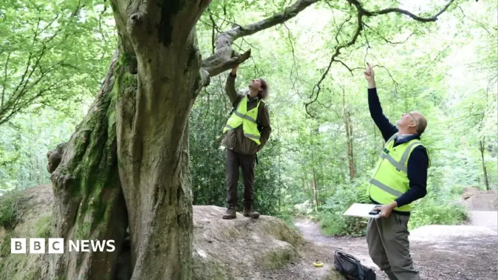
To tackle this vast expanse, project organizers deployed a decentralized community-science model. Rather than relying solely on a small team of professional arborists or ecologists, the Lost Woods initiative mobilized approximately 20 dedicated local volunteers. Each volunteer was assigned a specific one-square-kilometer grid square to survey meticulously. Armed with measuring tapes, GPS devices, identification guides, and historical maps, these citizen scientists began the painstaking task of inspecting hedgerows, private lands, public footpaths, and forgotten corners of the Sussex countryside.
The Operational Methodology
The work undertaken by the volunteers is rigorous and methodical. Identifying an ancient or veteran tree requires a keen eye for specific morphological markers. Trees are assessed based on girth, crown structure, the presence of deadwood, hollowing trunks, and specialized fungal communities. Once a candidate tree is located, volunteers record its precise location, species, dimensions, and ecological condition.
This data undergoes a rigorous verification process before being formally submitted to the Ancient Tree Inventory (ATI). Maintained by the Woodland Trust, the ATI has served as the definitive national database for the UK’s oldest and most remarkable trees for the past two decades. By feeding local discoveries from Sussex into this national archive, the Lost Woods volunteers are actively contributing to a grander, nationwide effort to map and protect the country’s living heritage.
Reaching the 5,570-Tree Milestone
As months of fieldwork progressed through the changing seasons of 2024, the cumulative data began to paint a striking picture. The distribution of recorded trees, visible when mapped digitally, clearly highlights the zones of intense volunteer activity. Clusters of data points bloom across the landscape, marking areas where dedicated individuals have combed through local woodlands and agricultural boundaries.
In late 2024, the project reached its significant numerical milestone, officially surpassing 5,500 recorded trees. Far from signaling the end of the endeavor, this milestone serves as a vital checkpoint. It demonstrates the efficacy of the community-science model while underscoring the sheer density of veteran trees surviving in the modern Sussex landscape—many of which had previously escaped official notice.
Supporting Context, Metrics, and Ecological Significance
Decoding the Botanical Classifications
To understand the true weight of the 5,570 trees recorded by the Lost Woods volunteers, it is essential to examine how arborists and ecologists classify these mature specimens. The Ancient Tree Inventory utilizes distinct categories to define trees based on their developmental stage and ecological characteristics:
- Ancient Trees (348 recorded): These are specimens that have reached the third and final stage of their biological lives. Their trunks are typically hollow, their crowns may have experienced significant retrenchment (shrinking in size to maintain balance and energy), and their bark bears the deep fissures and scars of centuries. In relative terms, an ancient tree is one that is old compared to other trees of the same species, often holding immense cultural, historical, and wildlife value.
- Veteran Trees (2,743 recorded): Representing the largest proportion of the trees documented in the Sussex survey, veteran trees are survivors. While they may not have reached the extreme old age of ancient trees, they have developed many of the same specialized micro-habitats—such as rot holes, loose bark, and deadwood. These features are usually only found on ancient trees, making veteran specimens crucial ecological bridges in the landscape.
- Notable Trees (2,467 recorded): These are mature trees that are unusually large in comparison to other trees surrounding them in the local landscape. While they may not yet exhibit the advanced decay features of veteran or ancient trees, they are the future veterans of the forest, possessing the robust growth required to sustain local ecosystems in the decades and centuries to come.
The Ecological Engine: Fungi, Invertebrates, and Biodiversity
The numerical breakdown of the Sussex survey reveals a landscape rich in transitional and mature arboreal life. According to project experts, these trees are far more than aesthetically pleasing landscape features; they are critical biological hubs.
As trees age and begin to decay internally, they create specialized micro-climates that cannot be replicated by young, fast-growing timber. The presence of decaying wood—known scientifically as saproxylic material—supports an astonishing array of specialized organisms. Fungi play a foundational role in this process, breaking down tough lignin and cellulose, softening the wood, and creating hollows that serve as nesting and roosting sites for bats, owls, and wood-boring beetles.
In the context of the Sussex project, Bob Epsom emphasized that these trees are "very important for the landscape, [and] very important for biodiversity" precisely because of the complex fungal communities they host. Many rare species of fungi, lichens, and invertebrates are entirely dependent on the continuity of ancient and veteran trees within a specific geographic range. When an ancient tree is lost without a younger veteran nearby to take its place, these localized ecological networks can collapse entirely.
Landscape Connectivity and the Broader Restoration Vision
The Lost Woods project does not view trees in isolation. The overarching philosophy of the initiative is rooted in landscape ecology—the understanding that wildlife populations and ecological processes depend on continuous, connected networks of habitat rather than isolated pockets of nature.
By mapping ancient and veteran trees across a 121-square-mile area, the project is identifying the ecological stepping stones that link fragmented woodlands. Many of these trees stand in hedgerows, historic parklands, or agricultural fields outside of formally protected nature reserves. Documenting their locations allows conservationists to advocate for sympathetic land management practices among local farmers, landowners, and local authorities, ensuring that these vital green corridors remain intact and resilient in the face of pressures such as climate change, shifting agricultural subsidies, and residential development.
Official Statements and Stakeholder Perspectives
Insights from Project Leadership
The success of the Lost Woods tree-recording phase thus far has elicited profound pride and renewed determination from the project’s leadership team. Speaking on the milestone, Bob Epsom, outreach adviser for the initiative, highlighted both the unexpected scale of the discoveries and the dedication of the community workforce driving the project forward.
"When we look at the map of it, we can see the new clusters of trees being added… that’s where the volunteers have been active," Epsom observed, pointing to the visual representation of the survey data. He candidly admitted that the total tally of 5,570 trees went far beyond initial projections: "It’s more than we expected, and it signifies a major milestone for the project."
However, Epsom was quick to contextualize the achievement within the broader arc of environmental stewardship. He stressed that mapping trees is merely the initial phase of a much larger, generational commitment to nature recovery.
"The mapping process is only the first step. We need to make sure that trees are recognised, cared for and protected so that they can continue to support wildlife and communities for generations to come."
— Bob Epsom, Outreach Adviser, Lost Woods Project
This sentiment underscores the philosophical shift occurring within modern conservation: documentation must be seamlessly coupled with active protection and community engagement if ecological restoration is to succeed in the long term.
The Collaborative Framework
The success of the Lost Woods initiative highlights the power of cross-sector collaboration. By pooling the resources, administrative reach, and specialized knowledge of four distinct charities—the Woodland Trust, Action in Rural Sussex, the Sussex Wildlife Trust, and the Small Woods Association—the project has achieved an operational efficiency that no single organization could have managed alone.
- The Woodland Trust provides the national standard for tree recording, feeding local Sussex data directly into the Ancient Tree Inventory, thereby connecting regional grassroots efforts with national conservation policy.
- Action in Rural Sussex anchors the project within local communities, ensuring that rural residents, landowners, and parish councils are actively involved in and supportive of conservation goals.
- The Sussex Wildlife Trust infuses the initiative with rigorous ecological oversight, ensuring that tree recording aligns with broader biodiversity strategies across the county.
- The Small Woods Association champions the sustainable management of woodlands, bridging the gap between historical land use practices and modern conservation economics.
Support from the National Lottery Heritage Fund has been instrumental in providing the financial stability required to sustain this multi-year effort, proving that public investment in natural heritage yields tangible dividends for community well-being and ecological resilience.
Future Outlook and the Road Ahead
Completing the Survey: The 2025 Horizon
Despite the jubilation surrounding the 5,500-tree milestone, project organizers are acutely aware that significant work remains. The primary operational objective for the volunteer network is to locate and record every single ancient and veteran tree within the 121-square-mile project area by next year.
Bob Epsom noted that the team still "have a reasonable amount to cover." As volunteers push into new grid squares, navigating private boundaries, dense undergrowth, and remote rural terrain, the logistical challenges will undoubtedly evolve. Yet, the momentum generated by the recent milestones provides a strong psychological and practical boost to the field teams. The proven effectiveness of the one-square-kilometer surveying model gives organizers confidence that the final targets will be met on schedule.
Moving from Inventory to Active Stewardship
Once the comprehensive inventory of the Lost Woods project area is finalized, the initiative will transition into its next crucial phase: active stewardship and landscape-scale restoration.
Cataloguing a tree provides it with an official identity and a place in the national archive, but it does not automatically guarantee its physical survival. The next phase of the Lost Woods program will focus heavily on engaging landowners, farmers, and local authorities to implement sympathetic management plans. This may include:
- Halothane and Buffer Creation: Establishing protective buffer zones around ancient trees to prevent agricultural runoff, soil compaction from heavy machinery, and root damage.
- Haloporting and Crown Care: Utilizing arboricultural best practices to manage the weight loads of ancient limbs, preventing catastrophic structural failure while preserving vital wildlife habitats.
- Regeneration and Planting: Encouraging natural regeneration around veteran specimens and planting the next generation of potential veteran trees to ensure ecological continuity for centuries to come.
Community Engagement and the Legacy of the Lost Woods
Crucially, the Lost Woods project is designed to leave a lasting legacy within the human communities of Sussex as well as its natural ecosystems. By engaging local volunteers in the rigorous process of scientific fieldwork, the project has fostered a deep sense of place, ownership, and environmental literacy among residents.
Participants who once walked past anonymous old oaks in a Sussex field now understand the complex ecological webs sustained within those gnarled trunks. This grassroots empowerment is perhaps the most enduring achievement of the initiative. As these volunteers share their knowledge with neighbors, schools, and local councils, they help build a cultural climate in which ancient trees are viewed not as inconvenient obstacles to modern development, but as irreplaceable cultural monuments and vital ecological lifelines.
As the Lost Woods project marches toward its completion target next year, the initiative stands as a shining example of what can be achieved when national funding, institutional expertise, and passionate local volunteers unite in defense of our shared natural heritage. In the ancient woodlands of Sussex, the past and the future are meeting—and through careful stewardship, those ancient roots are securing a greener, more resilient tomorrow.



