

By Ben Rich (Lead Weather Presenter) & Mark Poynting (Climate Journalist)
Executive Overview
Meteorological authorities across the globe have sounded an urgent alarm regarding a developing El Niño event over the Pacific Ocean that is tracking to become the most powerful climate phenomenon of its kind in living memory. Amplified by the relentless background trajectory of human-induced global warming, this exceptionally intense natural cycle is projected to drive worldwide temperatures to unprecedented heights, making it "very likely" that 2027 will shatter all historical records to become the hottest calendar year in human history.
With deep-ocean heat reservoirs recording temperatures up to 8°C above normal and surface measurements already outstripping traditional thresholds, scientists warn that we are entering uncharted meteorological territory. The compounding effects of this colossal El Niño event are already altering regional weather systems—triggering depressed monsoon rainfall across South Asia, suppressing Atlantic hurricane activity, and threatening tens of millions of vulnerable populations with severe food insecurity. As global average temperatures hover approximately 1.4°C above pre-industrial levels, the unfolding crisis highlights the dangerous intersection of cyclical ocean phenomena and long-term anthropogenic climate change.
What is El Niño? The Mechanics of a Global Disruptor
To understand the scale of the impending meteorological anomaly, one must examine the foundational mechanics of the El Niño-Southern Oscillation (ENSO) cycle. El Niño is a naturally occurring, periodic climate pattern that typically emerges every two to seven years, persisting for approximately twelve months.
Under normal conditions, trade winds blow predominantly from east to west across the tropical Pacific Ocean, pushing warm surface waters toward Asia and Australia while drawing up cooler, nutrient-rich deep water—a process known as upwelling—off the coast of South America. However, during an El Niño phase, these trade winds weaken significantly or, in extreme cases, reverse direction entirely. This atmospheric shift allows massive pools of warm water to surge eastward across the Pacific basin.
[Normal Conditions]                [El Niño Conditions]
Easterly Trade Winds               Weakened/Reversed Winds
  ████████████>                      <████████████
(Warm water piled west)            (Warm water spreads east)
  [Asia/Australia]                   [South/Central America]
As this vast volume of warm water migrates, it releases colossal amounts of thermal energy from the ocean straight into the atmosphere. This sudden and profound transfer of heat alters global atmospheric circulation, shifting jet streams and drastically modifying regional rainfall patterns across the planet.
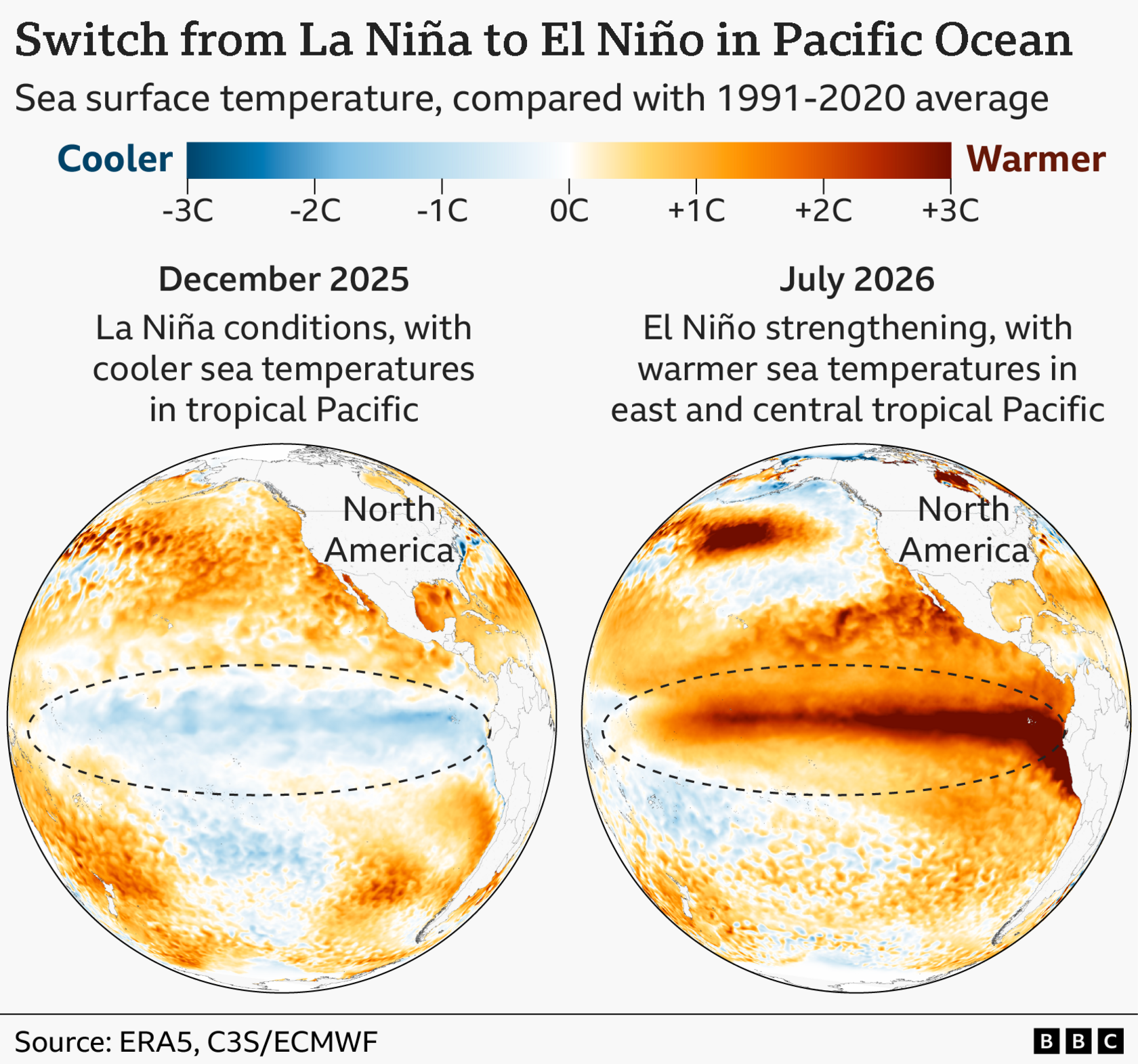
Scientists traditionally declare the onset of an El Niño event when sea surface temperatures in a critical sector of the central and eastern tropical Pacific rise 0.5°C or more above the long-term historical average. However, the current event has obliterated baseline expectations. Contemporary measurements indicate that surface temperatures in these key regions are already soaring well over 2°C above normal. Latest long-range forecasting models from the UK Met Office suggest that this thermal anomaly could accelerate, exceeding a staggering 3°C above average later this year as the event reaches its formidable peak.
Detailed Chronology and Meteorological Evidence
The velocity and intensity with which the current El Niño has materialized have caught even seasoned climatologists off guard.
- Late 2025: Tropical Pacific conditions were characterized by cooler-than-usual sea surface temperatures, a classic indicator of La Niña—the cooling counterpart to El Niño. Transition phases typically allow for a gradual equilibration of ocean-atmosphere dynamics.
- Early to Mid-2026: Predictive models began picking up an unusually rapid phase shift. Sub-surface ocean anomalies revealed immense pockets of thermal energy, with water temperatures sitting roughly 8°C above normal at a depth of 100 meters (330 feet) in localized zones of the Pacific. These subterranean reserves have acted as a thermal supercharger, providing a continuous reservoir of warm water to fuel surface warming.
- Mid-2026 (Current Status): Sea surface temperatures have breached the 2°C anomaly threshold. Meteorological agencies worldwide are observing structural shifts in global wind patterns and atmospheric pressure systems that consistently align with the onset of a historic El Niño.
"We should be clear that this is an unprecedented event," stated Prof. Adam Scaife, head of long-range forecasting at the UK Met Office. "I have never seen an El Niño signal this intense in our forecasts."
Independent research groups echo these grave assessments. Dr. Zeke Hausfather, a climate scientist at the US-based research organization Berkeley Earth, noted that certain advanced multi-model projections hint at peak anomalies climbing as high as 4°C above average.
"If that came to pass, it’s not beyond the realm of possibility to say this might be the strongest El Niño event in 500 or even 1,000 years," Hausfather cautioned, while acknowledging the inherent uncertainties in reconstructing historical paleo-climatological baselines over millennium-long scales. "We have many months to go while this event continues to develop, and that’s one of the reasons that we have increased confidence that this will be a record-setting event."
Supporting Context, Metrics, and Scientific Debate
The relationship between cyclical phenomena like El Niño and long-term anthropogenic climate change remains a subject of intensive scientific inquiry and debate.
According to the World Meteorological Organization (WMO), direct empirical evidence currently shows no clear indication that human-induced climate change is increasing the intrinsic frequency or strength of El Niño events. Historical proxy data—spanning tree rings, coral skeletons, and ice cores—reveals that El Niño events have historically fluctuated wildly in magnitude and occurrence over past millennia.
However, a landmark 2021 report from the Intergovernmental Panel on Climate Change (IPCC) noted that the statistical intensity of El Niño episodes appears to have trended upward since 1950 when compared to baselines dating back to approximately 1400 AD.
Regardless of whether climate change is actively amplifying the engine of El Niño itself, scientists agree on a critical reality: El Niño is now unfolding against the backdrop of an already-warming world. Global average temperatures have escalated by roughly 1.4°C since the late 19th century, primarily driven by the combustion of fossil fuels and industrial emissions. Consequently, the regional weather extremes triggered by El Niño are superimposed upon a hotter baseline climate, compounding risks and magnifying environmental impacts.
Global Economic and Agricultural Vulnerabilities
The macroeconomic and humanitarian fallout of a severe El Niño is profound. Past episodes have routinely inflicted hundreds of billions of dollars in global GDP losses, driven by cascading failures in agricultural supply chains, critical infrastructure damage, and international trade disruptions.
- Crop Yield Collapses: Major commodities including coffee, rice, cocoa, and palm oil are highly sensitive to the shifts in precipitation and temperature brought on by El Niño. Historical events have triggered steep production declines, directly correlating with global spikes in food prices.
- Acute Food Insecurity: Earlier this month, the United Nations Food and Agriculture Organization (FAO) issued a stark warning. The organization cautioned that the unfolding El Niño could push tens of millions of people residing in structurally vulnerable developing nations into crisis-level acute food insecurity.
Official Statements and Global Impacts
The macro-scale impacts of the developing El Niño are already manifesting across multiple continents, demonstrating the vast teleconnections that link Pacific Ocean dynamics to remote weather systems.
1. South Asia and Monsoons
In years dominated by an El Niño, the southwest monsoon typically suffers from suppressed rainfall across the Indian subcontinent. Observational data for 2026 confirms that seasonal monsoon rains are running significantly below historical averages, raising immediate concerns for agricultural output and water resource management in the region.
2. The Americas and Australasia
- Drought and Wildfires: Regions in close proximity to the western tropical Pacific, including northern parts of South America and large swathes of Australia, face sharply elevated risks of severe drought and catastrophic wildfires.
- Flooding: Conversely, nations along the western coast of South America—such as Peru and Ecuador—along with the southern United States, face an increased probability of torrential rainfall, riverine flooding, and severe storm surges.
3. The Atlantic Basin and Europe
- Suppressed Hurricanes: Interestingly, El Niño can induce opposing effects in specific maritime zones. Changes in upper-level wind shear across the Caribbean and the tropical Atlantic frequently suppress tropical cyclone development. So far this season, this mechanism has kept Atlantic hurricane activity subdued, with only three named storms recorded to date.
- The UK and North-West Europe: While El Niño’s direct influence on the UK’s summer heatwaves has been minimal, its footprint is expected to expand markedly during the autumn and early winter. Long-range forecasts indicate a heightened risk of wet, stormy weather systems sweeping across north-west Europe. Counter-intuitively, historical data suggests El Niño can also correlate with increased odds of cold snaps late in the winter season, though the causal mechanisms linking the tropical Pacific to European winter extremes remain loosely defined.
Future Outlook: 2027 and Beyond
The ultimate legacy of this monumental El Niño event will likely be written in global temperature records over the next 24 to 36 months.
According to Dr. Nick Dunstone, a climate scientist at the UK Met Office, the atmospheric temperature boost delivered by an El Niño event does not peak concurrently with the ocean anomaly. Instead, the maximum thermal feedback loop typically manifests during the calendar year following the winter peak of the phenomenon.
"Hence, 2027 is very likely to replace 2024 as the warmest year on record," Dr. Dunstone stated definitively.
As international meteorological agencies continue to monitor the trajectory of the Pacific basin, governments, agricultural cartels, and disaster management organizations are urged to fortify emergency preparedness protocols. The convergence of an unprecedented El Niño with an accelerating global climate trajectory serves as an urgent reminder of the fragility of modern socio-economic systems in the face of planetary-scale environmental shifts.



