

Executive Overview
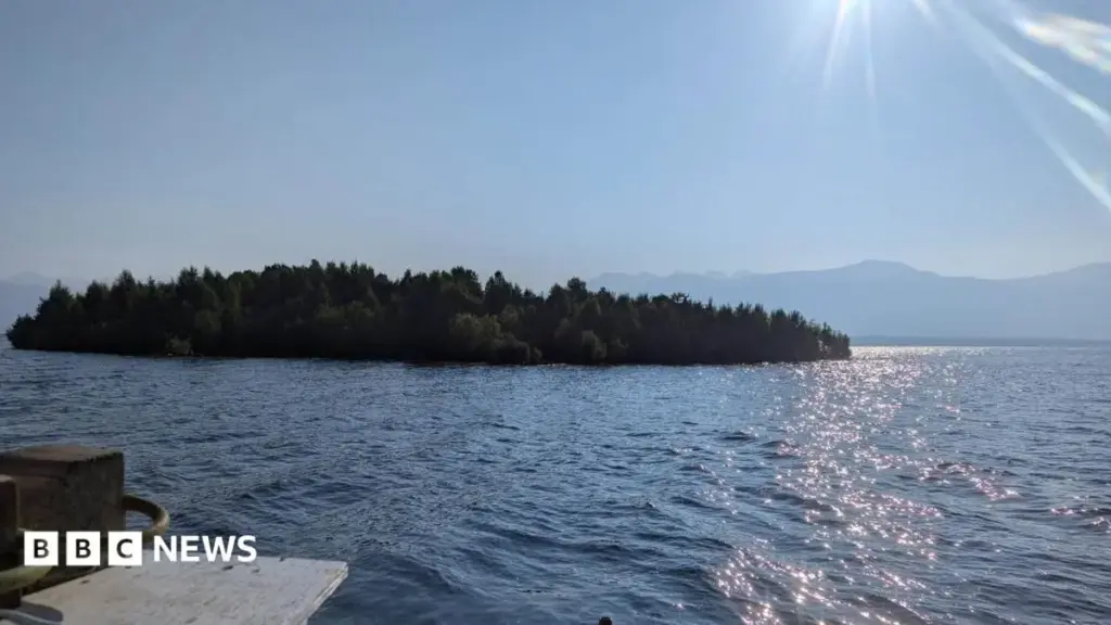
In the remote wilderness of northern British Columbia, an environmental anomaly recently captured the global imagination, baffling local residents, environmental authorities, and internet sleuths alike. A densely forested mass of land—spanning approximately the size of one-and-a-half American football fields—was discovered bobbing unmoored in the middle of the Williston Reservoir, the province’s largest freshwater body. What followed was a brief, high-stakes geographic mystery: after its initial viral discovery by local boaters and subsequent confirmation by satellite imagery, the massive island inexplicably vanished from its recorded coordinates, triggering international media fascination and speculation regarding its fate.
Weeks later, provincial utility officials announced that the elusive landmass had been relocated. Having drifted nearly 30 kilometers (18.6 miles) from its original sighting, the island has safely settled near the reservoir’s rugged shoreline. Confirmed by updated satellite data and aerial reconnaissance, the reappearance puts to rest a flurry of theories that ranged from the whimsical to the catastrophic.
Yet, beyond the viral novelty of a wandering forest lies a fascinating convergence of hydrology, climatology, and natural history. The formation of such a massive floating structure—estimated at roughly one hectare (9,800 square meters)—sheds light on the complex dynamics of managed waterways and the unique ecological processes that produce self-sustaining, mobile ecosystems. While authorities have confirmed the island is grounded for now, officials warn that the structure remains inherently unstable, serving as a powerful reminder of nature’s unpredictable volatility in remote environments. This report provides an in-depth examination of the chronological events, the scientific mechanics behind the phenomenon, comparative global examples, and the official safety directives governing British Columbia’s most famous drifting landmass.
Detailed Chronology: From Viral Sensation to Satellite Ghost Hunt
The saga of the Williston Reservoir floating island unfolded in a series of surreal developments over the course of the late Canadian summer, moving rapidly from regional curiosity to global news.
Early August: The Boaters’ Discovery
The phenomenon first entered the public consciousness during the first week of August. A group of local boaters navigating the sprawling waters of the Williston Reservoir—situated in a rugged, sparsely populated region of northern British Columbia—stumbled upon a sight that defied conventional expectations. Floating entirely detached in deep water was a substantial patch of mature, living forest.
Capturing the surreal moment on video, the boaters documented the trees visibly swaying and bobbing with the movement of the water. The footage quickly made its way onto Canadian social media platforms, where its visceral oddity immediately caught traction. To the casual observer scrolling through their feeds, the footage looked less like reality and more like the product of advanced computer-generated imagery (CGI) or a glitch in spatial software.
Mid-August: Verification and the Vanishing Act
Among those who initially dismissed the video as a digital hoax was Bob Gammer, a communications spokesperson for BC Hydro, the provincially owned utility responsible for maintaining the Williston Reservoir and the nearby W.A.C. Bennett Dam.
"I thought, well, this could be anywhere," Gammer recounted to the BBC. "Maybe it’s not real."
Driven by professional due diligence rather than immediate alarm, Gammer’s team decided to investigate further. They pulled archival satellite data to cross-reference the video’s claims. To their astonishment, a high-resolution satellite image captured on July 21 definitively confirmed the island’s existence. The imagery showed the massive, leafy mass floating securely in the pelagic expanse of the reservoir’s northern reaches.
However, the scientific validation was short-lived. When BC Hydro officials pulled a subsequent satellite image captured just a few weeks later on August 5, the island was gone. The coordinates that had previously housed the sprawling green patch now showed only open, unbroken water.
The Global Mystery
The sudden disappearance of an island-sized expanse of forest transformed the incident from a quirky local sighting into an international news story. Outlets across the globe picked up the narrative, generating widespread intrigue. Speculation ran rampant across digital forums. Had the island broken apart under water currents and plunged to the depths of the reservoir? Had it drifted unnoticed into a distant, shadowed fjord of the massive man-made lake?
"We just don’t know where it went," Gammer admitted at the height of the mystery. "Did it sink? Did it find its way into another corner of the reservoir?"
Late August: The Reappearance
The mystery was ultimately resolved through a combination of modern orbital technology and old-fashioned eyewitness reporting. Approximately two weeks after its disappearance, new satellite telemetry—bolstered by eyewitness confirmations from bush pilots flying commercial routes over the remote region—spotted the missing landmass.
The island had not vanished into the abyssal depths of the reservoir; rather, it had maintained a slow, unguided drift across the water, eventually making landfall along the shore roughly 30 kilometers (18.6 miles) away from its July position. With its physical location re-established, the high-profile search came to an official close, leaving scientists and engineers to analyze how such a massive geological feature could break free and travel across a massive body of water.
Supporting Context & Metrics: Anatomy of an Accidental Voyager
Understanding the Williston Reservoir floating island requires a close examination of the geographical, hydrological, and physical metrics that define the region.
Scale and Dimensions
To comprehend the sheer magnitude of the floating landmass, BC Hydro’s engineering and surveying teams calculated its surface area:
- Total Surface Area: Approximately 9,800 square meters, translating to roughly 1 hectare.
- Comparative Scale: Equivalent to roughly 1 Canadian football field or 1.5 American football fields.
- Composition: A dense amalgamation of organic debris, root systems, soil matrices, and mature standing trees.
Hydroelectric Infrastructure and Water Levels
The Williston Reservoir is not a natural body of water in the traditional sense. Formed in 1968 following the construction of the W.A.C. Bennett Dam on the Peace River, the reservoir is British Columbia’s largest body of fresh water, flooding a vast basin that encompasses several major river valleys, including the Finlay, Parsnip, and Peace reaches.
According to BC Hydro, the catalyst for the island’s grand departure was a dramatic fluctuation in water levels. During the summer months, the reservoir experienced exceptionally high water marks—levels that had not been recorded since 2012. As rising waters inundated the shallow perimeter zones, the hydrostatic pressure and shifting buoyancy lifted massive accumulations of shoreline organic matter, eventually tearing them away from the mainland substrate and setting them adrift on the open water.
Scientific Genesis: How Floating Islands Form
While visually startling, floating islands—scientifically referred to as tussocks, quaking bogs, or floating mats—are a well-documented ecological phenomenon in various wetland and lacustrine environments across the globe.
In the case of the Williston Reservoir, the prevailing hypothesis points to a multi-year accumulation of organic debris. Over decades, driftwood, logs, and forest detritus washed down from surrounding river systems accumulated in calm coves and shallow shorelines. As this dense mat of woody debris intertwined, it collected wind-blown sediment, organic humus, and decaying plant matter. Over time, resilient local flora—including shrubs, grasses, and even substantial trees—took root in the nutrient-rich matrix, using the interlocking web of logs and roots as a floating foundation. When water levels rose to historic highs this summer, the buoyant root systems and timber framework decoupled from the lakebed, transforming a static section of shoreline into an autonomous, mobile vessel.
Comparative Global Perspectives: The Phenomenon Worldwide
While an island the size of a football field suddenly navigating a Canadian reservoir is exceptionally rare, the broader phenomenon of floating islands occurs in various distinct ecosystems around the world. Examining these analogs provides valuable context for understanding the behavior and ecological longevity of the Williston discovery.
The Forty Acre Bog of Wisconsin
Perhaps the most famous comparative case exists in the United States, specifically within the Chippewa Flowage in northern Wisconsin. Known locally as the "Forty Acre Bog," this massive floating mat of peat and vegetation moves dynamically across the water depending on wind currents and water levels.
Much like the Williston island, the Wisconsin bog behaves with deceptive solidity. Local residents often describe it as an ecological iceberg. Cheryl Treland, a local resident interviewed by Wisconsin Public Radio, highlighted the physical reality of these structures:
"This isn’t like a leaf floating on the top of the water."
The Forty Acre Bog is so substantial that local boaters and resort associations occasionally have to actively intervene during particularly windy seasons, physically pushing the floating mass to prevent it from colliding with local bridges and infrastructure. Ecologically, however, these floating entities act as vital, mobile sanctuaries. They support rich micro-ecosystems, providing undisturbed habitats for amphibians such as frogs and salamanders, as well as specialized flora adapted to dynamic aquatic interfaces.
Legal and Ecological Status
In regions where floating islands are more common, such as the upper Midwest of the United States, these formations are frequently granted strict environmental protections. Because they harbor diverse wildlife and contribute to the overall health of the watershed’s water quality, they are often legally integrated into state conservation laws, mirroring the protections afforded to traditional shorelines.
However, the Williston Reservoir island differs significantly in its structural integrity. While Wisconsin’s bogs are often bound together by thick mats of spongy peat, the Canadian island is primarily rooted in dense accumulations of deadfall, timber, and unstable soil matrices, making its structural cohesion far more precarious.
Official Statements and Risk Assessment
As news of the island’s reappearance spread, public curiosity naturally shifted from scientific fascination to recreational ambition. In an era defined by social media trends and experiential tourism, the prospect of visiting, photographing, or even stepping foot onto a wandering forest proved tempting to some adventurous travelers.
BC Hydro has issued a swift, unequivocal warning to temper any such impulses.
The Danger of Instability
Bob Gammer emphasized that despite appearances, the island is not a stable geographical feature capable of supporting human weight or foot traffic.
"It is remote, and most people will never come near it," Gammer noted during interviews addressing public safety. However, for those possessing the nautical means and the adventurous drive to seek it out in the vast expanses of northern British Columbia, his warning was explicit:
"Stay off the island. It could break apart."
Engineering and Environmental Safety
From an infrastructure perspective, BC Hydro continues to monitor the movement of the landmass, though it currently poses no immediate threat to the W.A.C. Bennett Dam or surrounding navigational pathways. Because the island has drifted into a relatively sheltered near-shore environment—anchored roughly 30 kilometers away from its initial viral waypoint—its immediate trajectory appears to have stabilized.
Nevertheless, environmental officers point out that dynamic weather systems, high winds, and future shifts in reservoir water management could theoretically dislodge the island once more, sending it on another unpredictable journey across the water.
Future Outlook: Monitoring Nature’s Wanderers
The saga of the Williston Reservoir floating island offers a compelling lens through which to view the intersection of managed human infrastructure and untamed natural processes. What began as a bewildering video captured on a smartphone has evolved into a fascinating case study in hydro-geomorphology, demonstrating how massive environmental systems can reorganize themselves in response to changing climatic and hydrological conditions.
As water management strategies adapt to increasingly volatile weather patterns—marked by extreme precipitation events and fluctuating reservoir levels—phenomena like floating forests may become more frequently documented. Whether the Williston island remains permanently grounded against its new shoreline or eventually breaks apart during future seasonal thaws remains to be seen.
For now, the wandering forest rests quietly in the northern reaches of British Columbia, serving as a powerful testament to the wild, resilient, and often surprising nature of the Canadian wilderness. BC Hydro and local authorities will continue to monitor the site remotely via satellite imagery and aerial patrols, ensuring that both public safety is maintained and this remarkable natural anomaly is allowed to follow its course undisturbed.



