

Executive Overview
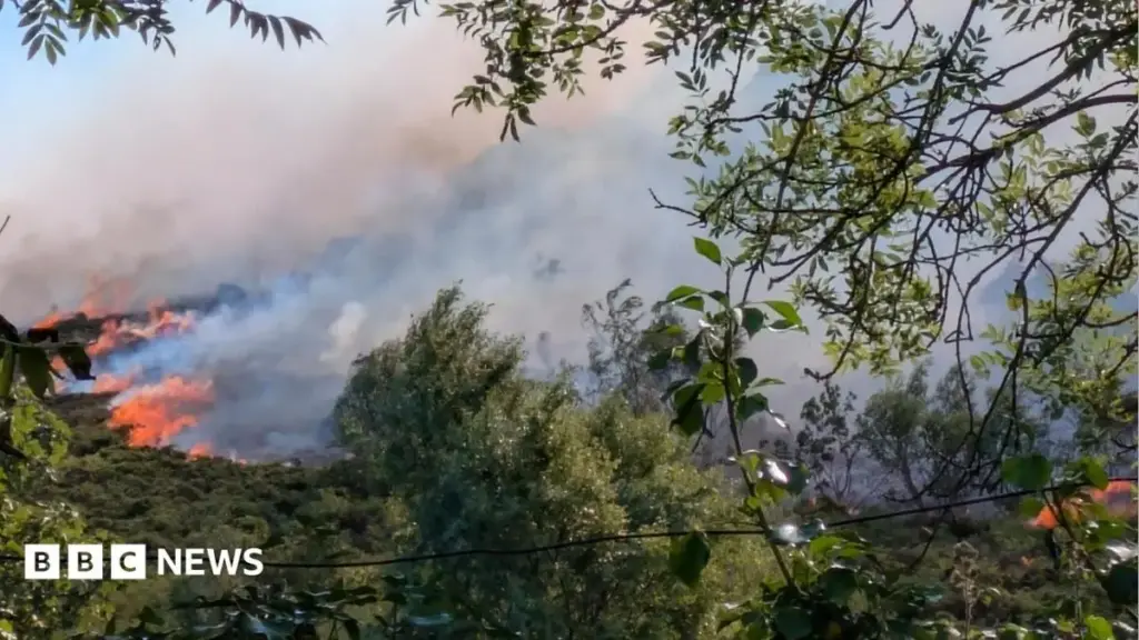
The blistering summer of recent years brought more than just unprecedented atmospheric heat to the United Kingdom; it triggered an ecological reckoning across the Welsh countryside. While news headlines during July and August were dominated by the harrowing visual spectacles of towering flames, billowing smoke, and emergency evacuations, scientists working behind the front lines warn that the true disaster remains largely hidden from public view.
According to leading researchers from Bangor University, the physical devastation witnessed above ground—the blackened expanses of heather, charred gorse, and scorched bracken—is merely the symptom of a much deeper, more insidious crisis. The real story, they assert, is unfolding silently beneath our feet.
Extreme heat and exceptionally prolonged dry spells transformed vital Welsh habitats—including delicate heathlands, carbon-rich moorlands, and expansive upland grasslands—into a tinderbox. This vulnerability fueled one of the most destructive wildfire seasons in recent British history. In north Wales alone, approximately 2,760 acres of countryside were scorched during the July peak, a staggering expanse equivalent to more than 1,500 standard football pitches.
Yet, the loss of vegetation, severe as it is, pales in comparison to the obliteration of the underlying pedosphere. At critical sites such as the Sychnant Pass in Conwy county, researchers have recorded the complete vaporization of up to 10 centimeters of vital topsoil. In ecological terms, this translates to the irreversible destruction of organic layers that took upwards of 4,000 years to accumulate.
This comprehensive investigative report examines the multi-layered impacts of this summer’s infernos. By synthesizing firsthand accounts from soil scientists, cutting-edge satellite data metrics, and long-term climate projections, we explore how the loss of ancient soils is accelerating a dangerous feedback loop of global climate change, threatening specialized biodiversity hotspots, and challenging the very future of the Welsh landscape.
Detailed Chronology of a Crisis: From Dry Conditions to Emergency Evacuations
The trajectory of this ecological disaster was forged months before the first spark ignited. Unprecedented meteorological conditions throughout the spring and early summer created a powder-keg environment across the British Isles. Extended periods of high atmospheric pressure, record-breaking temperatures, and near-absence of meaningful rainfall reduced the moisture content of Wales’s upland vegetation to critically low levels.
By July, the landscape had shifted from a lush, resilient carbon sink into an extremely volatile fuel source. The crisis reached a dramatic crescendo mid-summer, when fast-moving blazes erupted across multiple remote and semi-rural locations in north Wales.
The human and infrastructural toll of these events was immediate. One of the most acute emergencies unfolded at the historic Sychnant Pass within Conwy county. As erratic winds drove walls of flame rapidly toward residential perimeters, local emergency services were forced into swift action. Approximately 36 homes were evacuated under harrowing conditions as towering columns of smoke choked the valleys.
In total, the Sychnant Pass blaze consumed roughly 200 acres of internationally significant conservation land. While fire crews worked tirelessly to protect human life and property, the sheer velocity and intensity of the fires meant they outpaced traditional containment strategies.
As the flames finally subsided, leaving behind a sterile landscape of ash and soot, a new race against time began. Recognizing that approaching autumn and winter storms could obliterate remaining evidence, a specialized team of researchers from Bangor University mobilized immediately. Racing against the clock—and impending heavy rainfall—scientists deployed to the scorched sites to capture critical baseline data before the elements could wash away the physical record of the disaster.
Supporting Context & Metrics: The Science Beneath Our Feet
To comprehend the magnitude of the disaster, one must look closely at the complex mechanics of upland soils. Led by Prof. Davey Jones, the Bangor University survey team has spent recent weeks analyzing multiple burn sites across Wales, deploying a combination of ground-level sampling and advanced remote-sensing technology, including NASA satellite data, to map and evaluate the damage.
The Anatomy of an Upland Soil Collapse
"People see the blackened vegetation and assume that’s the main impact, but the real story is below our feet," Prof. Jones explains.
In healthy ecosystems, topsoil serves multiple critical functions simultaneously:
- The Carbon Store: Upland soils, particularly peat and organic-rich heathland soils, lock away vast quantities of carbon sequestered over millennia. At Sychnant Pass, the loss of 10 centimeters of topsoil meant that roughly 4,000 years of stored carbon was released or destroyed in a matter of days.
- The Water Sponge: A deep, organic-rich soil matrix acts as a natural hydrological regulator, absorbing heavy rainfall and slowly releasing it, thereby mitigating downstream flooding. The destruction of this sponge transforms the landscape into an impervious surface prone to flash flooding.
- The Nutrient Bank: Essential microbial communities, nitrogen, phosphorus, and sulfur are housed within the topsoil layers. When these are incinerated, the biological engine that drives plant regeneration is shattered.
Furthermore, the physical structure of the soil undergoes a chemical transformation during severe fires. High temperatures can induce severe water repellency (hydrophobicity) in the remaining soil layer, preventing future rainfall from infiltrating the ground and instead causing it to run off rapidly, carrying away what little topsoil remains.
The Illusion of Green Recovery
Visitors to burn sites often experience a false sense of security upon observing early signs of life returning to the landscape. At Sychnant Pass, faint green shoots have already broken through the charred crust. However, Dr. Kara Marsden, a lecturer in soil science involved in the project, cautions that these superficial signs do not indicate genuine ecological recovery.
"It was really important that we got on site very quickly to measure the soil and vegetation properties while the fire’s impacts were still fresh," Dr. Marsden notes. "These things can change rapidly, so capturing that baseline data now means we’ll have something accurate to compare against in future sampling dates."
Explaining the deceptive nature of the early regrowth, she points to the distinct survival mechanisms of different plant species:
- Bracken Resilience: Bracken sprouts almost immediately following a fire because its deep-seated rhizomes sit far down in the soil profile, largely protected from the immediate heat of the surface burn layer.
- Heathland Vulnerability: In stark contrast, specialized dwarf shrubs such as heather (Calluna vulgaris) and gorse rely on much shallower root systems. The intense heat completely incinerates these roots, meaning foundational species are entirely eradicated—along with the specific soil depth they depend upon, which could take millennia to regenerate.
Official Statements and Expert Analysis
The implications of the Welsh wildfires extend far beyond local botanical loss, intersecting directly with international climate policy and ecological resilience frameworks.
"We’ve probably lost about 10 centimetres of soil here [at Sychnant Pass] so we’ve lost all of that organic matter layer… 4,000 years of carbon gone in a single event. Once the topsoil is gone, we can never recover that." — Prof. Davey Jones, Bangor University
Prof. Jones emphasizes that the loss represents a "double whammy" for the environment: it simultaneously exacerbates global climate change through the massive emission of greenhouse gases while drastically weakening the habitat’s structural integrity against future climatic shocks.
The cascading chemical consequences are equally alarming. As organic matter burns, elements such as carbon, nitrogen, and sulfur are volatilized and discharged directly into the atmosphere.
"Every time we have a wildfire, we’re just making the problem worse and worse. It becomes a self-sustaining cycle: drier soils, more fires, more carbon released." — Prof. Davey Jones
This feedback loop threatens to permanently alter the British countryside. Without proactive intervention, scientists warn that unique habitats where the UK serves as a global epicentre for specialist plants, rare butterflies, and vulnerable insects could vanish entirely within a single human lifetime.
Future Outlook: Mitigation, Artificial Soils, and Long-Term Resilience
As the immediate emergency fades and the research team transitions from rapid-response sampling to long-term monitoring, the focus shifts decisively toward mitigation, restoration, and future preparedness.
The Challenge of Artificial Soil Generation
Given that natural topsoil accumulation is an impossibly slow geological process—measured in centimeters per millennium—scientists are beginning to think radically about how to heal permanently scarred landscapes.
Prof. Jones highlights an unprecedented technological and ecological frontier: the potential creation of engineered or artificial soils.
"If we are going to try and put that soil back, generate artificial soils through the reuse of organic wastes for example, then it’s important we understand what the soil quality is now," he explains. "So that we can prepare for the future and design those soils, because they don’t exist yet."
Such innovative remediation strategies would involve blending recycled organic materials, biochar, and specialized microbial inoculants to mimic the complex physical and biological properties of ancient topsoils, thereby providing an artificial foundation upon which lost heather and gorse communities might eventually be re-established.
A Multi-Year Monitoring Framework
Over the next two years, the Bangor University research team plans to return to the affected sites across Wales at regular intervals. Their longitudinal study will track:
- Vegetation Succession: Documenting whether native species can outcompete aggressive colonizers like bracken in damaged soil matrices.
- Microbial Recovery: Measuring the return of vital soil bacteria and fungi necessary for nutrient cycling.
- Erosion and Hydrology: Assessing runoff coefficients and soil loss metrics during increasingly erratic winter storm seasons.
Early evidence suggests that while some vegetation will inevitably return, the resulting ecosystems will be significantly altered: growing more slowly, exhibiting heightened fragility, and leaving the wider Welsh countryside increasingly susceptible to the next inevitable wave of extreme weather.
Ultimately, the 2025 wildfire season must serve as a watershed moment for environmental policy in the United Kingdom. Protecting Wales’s upland treasures will require a fundamental paradigm shift—moving away from reactive firefighting toward proactive landscape management, aggressive carbon reduction, and heavy investment in soil science before the ground beneath our feet is lost forever.



