

By Ben Rich, Lead Weather Presenter
The Gulf of Mexico is once again serving as a cauldron for severe meteorological activity as Tropical Storm Isaias rapidly organizes off the coast. Forecasters project that Isaias will strengthen into the first Atlantic hurricane of the 2026 season late Wednesday or early Thursday, potentially escalating into a formidable Category 2 storm before making landfall along the United States Gulf Coast by the end of the week.
This looming weather crisis marks a dramatic pivot for an Atlantic hurricane season that has, up to this point, defied historical norms by remaining eerily quiet. Driven largely by the persistent atmospheric disruptions of a historic, strengthening El Niño in the Pacific Ocean, the 2026 season previously set records for the latest date reached without a single hurricane formation since the dawn of the satellite era in the 1960s.
However, localized oceanic heat anomalies in the Gulf of Mexico—where sea surface temperatures are currently hovering between 30°C and 31°C (about 2°C above normal)—have provided the ideal thermodynamic fuel to break this extended atmospheric drought. As Isaias tracks northward and eastward, it threatens to unleash a triple-threat hazard of damaging winds, torrential rainfall, and life-threatening storm surges across the southern United States. In anticipation of the impacts, state officials have already mobilized, with Florida Governor Ron DeSantis declaring a state of emergency across 25 northern counties.
Detailed Chronology: From Gulf Genesis to Impending Landfall
The development of Tropical Storm Isaias follows a classic path of rapid tropical cyclogenesis within the warm, shallow waters of the Gulf of Mexico. Satellite imagery captured by the Cooperative Institute for Research in the Atmosphere (CIRA) and the National Oceanic and Atmospheric Administration (NOAA) over the past 48 hours illustrates a dramatic clumping of thunderstorms over the region.
Initial Formation and Early Impacts (Monday – Tuesday)
Initially organizing as an unranked tropical disturbance, the system began drawing deep moisture and thermal energy from the exceptionally warm waters near the Bay of Campeche and the Yucatan Peninsula. As the system slowly consolidated, it began throwing outer bands of moisture ashore, bringing heavy downpours—with totals anticipated to reach up to 4 inches (100 mm)—and gusty squalls to parts of coastal Mexico.

Intensification Window (Wednesday – Thursday)
According to the latest advisory updates from the US National Hurricane Center (NHC), Isaias is undergoing a period of favorable environmental conditions characterized by minimal vertical wind shear. This lack of atmospheric turbulence allows the storm’s convective core to stack vertically, facilitating a transition from a disorganized cluster of showers into a symmetric, rotating tropical cyclone. Forecasters expect Isaias to officially cross the threshold into hurricane status late Wednesday night, continuing an upward trajectory that could see it peak as a Category 2 storm by Friday morning.
Projected Landfall (Friday – Saturday)
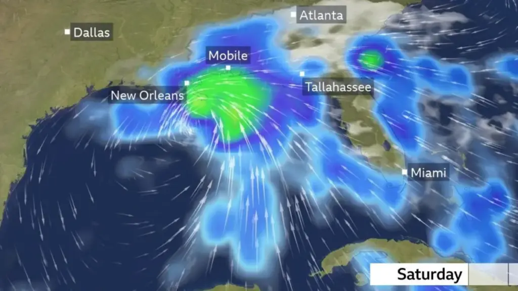
Current meteorological models track the center of Isaias toward a landfall window late Friday or early Saturday. The target zone spans the central and eastern Gulf Coast, with the current cone of uncertainty placing states such as Mississippi, Alabama, and the Florida Panhandle directly in the crosshairs. As the storm approaches the coast, outer rain bands are expected to sweep inland, dramatically increasing flash flood risks across vulnerable urban and low-lying rural regions.
Supporting Context & Metrics: Decoding the 2026 Hurricane Drought and El Niño
To fully understand the significance of Isaias, one must examine the broader climatic forces that have suppressed tropical activity across the Atlantic basin for much of the year.
The El Niño Factor
At the start of the 2026 season, meteorologists anticipated a below-average year for tropical development, projecting a total of 8 to 14 named storms, 3 to 6 hurricanes, and 1 to 3 major hurricanes. This subdued outlook was heavily predicated on the growth of a robust El Niño event originating in the Pacific Ocean.
El Niño fundamentally alters global weather patterns by releasing vast amounts of heat from the eastern tropical Pacific into the atmosphere. This thermal transfer generates massive atmospheric waves that ripple globally, creating severe wind shear—differing wind speeds and directions at varying atmospheric altitudes—across the Caribbean Sea and the tropical Atlantic. For developing tropical storms, high vertical wind shear acts like an invisible pair of shears, tilting the storm’s vertical structure and effectively ripping nascent systems apart before they can organize.
Breaking the Record Books
Despite these inhibitory mechanics, El Niño does not completely eliminate the possibility of hurricane formation; it merely reduces the statistical odds. This reality was underscored on September 12, when the Atlantic basin officially broke the modern record for the latest calendar date without a single hurricane forming since satellite tracking began in the 1960s. Nearly another full month elapsed without a hurricane, making 2026 one of the quietest starts on record. Isaias is the ninth named tropical storm of the season, but it will stand as the very first to achieve hurricane status.

The Thermal Engine of the Gulf
Isaias’s sudden rise is a testament to the localized power of sea surface temperatures. While the broader Atlantic may have experienced suppressed conditions, the Gulf of Mexico has retained intense heat pools. With waters measuring 30°C to 31°C, the Gulf is acting as a high-octane fuel source. Furthermore, while wind shear is currently minimal, meteorologists warn that shear values are expected to spike dramatically in the 24 hours immediately preceding landfall, which could cap the storm’s maximum intensity just before it strikes the coast.
Official Statements and Emergency Preparations
The imminent threat posed by Isaias has prompted swift action from federal, state, and local emergency management agencies.
The US National Weather Service announced plans to issue official Hurricane and Storm Surge Watches for the northern Gulf Coast, alerting residents to the impending danger of rising coastal waters and hurricane-force winds.
In Tallahassee, Florida Governor Ron DeSantis responded proactively by issuing a state of emergency for 25 counties across North Florida. The declaration authorizes the mobilization of state resources, pre-positions emergency response teams, and ensures that local municipalities have the legal and financial flexibility to enact evacuations or distribute supplies should conditions deteriorate rapidly.
"While the broader season has been historically quiet, it only takes one storm to threaten lives, homes, and critical infrastructure," disaster management officials noted in a joint briefing. "Residents across the potential landfall zones from southeastern Louisiana to the Florida Panhandle must treat this system with the utmost seriousness."
Future Outlook: Rainfall Totals, Inland Risks, and Post-Landfall Dissipation
As Isaias transitions from an oceanic threat to an inland hazard, the scope of its impacts will expand geographically while shifting in nature.

Coastal and Inland Hydrology
Rainfall is projected to be one of the most dangerous aspects of the storm. Widespread accumulations of 3 to 6 inches (75 to 150 mm) are forecast across a broad swath of the Gulf Coast stretching from southeastern Louisiana to northwestern Florida. In localized urban areas and poor drainage zones, rainfall totals could easily spike up to 10 inches (250 mm), triggering severe flash flooding and elevated risks of riverine flooding. Additionally, a powerful storm surge could inundate low-lying coastal communities, threatening waterfront properties and marine infrastructure.
Inland Decay and Residual Weather
Once Isaias makes landfall, it will lose direct contact with its primary energy source—the warm ocean waters of the Gulf. Consequently, the system will begin to weaken rapidly as it tracks inland. However, a decaying tropical storm can still pack a severe meteorological punch.
Meteorologists forecast that remnants of the storm will carry heavy, disruptive rainfall far into the interior of the American Southeast. Large swathes of the region—stretching as far north as the Tennessee Valley and the Carolinas—can expect general rainfall totals of 1 to 3 inches (25-75 mm), with isolated pockets receiving up to 5 inches (125 mm).
Conclusion
Tropical Storm Isaias serves as a stark reminder of the volatile and unpredictable nature of Earth’s climate systems. Even within a suppressed, El Niño-dominated season, high ocean temperatures can conspire to produce significant, life-threatening weather events. As Isaias marches toward the Gulf Coast, coastal communities have a narrow window to finalize preparations, secure property, and heed the warnings of emergency management personnel.



