The American Southwest is facing an unprecedented ecological and structural hydrological crisis as its two largest reservoirs—Lake Mead and Lake Powell—simultaneously plummeted to historic record-low water levels in mid-August. Fed by the overarching Colorado River Basin, these vast water storage systems serve as the lifeblood for approximately 40 million people across seven U.S. states and support millions of acres of highly productive agricultural land.
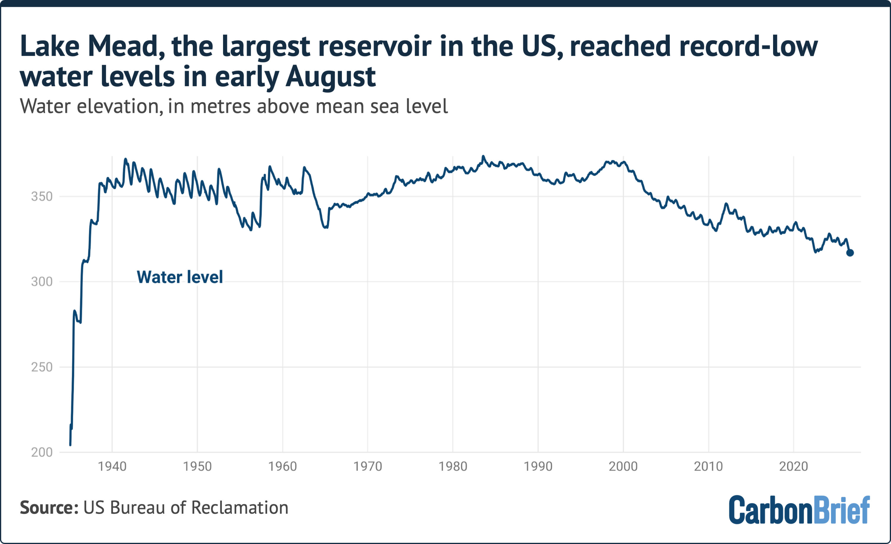
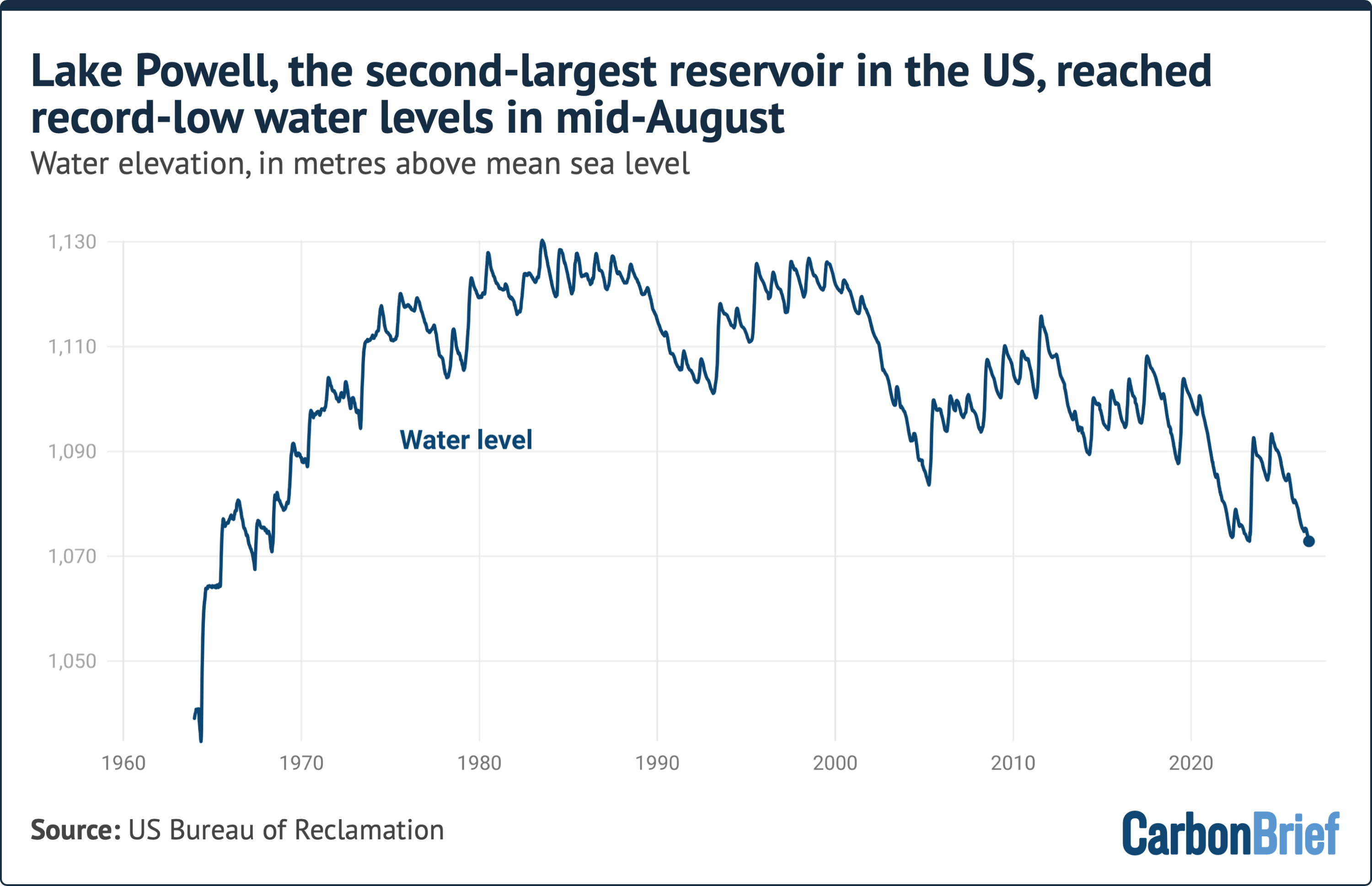
On August 7, Lake Mead, the largest reservoir in the United States, established a new historic low when its water elevation dropped to 317.11 meters above mean sea level. Barely a week later, on August 15, Lake Powell—the nation’s second-largest reservoir—followed suit, reaching an all-time low elevation of 1,072.87 meters.
+-----------------------------------------------------------------------------------+
|                            COLORADO RIVER RESERVOIR SYSTEM                        |
|                                                                                   |
|   +------------------------------------+    +---------------------------------+   |
|   |            LAKE POWELL             |    |            LAKE MEAD            |   |
|   |  (Second-Largest US Reservoir)     |    |    (Largest US Reservoir)       |   |
|   |                                    |    |                                 |   |
|   |  Full Pool:   1,127.76 meters      |    |  Full Pool:   347.60 meters     |   |
|   |  Record Low:  1,072.87 meters      |    |  Record Low:  317.11 meters     |   |
|   |  (Recorded: August 15)             |    |  (Recorded: August 7)           |   |
|   +------------------------------------+    +---------------------------------+   |
|                                                                                   |
|   Combined Storage Potential: ~68 km³ (~1.5 years of contiguous US domestic supply) |
|   System Dependencies: 40M people | 5.5M acres (22,258 km²) of farmland             |
+-----------------------------------------------------------------------------------+
This twin collapse in water storage underscores a compounded systemic failure driven by three interlocking pressures: rapid regional demographic growth, structural over-consumption, and severe human-induced climate change. Experts caution that with months remaining before the spring mountain snowpack begins to melt, reservoir levels will continue their downward trajectory through early spring, pushing the region’s water infrastructure toward critical operational thresholds.
Detailed Chronology of the Decline
The drop in water levels across Lake Mead and Lake Powell represents the culmination of a multi-decade depletion process rather than a sudden anomaly.
Lake Mead: A Century-Long Trajectory
1935: Lake Mead began filling following the completion of the Hoover Dam. Designed to create a vast buffer for downstream agricultural and municipal needs, its maximum capacity ("full pool") was established at 347.60 meters above mean sea level.
Late 20th Century: For decades, the reservoir maintained robust storage buffers, absorbing seasonal variations and prolonged dry spells.
2000–Present: Driven by the onset of a regional megadrought, water extraction systematically outpaced natural replenishment, initiating a continuous multi-decade decline.
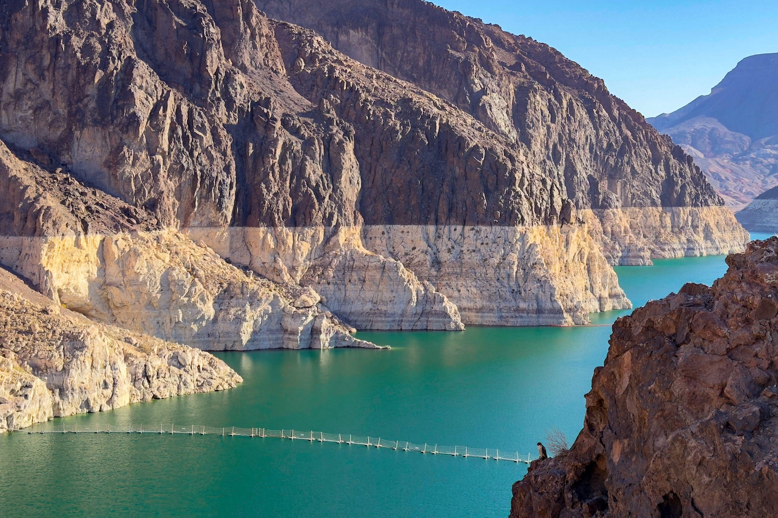
August 7: Lake Mead officially broke its historical record low, registering a water surface elevation of 317.11 meters—over 30 meters below its full pool capacity.
LAKE MEAD WATER ELEVATION TRAJECTORY (Meters Above Sea Level)
========================================================================
Full Pool Target: 347.60 m ---------------------------------------------

                                   2000s Megadrought Onset

                                   ---> August 7 Record Low: 317.11 m
========================================================================
Lake Powell: The Shrinking Upper Basin Buffer
1963: Created by the construction of the Glen Canyon Dam in northern Arizona, Lake Powell was engineered as the Upper Colorado River Basin’s primary storage safeguard, with a full-pool elevation target of 1,127.76 meters.
1980s: Lake Powell reached maximum operating capacity multiple times during extraordinarily wet hydrological cycles in the early-to-mid 1980s.
1990s–2020s: The reservoir has failed to reach full pool since the 1980s. Water levels eroded under sustained extraction demands and diminished upstream runoff.
August 15: Lake Powell reached its new historical minimum of 1,072.87 meters above sea level, breaking its previous low-water mark set just days prior.
Hydrogeologists and climate scientists emphasize that this dual decline will persist through autumn and winter. As Dr. Jack Schmidt, a senior research scientist at Utah State University’s Center for Colorado River Studies, pointed out, the basin faces a prolonged window of drawdown:
"The big dilemma of the moment is that we’re only in the middle of August, and we have no assurance of what the coming winter will be. The only thing we can be sure of is that we will be depleting overall total basin reservoir storage from now until, roughly, early April."
Supporting Context & Hydrological Metrics
At full operating capacity, Lakes Mead and Powell hold a combined total of roughly 68 cubic kilometers (km³) of water. This capacity is equivalent to nearly 1.5 years of domestic household water consumption across the entire contiguous United States. Today, the reservoirs hold only a fraction of that volume.
+-----------------------------------------------------------------------------------+
|                        COLORADO RIVER BASIN AT A GLANCE                           |
+-----------------------------------------------------------------------------------+
|  Total Municipal Reliance    |  ~40 million residents                             |
+------------------------------+----------------------------------------------------+
|  Agricultural Footprint      |  5.5 million acres (~22,258 km²)                    |
+------------------------------+----------------------------------------------------+
|  Regional Population Growth  |  +15 million residents (+60%) since 1992           |
+------------------------------+----------------------------------------------------+
|  Streamflow Reduction        |  ~20% drop in Upper Basin flow since early 1900s   |
+------------------------------+----------------------------------------------------+
|  Anthropogenic Climate Share |  ~50% of streamflow loss & megadrought intensity   |
+------------------------------+----------------------------------------------------+
Systemic Demands and Demographic Expansion
The Colorado River basin supports major metropolitan hubs, including Los Angeles, Phoenix, Las Vegas, San Diego, Denver, and Salt Lake City interconnects.
Population Pressures: Since 1992, the number of individuals relying on the Colorado River for municipal water supplies grew by 15 million people—a 60% increase.
Agricultural Foundations: The river irrigates approximately 5.5 million acres (22,258 square kilometers) of agricultural cropland across Colorado, Utah, New Mexico, Wyoming, Arizona, California, and Nevada. This network produces a significant portion of North America’s winter vegetables and forage crops like alfalfa and hay.
The Physics of Climate Attribution
The current storage deficit is heavily driven by shifting regional climate patterns:
Streamflow Deficits: Total streamflow along the Upper Colorado River has decreased by roughly 20% since the beginning of the 20th century. Academic research indicates that roughly half of this overall decline is directly attributable to human-caused climate change.
The 25-Year Megadrought: The Southwestern U.S. remains locked in a severe megadrought that began around the turn of the millennium—the driest multi-decade period in over 1,200 years. Scientific evaluations attribute nearly 50% of the drought’s severity between 2000 and 2018 directly to anthropogenic warming.
Evapotranspiration and Soil Moisture: Rising ambient temperatures cause snowpack to evaporate directly into the air (sublimation) and dry out mountain soils. As a result, when mountain snowpacks melt in the spring, a large portion of the runoff is absorbed by dry soil before ever reaching the river channel.
Official Statements and Policy Analysis
The ongoing water management crisis reflects a stark disconnect between environmental realities and legal frameworks. The allocation of the Colorado River was originally codified under the 1922 Colorado River Compact, an agreement negotiated during an unnaturally wet decade. As a result, rights to the river’s water were fundamentally over-allocated from the start.
Dr. Schmidt highlights the structural split between climate dynamics and institutional governance:
"There’s an ultimate cause of the present water crisis, and there’s a proximate cause. The ultimate cause is a warming climate, a warming planet and a pretty clear correlation between warming conditions and decreased runoff in the Colorado River Basin."
"The proximate cause is that in this messy democratic republic of ours, big policy decisions that match the variability of the climate occur painfully slowly—with intense political negotiations—and only incrementally."
                 +---------------------------------------+
                 |    PRIMARY DRIVERS OF WATER CRISIS    |
                 +---------------------------------------+
                                     |
           +-------------------------+-------------------------+
           |                                                   |
           v                                                   v
+-----------------------+                           +-----------------------+
|    ULTIMATE CAUSE     |                           |    PROXIMATE CAUSE    |
| Global Planet Warming |                           | Slow-Moving Governance|
| Shifts in Snowpack    |                           | Inter-State Friction  |
| Reduced River Runoff  |                           | Incremental Reforms   |
+-----------------------+                           +-----------------------+
Federal Regulatory Intervention
On July 31, the U.S. Bureau of Reclamation—the federal agency tasked with managing water resources across the American West—published a comprehensive Environmental Impact Statement (EIS). This document evaluates potential post-2026 operational strategies for Lakes Powell and Mead, when the current operational guidelines are set to expire.
While the formal post-2026 management strategy has not been finalized, the EIS indicates that federal authorities may mandate deep, mandatory reductions in municipal and agricultural deliveries across lower and upper basin states. However, analysts note that administrative adjustments alone cannot offset systemic aridity. As Dr. Schmidt observed regarding the Bureau’s proposed options:
"They acknowledge it won’t work if we just stay critically dry, and of course every climate model for the 21st century, especially with a continually warming planet, says that that’s exactly what’s going to happen."
Future Outlook & Systemic Risks
As Lakes Powell and Mead approach historically unprecedented low elevations, the American Southwest faces two immediate structural threats: the potential loss of hydroelectric generation and the risk of reaching "dead pool" conditions.
+-----------------------------------------------------------------------------------+
|                           INFRASTRUCTURE THRESHOLDS                               |
+-----------------------------------------------------------------------------------+
|  OPERATIONAL POOL     | Water levels allow normal releases and power production.  |
+-----------------------+-----------------------------------------------------------+
|  MINIMUM POWER POOL   | Water drops below hydroelectric penstocks. Power          |
|                       | generation ceases entirely across regional grids.          |
+-----------------------+-----------------------------------------------------------+
|  DEAD POOL            | Water drops below lowest gravity-fed outlets. Downstream  |
|                       | flow stops entirely without artificial pumping.           |
+-----------------------+-----------------------------------------------------------+
Critical Infrastructure Risks
Hydroelectric Impairment: Glen Canyon Dam (Lake Powell) and Hoover Dam (Lake Mead) generate billions of kilowatt-hours of clean electricity annually for regional power grids. If water levels drop below the intake penstocks—reaching the "minimum power pool"—hydroelectric generation will cease entirely, destabilizing the regional energy grid.
Dead Pool Risk: If water levels decline past minimum power pools to "dead pool" status, water can no longer flow downstream through Glen Canyon or Hoover dams via natural gravity. This would disrupt water delivery to Southern California, Arizona, Nevada, and northern Mexico.
Post-2026 Policy Landscape
The record lows of August mark a decisive turning point for water management in North America. State leaders, Native American tribes, municipal water authorities, and agricultural districts must establish a new operational framework before existing agreements expire at the end of 2026.
Adapting to this new reality will likely require permanent, systemic reductions in water usage. Measures under consideration include aggressive fallowing of agricultural lands, expensive investments in urban wastewater recycling, large-scale removal of non-functional turf, and strict enforcement of lower allocation caps. Without significant reductions in water consumption across all sectors, the Colorado River system risks perpetual crisis, leaving the 40 million people who depend on it highly vulnerable to an increasingly arid climate.