On the morning of 26 August, a catastrophic flash flood swept through the high-altitude border region dividing the Nepalese Himalaya and the Tibetan Plateau in China. The disaster claimed the lives of more than 1,300 people, with thousands more reported missing across devastated mountain settlements.
Initial reports pointed to a conventional glacial lake outburst or a sudden glacial collapse. However, an exhaustive analysis of satellite imagery, drone surveillance, high-resolution thermal data, and global seismic records revealed a far more complex mechanism: a massive "multi-hazard cascade." The event was initiated by a structural failure of deep-seated bedrock high on the slopes of Mount Langtang-Lirung, which brought down an entire glacier along with millions of tons of mountain wall.
       [ 5,200m Elevation ]
   Bedrock & Glacier Structural Failure
                 │
                 ▼
   Free-fall down 2,200m vertical drop
                 │
                 ▼
   Pulverization & Debris Lake Formation (3,000m)
                 │
                 ▼
   Catastrophic Dam Breach (30 km/h Surge)
                 │
                 ▼
 Downstream Inundation (Trishuli & Bhote Koshi Valleys)
While climate skeptics quickly seized upon the bedrock origin to argue that anthropogenic climate change played no role, glaciologists and geomorphologists have presented a starkly different conclusion. High Mountain Asia is experiencing accelerated, elevation-dependent warming. Decades of atmospheric warming have thawed deep permafrost—the binding "glue" of high-alpine rock faces—and caused extensive glacial retreat, stripping away the mechanical support that stabilizes these steep mountain walls. This disaster serves as a grave warning regarding the compound risks facing mountain communities in a rapidly warming world.
Detailed Chronology of the Disaster
Phase I: The Trigger and Seismic Impact (26 August, 08:37 Local Time)
The crisis began at approximately 08:37 AM Nepal local time on 26 August. A vast section of mountain bedrock beneath a high-altitude glacier on Mount Langtang-Lirung gave way at an elevation of approximately 5,200 meters above sea level.
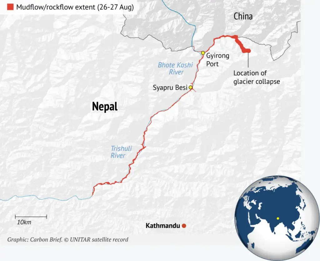
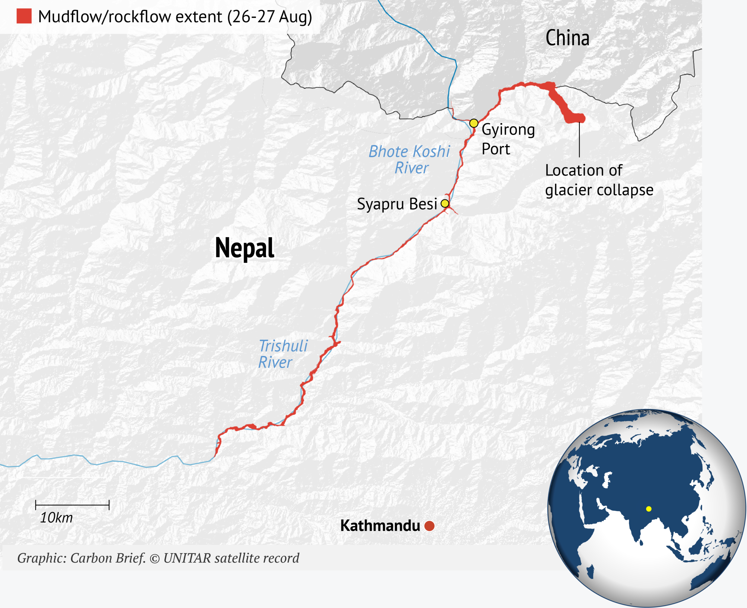
The collapsing mass—comprising millions of cubic meters of solid rock, basal ice, and overlying glacial material—plunged nearly 2,200 meters vertically into the valley floor below, striking the valley at an elevation of 3,000 meters.
+-----------------------------------------------------------------------+
|                       DISASTER TIMELINE SUMMARY                       |
+-------------------+---------------------------------------------------+
| Date / Time       | Event Stage                                       |
+-------------------+---------------------------------------------------+
| 26 Aug, 08:37     | Bedrock collapse at 5,200m on Langtang-Lirung;    |
|                   | USGS registers mag 5.2 seismic equivalent.        |
+-------------------+---------------------------------------------------+
| 26 Aug, 09:00     | Impact pulverizes rock/ice; temporary debris dam   |
|                   | forms across Lhende Khola river basin.            |
+-------------------+---------------------------------------------------+
| 26 Aug, Morning   | Debris dam breaches; surge moves at 30 km/h;      |
|                   | Trishuli River rises 9m in 30 mins at Galchhi.    |
+-------------------+---------------------------------------------------+
| 26 Aug, 13:00     | Flood crest reaches Mugling (>130 km downstream). |
+-------------------+---------------------------------------------------+
| 28 Aug            | Secondary barrier lake in Tibet breaches,         |
|                   | sending a second destructive wave downstream.     |
+-------------------+---------------------------------------------------+
The kinetic energy of the impact generated ground tremors detected by seismic networks worldwide. The United States Geological Survey (USGS) initially flagged the event as a magnitude 4.4 earthquake. Upon further calibration of the seismic signatures, USGS updated the assessment, clarifying that the signal was generated by a massive ice-rock avalanche and subsequent debris flow, releasing energy equivalent to a magnitude 5.2 earthquake.
Phase II: Pulverization and Dam Formation
Upon impacting the valley basin, the mountain mass pulverized into a dense mixture of fractured rock, melted ice, mud, and liquid water. The landslide slammed directly into the Lhende Khola—a high-altitude river running along the border between Nepal and China (known in Tibet as the Donglin Tsangpo).
Downstream, this water system feeds the Bhote Koshi in Nepal and the Poiqu (or Poqu) in China, eventually merging into the larger Trishuli River network. The sheer volume of incoming debris momentarily impounded the river, creating an unstable temporary "debris lake."
Phase III: The Initial Downstream Surge
The temporary debris dam failed shortly after forming. A hyper-concentrated flow of water, boulders, and thick mud burst through the valley, traveling downstream at speeds up to 30 kilometers per hour (19 miles per hour).
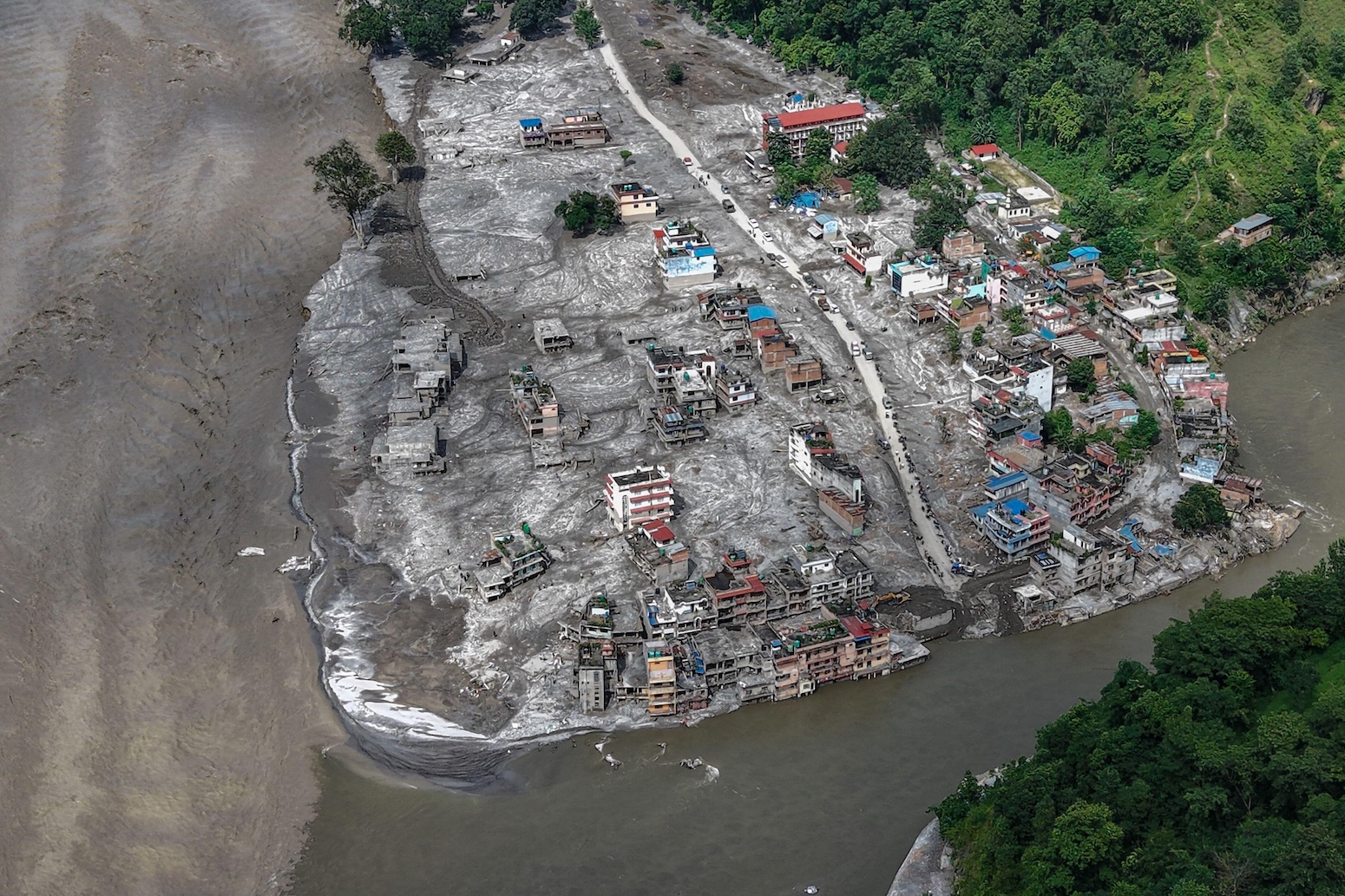
According to data compiled by the Center for Land Surface Hazards, the surge was sediment-laden and extreme in scale. In the Nepalese municipality of Galchhi, the Trishuli River rose by nine meters within just 30 minutes. By 1:00 PM local time, the crest of the flood wave reached Mugling, a major transport hub more than 130 kilometers downstream from the failure site.
                  ELEVATION & HYDRAULIC PROFILE
  Elevation (m)
   5,200m ───┐ Initial Bedrock/Glacier Failure
             │
             │ [2,200m Vertical Drop]
             │
   3,000m ───┴───► Impact at Valley Floor / Debris Dam Impoundment
                   │
                   ├───► 30 km/h Downstream Flash Flood
                   │
     400m ─────────┴───► Extreme Water Level Rise (+9m at Galchhi)
Phase IV: The Secondary Breach (28 August)
The disaster evolved over several days. As glaciologist Dr. Umesh Haritashya of the University of Dayton noted, the physical hazard shifted following the initial wave on 26 August:
"The disaster wasn’t finished when the first wall of water passed. A second barrier lake, holding an estimated few million cubic meters of impounded water, formed higher up near a river confluence in Tibet."
On 28 August, this secondary barrier lake breached its walls, sending a second wave down the river valley, overtopping damaged defense structures, and hindering search-and-rescue operations.
Deconstructing the Physics: Bedrock Failure vs. Glacial Collapse
The rapid evolution of scientific understanding surrounding this event highlighted the complexities of mountain geomorphology. Initial news reports characterized the disaster as a pure "glacial collapse," drawing comparisons to classic Glacial Lake Outburst Floods (GLOFs). Subsequent satellite imagery forced a significant re-evaluation.
                    ANATOMY OF A MULTI-HAZARD CASCADE

    +-------------------------------------------------------+
    |               LONG-TERM CLIMATE DRIVERS               |
    |   • Elevation-Dependent Warming                           |
    |   • Deep Permafrost Degradation (Loss of Rock "Glue")  |
    |   • Glacial Retreat & Loss of Buttressing Pressure     |
    +---------------------------+---------------------------+
                                |
                                v
    +-------------------------------------------------------+
    |                   TRIGGER EVENT                       |
    |   • Peak Summer Heatwave (Warmest August Week on Record) |
    |   • Elevated Pore-Water Pressure in Rock Fractures     |
    |   • Structural Failure of Bedrock at 5,200m Elevation  |
    +---------------------------+---------------------------+
                                |
                                v
    +-------------------------------------------------------+
    |                 CASCADING MECHANISMS                  |
    |   • Bedrock Landslide Entrains Overlying Glacier Ice  |
    |   • Kinetic Impact Pulverizes Mass into Water/Mud/Rock|
    |   • Temporary River Impoundment & Outburst Flooding   |
    +-------------------------------------------------------+
Dr. Kristen Cook, a geomorphologist at Université Grenoble Alpes, noted that early satellite passes missed the sheer depth of the detachment zone:
"The rock that the glacier was sitting on collapsed… It was a much larger collapse than we were initially able to see in the satellite imagery."
Dr. Jakob Steiner, a geoscientist at the University of Graz, explained the distinction between a glacial failure and a rock-slope structural breakdown:
"It was not a glacier that collapsed. It was the mountain below the glacier that collapsed and the glacier had no other chance but to go with it because it was sitting on top of it. The trigger for that is something that we are not 100% certain about, but, in the end, it very much looks like simply a mechanical failure of the rock material because of stressors that have built up over a long period of time."
Prof. Bethan Davies, a professor of glaciology at Newcastle University, emphasized that large-scale bedrock failures in deglaciating environments are becoming more frequent globally:
"These massive landslides occur in mountain regions, commonly following rapid deglacierisation. Similar events happened in the Chamoli event in 2021 [in the Indian Himalaya] and in the Blatten landslide last year in Switzerland. They’ve also occurred recently in Alaska."
The presence of thick ice layers within the landslide mass transformed a localized rockfall into an extraordinary hydrological disaster. The friction generated by millions of tons of falling rock instantly melted massive volumes of embedded ice, while the entrainment of valley-floor glacial deposits supplied additional fluidized material, generating a highly destructive, hyper-concentrated slurry.
Supporting Context & Data Metrics: Climate Footprints in High Mountain Asia
To understand why a bedrock slope at 5,200 meters altitude suddenly failed, scientists examined historical climate data, thermal trends, and cryospheric retreat patterns across the Langtang catchment.
1. Elevation-Dependent Warming (EDW)
While average global temperatures have increased by approximately 1.4°C since pre-industrial times, High Mountain Asia exhibits pronounced Elevation-Dependent Warming (EDW)—a phenomenon where higher elevations warm faster than lowlands due to snow-albedo feedbacks and water vapor adjustments.
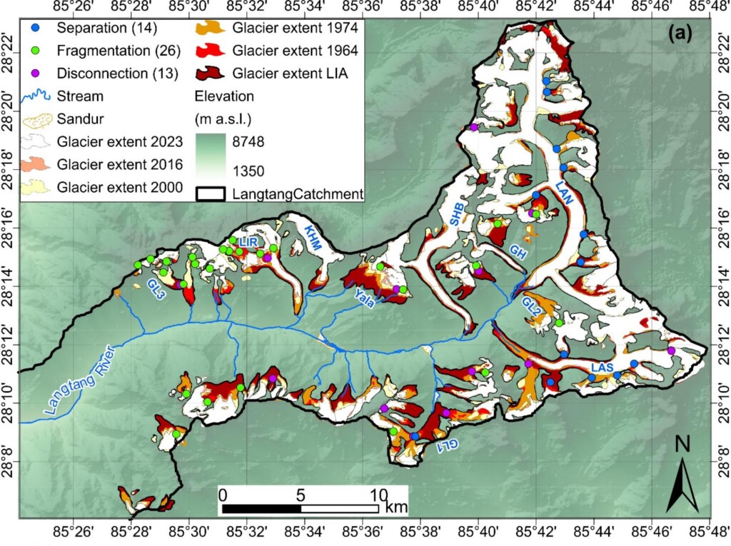
A study published in Global and Planetary Change analyzed historical weather records and satellite data across the Langtang catchment from 1960 to 2023. The findings revealed that glaciated zones above 4,000 meters elevation warmed at a rate of 0.31°C per decade—more than three times the rate recorded at lower elevation stations in the same river basin.
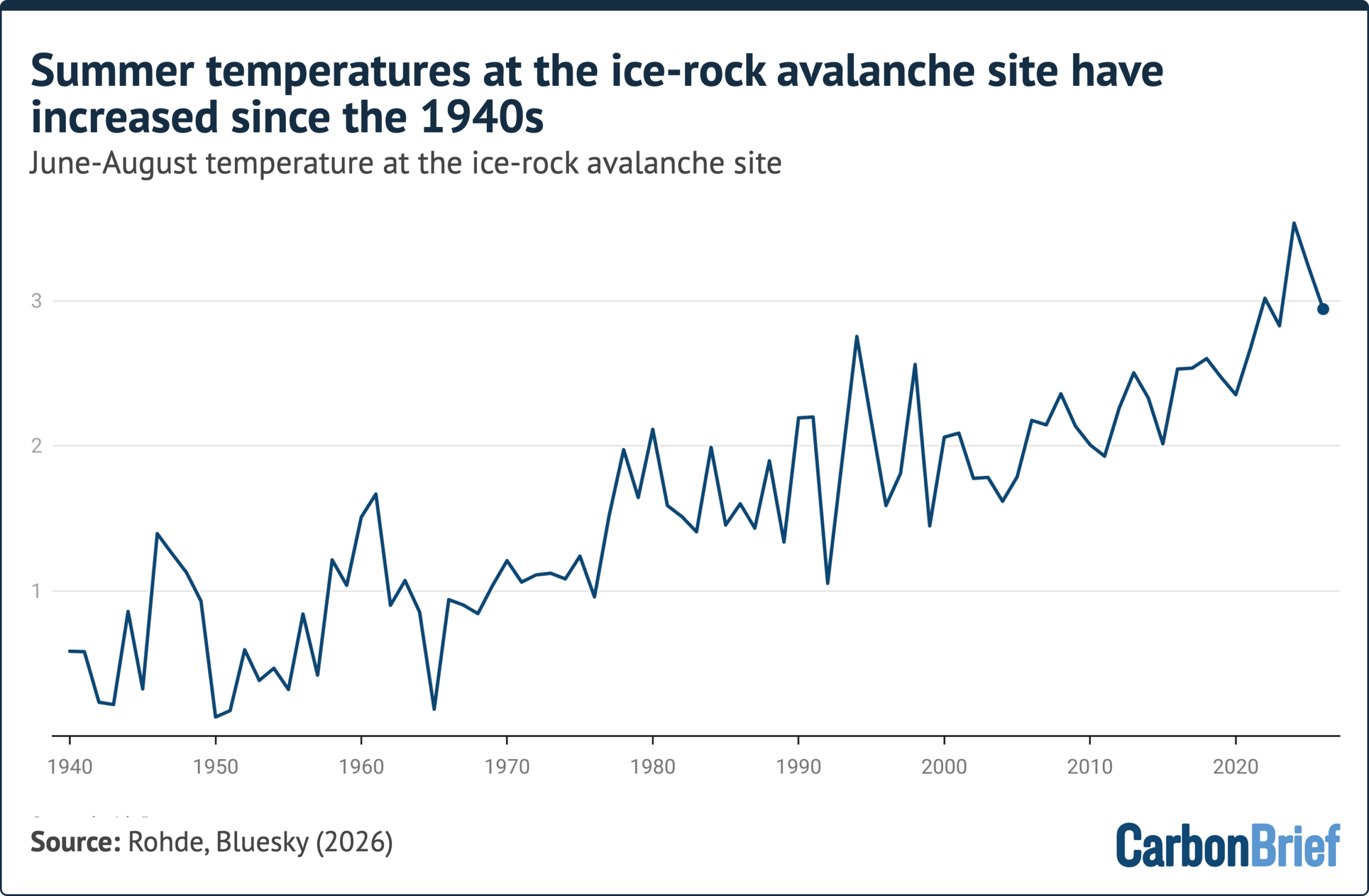
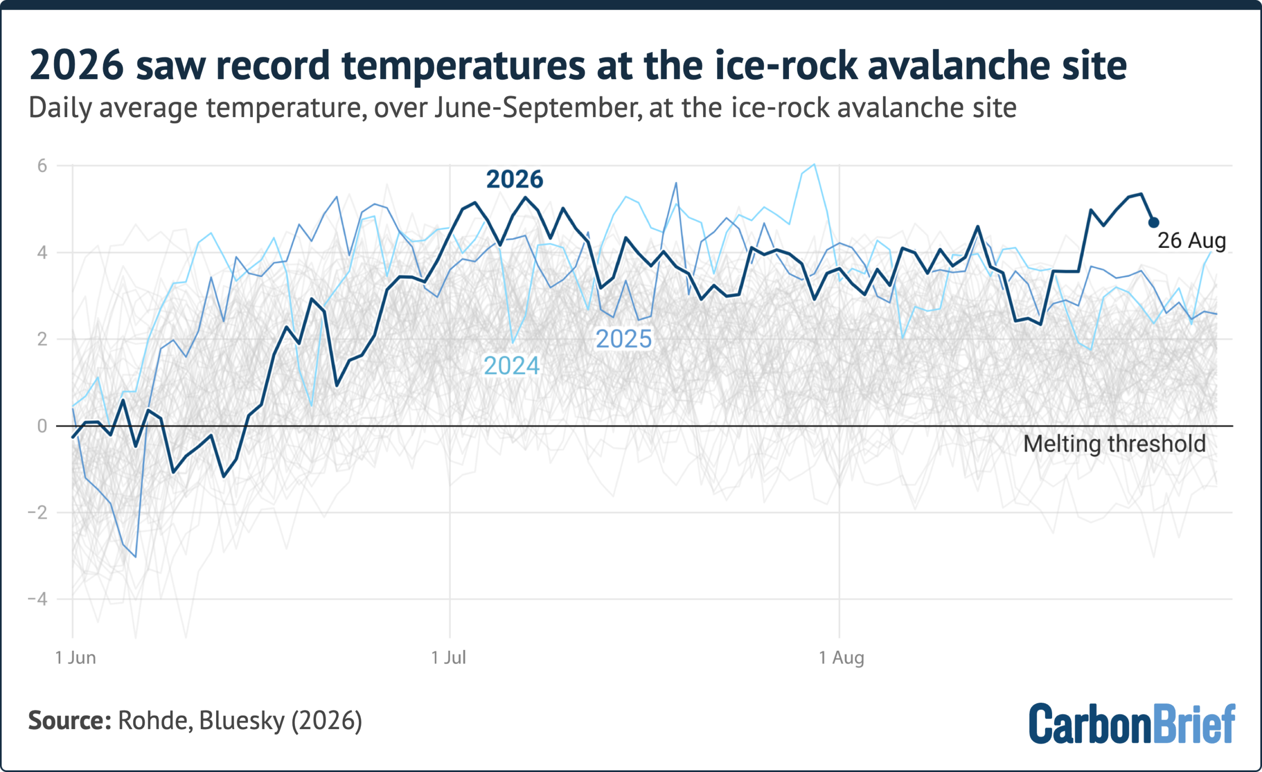
An analysis by Dr. Robert Rohde, chief scientist at Berkeley Earth, utilized ECMWF ERA5 reanalysis data to reconstruct temperature records directly at the 5,200-meter collapse site on Mount Langtang-Lirung from 1940 through 2026.
+-------------------------------------------------------------------+
|               SUMMER TEMPERATURE RECORDS AT 5,200M                |
+-------------------+-----------------------------------------------+
| Metric            | Finding / Observation                         |
+-------------------+-----------------------------------------------+
| Long-term Trend   | Continuous warming from 1940 to 2026          |
+-------------------+-----------------------------------------------+
| Summer Rank       | Summer 2026 ranked 4th warmest on record      |
| (June–August)     | (Behind 2024, 2025, and 2022)                 |
+-------------------+-----------------------------------------------+
| Pre-Event Spike   | Highest August daily temperatures recorded in |
| (Late August)     | the entire 86-year ERA5 dataset               |
+-------------------+-----------------------------------------------+
The data showed that summer temperatures at this site have been rising steadily over decades. Crucially, the days immediately preceding the 26 August collapse brought the highest August temperatures ever recorded at that altitude in the 86-year dataset.
Dr. Rohde noted on social media:
"Given the warming trend, this Nepali glacier had probably been thinning and weakening for years, or even decades. But it ultimately failed during the warmest week in one of its warmest years on record. It would be a hell of a coincidence if global warming wasn’t at least partially to blame."
3. Deep Permafrost Degradation
Permafrost acts as a structural binding agent in high-altitude environments, freezing fractures and rock joints together. When temperatures remain consistently above freezing at high elevations, permafrost thaws, introducing water into subsurface rock joints and building hydro-dynamic pressure.
Dr. Jakob Steiner highlighted the long-term monitoring data gathered by his team since 2014:
"It is pretty clear the permafrost has been thawing very actively at elevations as high as 5,200 metres above sea level for many years… This means that the ground has, over the last decades, moved from being in a solid state into—at least, periodically during the warm season—patchy ground where some is frozen and some isn’t. If you have frozen ground next to non-frozen ground, you have dynamics happening between that because there are different densities and there’s movement happening, which is conducive to structural failure."
Prof. Bethan Davies added:
"This permafrost acts as a glue to hold together the rocks and, as it melts, the rock can become weakened. Sources of the water include melting permafrost and meltwater from the overlying glacier. We know that this event happened during a period of warmth, but in the absence of heavy precipitation, pointing to ice melt as the source of water."
A 2025 inventory of rock-ice avalanches across High Mountain Asia published in Landslides revealed that over two-thirds of all major collapses initiated in zones where permafrost degradation was actively occurring.
4. Glacial Retreat and Unbuttressing
When a glacier melts and recedes, it exposes the steep rock slopes that it once supported. This removal of structural support—known as unbuttressing—leaves rock faces vulnerable to gravitational failure along pre-existing joints.
                    THE UNBUTTRESSING MECHANISM

       HISTORICAL STATE                     CURRENT STATE
   (Glacial Support Intact)             (Post-Retreat Instability)

      /  │                                 /  │
     /   │ Glacial                        /   │ Hydrostatic
    /    │ Buttress                      /  Approx. Pressure
   /     │ Pressure                     /  450m │ (Meltwater)
  / Glacier│                           / Retreat│
 /_______│                            /_________│ ▼
[Solid Bedrock Wall]                 [Unsupported Fractured Wall]
According to satellite assessments highlighted by Prof. Maria Shahgedanova of the University of Reading, the glacier resting atop the failure site on Langtang-Lirung had retreated by approximately 450 meters between 1990 and 2020.
Research published in Global and Planetary Change documented that glacier area loss across the entire Langtang catchment accelerated more than fourfold from 1964 to 2023, with melting rates increasing sharply after 2000. This structural loss left the adjacent rock walls unsupported, setting the stage for eventual failure.
Official Statements, Economic Impact, and Political Controversies
Political Reactions and Damage Estimates
In the days following the event, Nepalese Prime Minister Balendra Shah framed the disaster as a clear signal of escalating risks in the region:
"This is a serious signal that the risks we must bear in the Himalayan region are increasing due to climate change."
On 4 September, Dharma Raj Upreti, chief of Nepal’s National Disaster Risk Reduction and Management Authority (NDRRMA), released an initial economic assessment indicating that property and infrastructure losses totaled at least $2.5 billion. The cost of basic emergency restoration—rebuilding swept-away border crossings, replacing destroyed bridges, establishing temporary shelters, and restoring power—was estimated at an additional $53 million.
Pseudoscience and the Skeptic Counter-Debate
As scientists clarified that the disaster originated from a bedrock collapse rather than a surface glacial collapse, climate skeptics used the nuance to claim that climate change was uninvolved. Figures such as Dr. Matthew Wielicki and commentator Matt Ridley argued in online posts and opinion pieces that a bedrock failure disproved a connection to atmospheric warming.
Glaciologists and climate scientists responded directly to these claims. As Prof. Davies noted, focusing solely on the rock failure ignores the fundamental mechanics of the disaster:
"This would have been a much less significant tragedy if it had been just a rock-slope failure. The initial landslide took a mixture of rock and ice into a valley that contains buried ice as well, providing the water that resulted in the hyperconcentrated flow, which took so many lives."
Future Outlook & Scientific Consensus
The Limits and Realities of Attribution Science
The event raised questions regarding classical extreme-event attribution. Traditional attribution studies rely on statistical models comparing the likelihood of weather events—such as heatwaves or extreme rainfall—in worlds with and without human-caused greenhouse gas emissions.
Applying these methods to compound, multi-hazard geomorphic collapses remains extraordinarily complex. As Dr. Zeke Hausfather, climate scientist and contributor to Carbon Brief, explained:
"A definitive single-event attribution of this disaster may never be possible due to the messy causality of rock-ice avalanches. However, both the existing scientific literature and essentially every scientist working on these hazards point in the same direction—warming is making such events more likely in the Himalaya."
+-------------------------------------------------------------------+
|           ATTRIBUTION PERSPECTIVES ON HIMALAYAN CASCADES          |
+--------------------+----------------------------------------------+
| Expert             | Key Takeaway                                 |
+--------------------+----------------------------------------------+
| Dr. Zeke Hausfather| Causality is too complex for single-event    |
|                    | attribution, but overall likelihood rises.   |
+--------------------+----------------------------------------------+
| Dr. Jakob Steiner  | Mechanically possible without climate change,|
|                    | but probability is elevated by warming trends.|
+--------------------+----------------------------------------------+
| Prof. Bethan Davies| Multiple drivers exist, but warming trends   |
|                    | destabilize high mountain systems.           |
+--------------------+----------------------------------------------+
Dr. Steiner expanded on this distinction:
"The physics of it is not something that has been made possible by climate change. This could have happened without it. But the chance of it happening—and the likelihood of it happening five years after a previous, similar event [in Chamoli]—we, as the scientific community, can be pretty confident about that [being increased because of a changing climate]. This is because so many of the changes that we know are related to climate change can potentially drive the build-up to eventual failure."
Systemic Risk across the Hindu Kush Himalaya
The International Centre for Integrated Mountain Development (ICIMOD) has warned that glaciers across the 3,500-kilometer-long Hindu Kush Himalaya (HKH) region are melting at unprecedented rates. The region feeds ten major river basins that provide water to nearly 2 billion people downstream.
As mountain permafrost continues to thaw and high-altitude glaciers retreat, the structural stability of the entire range will keep degrading. This shift elevates the risk not only for GLOFs, but for compound cascades where bedrock failures entrain ice, impound rivers, and trigger massive flash floods.
To adapt to these expanding risks, scientists, regional authorities, and international bodies emphasize several priorities:
Integrated Multi-Hazard Early Warning Systems: Installing real-time seismic, hydrological, and acoustic sensor arrays along high-risk river valleys to detect slope failures and alert downstream communities within minutes.
High-Altitude Cryospheric Monitoring: Utilizing targeted satellite imagery and thermal mapping to track permafrost degradation and identify fracturing bedrock above melting glaciers.
Climate-Resilient Infrastructure Design: Re-evaluating the placement of hydropower dams, highway corridors, and bridges in glacial river basins to account for sudden, extreme sediment flows and transient water levels.
Prof. Davies concluded:
"A careful attribution study is needed, but it is hard to argue that the rapidly warming climate is not having an effect in these regions. A single event may have multiple drivers, but we are seeing an increase in these events and are likely to see more as the permafrost and glacier melt continues."