Executive Overview
On the morning of 26 August, a catastrophic flash flood swept through the high-altitude borderlands connecting Nepal and the Chinese autonomous region of Tibet. The sudden surge destroyed communities, tore through vital infrastructure, and claimed more than 1,300 lives, with thousands more reported missing downstream.
Initial reports attributed the tragedy to a conventional glacial lake outburst flood (GLOF) or a direct glacier collapse. However, comprehensive scientific investigations—utilizing high-resolution satellite imagery, seismic telemetry, and regional climate data—have revealed a far more complex phenomenon: a multi-hazard cascade.
The disaster began high on the slopes of Mount Langtang-Lirung, where a massive section of underlying bedrock collapsed, taking an overlying glacier with it. This massive landslide plunged more than 2,000 vertical meters, pulverizing ice and rock into a high-velocity slurry that choked transboundary river systems and breached multiple temporary debris dams.
[Bedrock Failure at 5,200m]
         │
         ▼ (2,000m Fall)
[Ice/Rock Pulverization & Debris Lake]
         │
         ▼ (Lake Breach)
[High-Velocity Slurry: 30 km/h Surge]
         │
         ▼ (River Network Choked)
[Widespread Transboundary Devastation]
While climate skeptics seized upon the bedrock failure to downplay the influence of anthropogenic warming, glaciologists and geomorphologists emphasize that cryospheric degradation—specifically rapid permafrost thaw, severe glacier retreat, and record-breaking alpine temperatures—substantially destabilized the mountain.
Economic damages are estimated to exceed $2.5 billion, underscoring the acute vulnerability of the Hindu Kush Himalaya (HKH) region to climate-accelerated disasters.
Detailed Chronology & Reconstruction of Events
CHRONOLOGY OF DISASTER
========================================================================
26 Aug, 08:37 AM  ── Bedrock & glacier collapse on Langtang-Lirung.
                   ── USGS detects M4.4 seismic shock (later revised
                      to M5.2-equivalent debris avalanche).
26 Aug, Morning   ── Debris lake forms on valley floor; subsequently
                      bursts, releasing high-velocity mud/water surge.
26 Aug, 01:00 PM  ── Flood wave reaches Mugling (130 km downstream);
                      Trishuli River rises 9 m in 30 minutes at Galchhi.
28 Aug            ── Secondary barrier lake in Tibet bursts, sending
                      a second destructive surge downstream.
04 Sep            ── Official loss estimates published ($2.5B+ total).
========================================================================
The Initial Instability (26 August, 08:37 AM Local Time)
The trigger occurred high in the Nepalese Himalaya on the sheer faces of Mount Langtang-Lirung. At approximately 5,200 meters above sea level, a massive structural block of deep bedrock fractured and sheared away from the mountain core.
Sitting directly atop this rock mass was an alpine glacier, which was swept downward in the failure. The combined volume of rock, ice, and subglacial sediment fell nearly 2,200 vertical meters, crashing onto the valley floor at an elevation of 3,000 meters.
The mechanical force of this impact generated localized ground motion so intense that the U.S. Geological Survey (USGS) automatically recorded a magnitude 4.4 earthquake at 08:37 AM local time. Subsequent analysis of the seismic signature led the USGS to reclassify the signal not as a tectonic quake, but as an ice-rock avalanche and mass flow equivalent to a magnitude 5.2 seismic event.
Lake Formation and Primary Outburst Surge
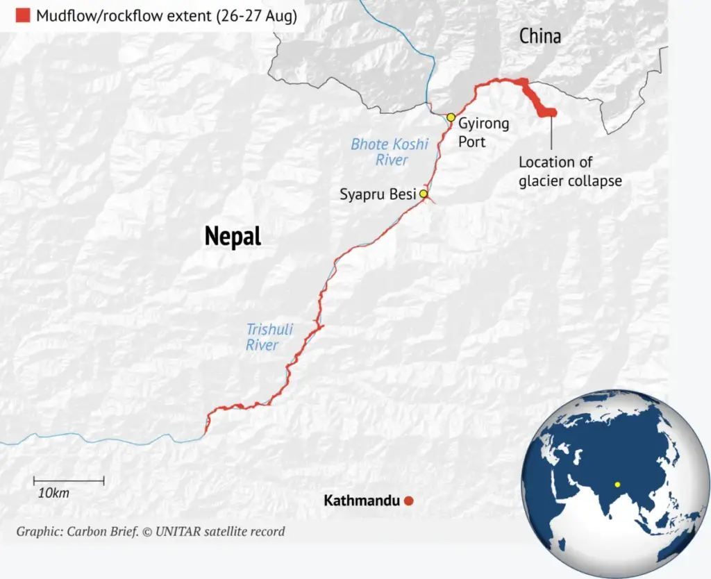
Upon impacting the valley floor, the kinetic energy of the collapse pulverized the ice and rock matrix, flash-melting portions of the ice and mixing with loose valley sediments. This dense material slammed into the Lhende Khola river—a transboundary watercourse known as the Donglin Tsangpo in China, which feeds into the Bhote Koshi and Trishuli river systems in Nepal.
The initial mass movement temporarily dammed the river channel, creating a temporary debris lake. Within hours, the impounded water overtopped and breached this unstable dam.
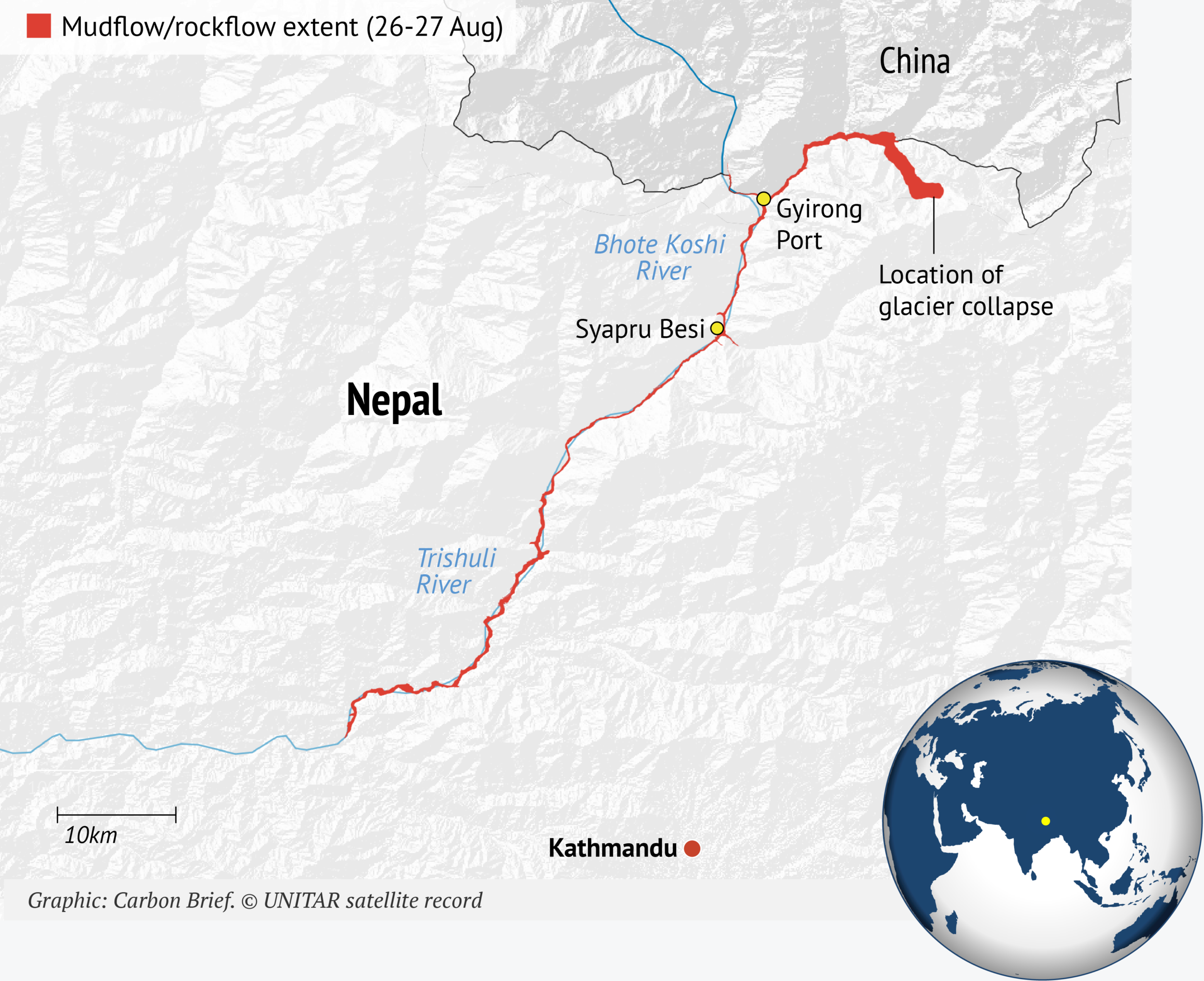
According to findings by the HiRisk scientific consortium, the resulting floodwave surged downstream at speeds reaching 30 kilometers per hour (19 mph).
- In Galchhi, a municipality in Nepal’s Dhading district, the Trishuli River surged upward by nine meters in just 30 minutes.
- By 1:00 PM local time, the flood crest reached the town of Mugling, more than 130 kilometers downstream from the collapse site, sweeping away bridges, roads, and border posts along its path.
+-----------------------------------------------------------------------+
|                       TRANSBOUNDARY RIVER SYSTEM                      |
+-----------------------------------------------------------------------+
|  Langtang-Lirung Massif (Collapse Site: 5,200m)                       |
|    │                                                                  |
|    ▼                                                                  |
|  Lhende Khola / Donglin Tsangpo (Border Zone)                         |
|    │                                                                  |
|    ├───────────────────────────────┐                                  |
|    ▼                               ▼                                  |
|  Bhote Koshi River (Nepal)     Poiqu / Poqu River (Tibet, China)      |
|    │                                                                  |
|    └───────────────────────────────┤                                  |
|                                    ▼                                  |
|                              Trishuli River                           |
|                                    │                                  |
|                                    ▼                                  |
|                              Ganges Basin                             |
+-----------------------------------------------------------------------+
The Secondary Barrier Breach (28 August)
The destruction extended beyond the initial wave. As explained by Dr. Umesh Haritashya, a glaciologist at the University of Dayton, a secondary hazard quickly developed at the confluence of two rivers in Tibetan territory prior to the Nepalese crossing.
Sediment and dislodged boulders formed a secondary "barrier lake," holding several million cubic meters of water. On 28 August, this second natural dam collapsed, sending a second major surge down the river valley. This prolonged the emergency, inundated ongoing search-and-rescue efforts, and destroyed critical access infrastructure that had survived the first wave.
Supporting Context & Technical Metrics
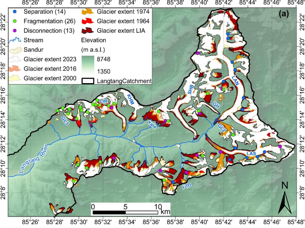
To evaluate why this high-altitude slope failed, researchers examined cryospheric changes, historical temperature trends, and structural geological dynamics in the Langtang catchment.
Key Environmental & Technical Metrics:
• High-altitude warming rate (at 4,000m+):  0.31°C per decade (1960–2023)
• Langtang glacier retreat (1990–2020):    ~450 meters
• Glacier loss rate increase:               >4-fold expansion since 2000
• River level shock (Galchhi):              +9 meters in 30 minutes
• Downstream floodwave speed:               Up to 30 km/h
• Immediate financial reconstruction cost:  $53 million
• Overall economic/infrastructure damage:   $2.5+ billion
1. Thermal Anomalies at High Altitude
While global mean surface temperatures have increased by approximately 1.4°C relative to pre-industrial baselines, high-mountain environments experience elevation-dependent warming (EDW), causing high peaks to warm considerably faster than surrounding lowlands.
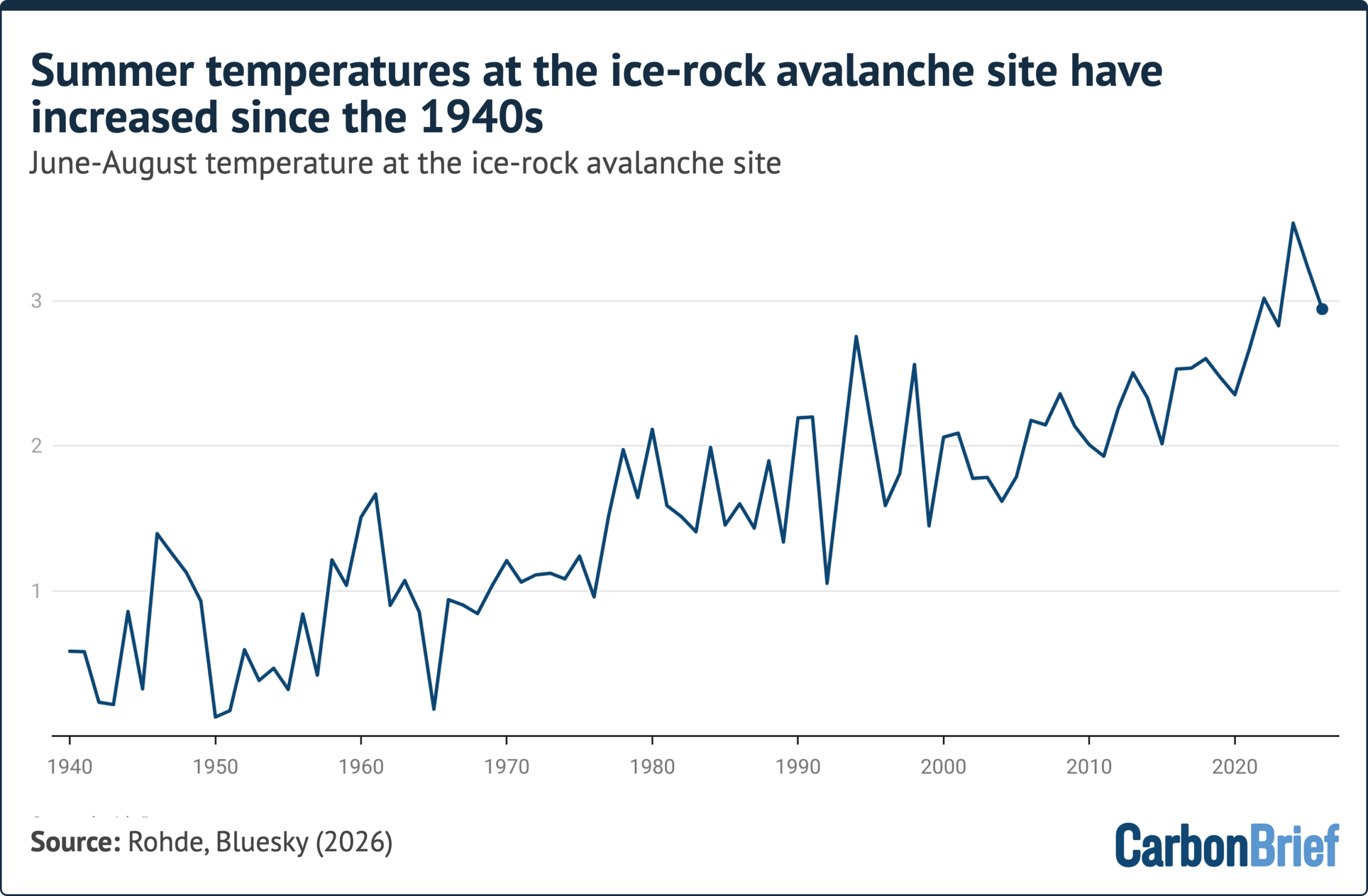
A study published in Global and Planetary Change revealed that glacial elevations in the Langtang catchment (above 4,000 meters) warmed at a rate of 0.31°C per decade between 1960 and 2023—more than triple the rate recorded at lower-elevation weather stations in the same region.
TEMPERATURE TREND AT ICE-ROCK AVALANCHE SITE (ERA5 Data Analysis)
-----------------------------------------------------------------------
• Summer (June–Aug) Baseline (1940–2026): Clear long-term warming trend.
• Summer 2026 Rank: 4th warmest summer on record (behind 2024, 2025, 2022).
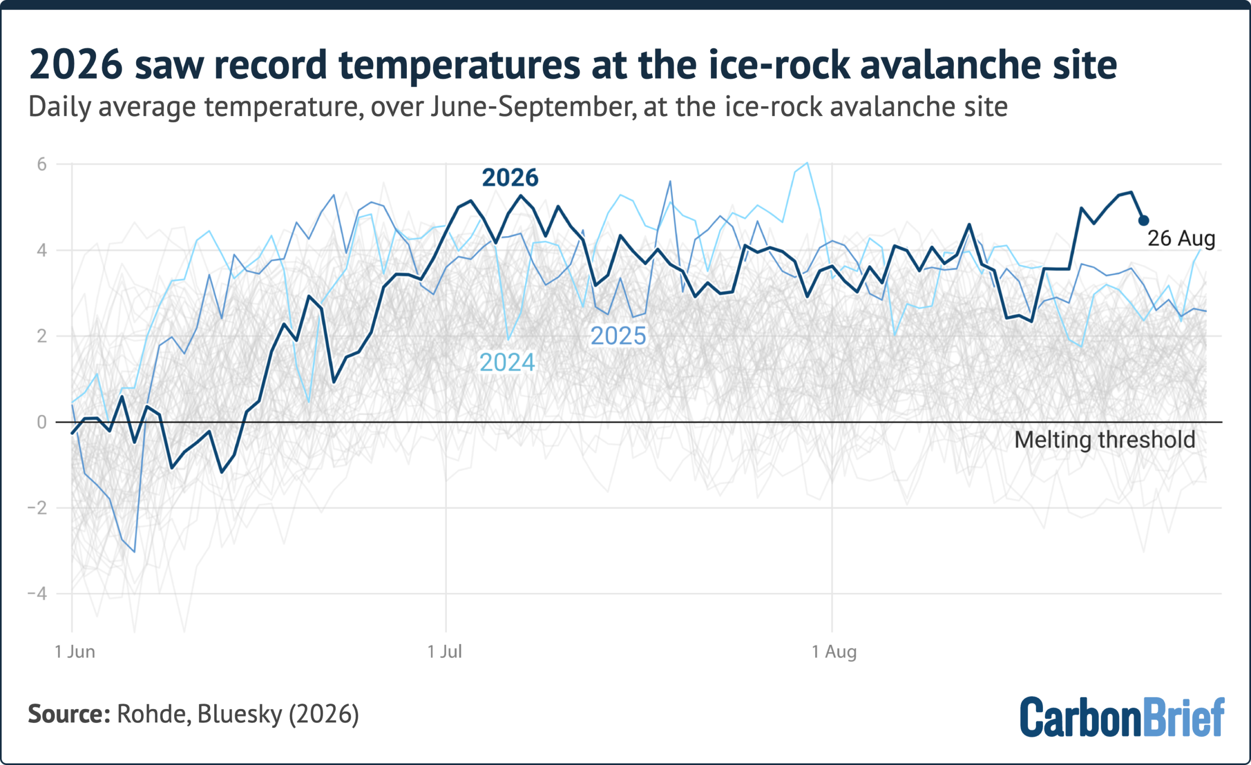
• August 2026 Heat Spike: Days preceding 26 August recorded the absolute
  highest daily temperatures ever documented for August at 5,200m.
-----------------------------------------------------------------------
Analyzing ERA5 reanalysis data at the 5,200-meter collapse site, Dr. Robert Rohde, chief scientist at Berkeley Earth, demonstrated that the days directly preceding the event registered the hottest August temperatures ever recorded at that elevation.
Rohde noted that while decades of warming had steadily thinned and weakened the ice-rock structure, the final mechanical failure occurred during the hottest week of an unusually warm summer.
       5,200m Peak Elevation
             /   <-- Record August Heat Spikes (ERA5 Data)
            /
           /      <-- Permafrost Thaw & Water Pressure
          /
         /_________ <-- Glacier Retreat (~450m) & Unbuttressing
        [ BEDROCK   ]
        [ FAILURE   ] <-- Deep Mechanical Shearing
2. Permafrost Degradation and Mechanical Failure
Geoscientists emphasize that the collapse was rooted in the degradation of high-altitude permafrost—perennially frozen ground that acts as an ice binding agent, holding fractured mountain faces together.
Dr. Jakob Steiner of the University of Graz, whose team has monitored permafrost in the region since 2014, confirmed that active thawing has been occurring at elevations up to 5,200 meters:
"The ground has, over the last decades, moved from being in a solid state into—at least periodically during the warm season—patchy ground where some is frozen and some isn’t. If you have frozen ground next to non-frozen ground, you have dynamics happening… which is conducive to structural failure."
Furthermore, as permafrost thaws and overlying glacier ice melts, high volumes of liquid water infiltrate deep rock joints. In the absence of extreme precipitation prior to the event, scientists identified surface ice melt and permafrost fluid as the primary drivers of elevated hydraulic pore pressure within the rock joints, forcing the fracture lines apart.
3. Loss of Glacial Buttressing
The long-term retreat of the glacier overlying the Langtang-Lirung slope also diminished structural support. According to Prof. Maria Shahgedanova of the University of Reading, the glacier involved in the failure had retreated by roughly 450 meters between 1990 and 2020.
When a glacier retreats and thins, it removes the heavy physical counterweight ("buttress") resting against the lower rock face. This leaves steep, weathered rock walls unsupported and increasingly vulnerable to collapse under gravity and accumulated internal stress.
GLACIER RETREAT & STRUCTURAL UNBUTTRESSING
========================================================================
HISTORICAL STATE (Pre-1990)        MODERN DEGRADED STATE (Post-2020)
---------------------------        ---------------------------------
  / Rock Slope                      / Rock Slope
 /                                 /
/ Ice  <-- Glacier supports       / Melt <-- Glacier retreats ~450m;
/Mass      lower rock wall       /   ...     buttressing weight lost;
/______                          /________   joints fill with meltwater
========================================================================
4. The Attribution Debate
Following the disaster, climate skeptics claimed that because the initial trigger was a bedrock collapse rather than a pure ice breakdown, human-driven climate change played no role.
Glaciologists quickly refuted this claim, explaining that multi-hazard cascades cannot be analyzed as isolated events.
                     ATTRIBUTION ANALYSIS
┌───────────────────────────────────────────────────────────┐
│ SINGLE-EVENT ATTRIBUTION                                  │
│ • Deterministic proof for one rock fall: EXTREMELY DIFFICULT │
│ • Lack of multi-century high-altitude baseline data       │
├───────────────────────────────────────────────────────────┤
│ SYSTEMIC RISK ATTRIBUTION                                 │
│ • Permafrost Thaw: HIGH CONFIDENCE                        │
│ • Glacial Unbuttressing: HIGH CONFIDENCE                  │
│ • Thermal Expansion/Melt Pressure: HIGH CONFIDENCE        │
└───────────────────────────────────────────────────────────┘
Prof. Bethan Davies of Newcastle University noted that a rock-slope failure alone would have been far less devastating. The presence of glacier ice and subglacial meltwater transformed what would have been a localized landslide into a mobile, liquid, hyper-concentrated slurry that travelled over 100 kilometers.
While formal attribution studies quantifying the exact anthropogenic footprint are still ongoing, glaciologists agree on the underlying physics: rising temperatures, permafrost thaw, and glacial retreat systematically increase the frequency and severity of large-scale mountain slope failures.
Official Statements, Economic Impact & Political Fallout
The human and financial damage caused by the disaster has put immense pressure on local governments and international relief agencies.
ECONOMIC LOSS BREAKDOWN
-----------------------------------------------------------------
• Total Damaged Infrastructure & Property:   ~$2.50 Billion
• Immediate Relief & Critical Restoration:   ~$53.00 Million
  - Temporary Shelter & Emergency Housing
  - Roadway Reconnection & Bridge Swaps
  - Potable Water Line Restoration
  - Grid & Hydropower Re-synchronization
-----------------------------------------------------------------
Government and Official Responses
Speaking on the disaster, Nepal’s Prime Minister Balendra Shah framed the event as an urgent international warning regarding climate vulnerability:

"This is a serious signal that the risks we must bear in the Himalayan region are increasing due to climate change."
In an assessment provided on 4 September, Dharma Raj Upreti, an official with Nepal’s National Disaster Risk Reduction and Management Authority (NDRRMA), outlined the severe economic impact:
- Over $2.5 billion worth of public infrastructure, hydroelectric installations, trade posts, and private property was damaged or destroyed across the affected river corridors.
- $53 million is required immediately for emergency infrastructure repairs, including setting up temporary housing, restoring drinking water systems, reconnecting isolated border communities, and rebuilding washed-out bridges.
Transboundary Challenges and Infrastructure Destruction
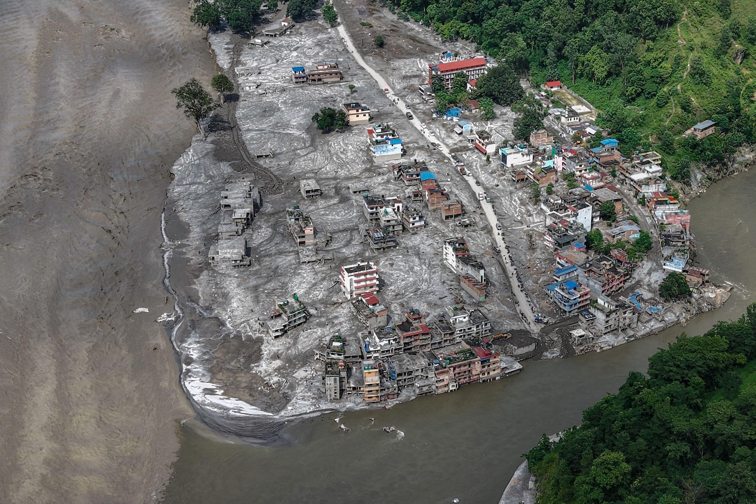
The flood destroyed vital cross-border infrastructure linking Nepal and China. Transport corridors between the two countries were severed after key bridges along the Rasuwa district border were washed away.
Additionally, several operational and under-construction run-of-the-river hydropower facilities along the Trishuli and Bhote Koshi rivers suffered severe structural damage, causing power outages across central Nepal and disrupting regional economic activity.
IMPACTED INFRASTRUCTURE SECTORS
┌───────────────────┬───────────────────────────────────────────┐
│ Sector            │ Primary Impact                            │
├───────────────────┼───────────────────────────────────────────┤
│ Energy            │ Hydropower plants clogged/damaged by mud  │
│ Transportation    │ Key border bridges & highways washed out  │
│ Humanitarian      │ >1,300 dead; thousands missing/displaced  │
│ Trade & Logistics │ Transboundary Nepal-China routes severed  │
└───────────────────┴───────────────────────────────────────────┘
Future Outlook & Systemic Vulnerabilities
The disaster underscores a major shift in natural hazard risks across High Mountain Asia. As temperatures continue to rise, hazards in steep mountain environments are increasingly interacting to create complex, compounding disasters.

MULTI-HAZARD CASCADE PHENOMENOLOGY
========================================================================
[1. Atmospheric Warming] ──> Accelerated melt & high-altitude heat spikes
[2. Cryospheric Thaw]    ──> Permafrost loss + Glacier retreat (~450m)
[3. Structural Failure]  ──> Bedrock collapse at high elevation (5,200m)
[4. Dynamic Transformation] ──> Rock/ice slurry formation & river blockage
[5. Cascade Outburst]    ──> Rapid-onset downstream inundation
========================================================================
Expanding Risk Footprint in the Hindu Kush Himalaya
According to long-term assessments by the International Centre for Integrated Mountain Development (ICIMOD), glaciers across the 3,500-kilometer Hindu Kush Himalaya region are losing mass at an unprecedented rate.
This retreat increases the occurrence of multiple high-altitude hazards:
- Glacial Lake Outburst Floods (GLOFs): Expanding glacial lakes contained by weak, unsolidated terminal moraines.
- Compound Bedrock-Ice Avalanches: Deep structural failures on steep mountain walls triggered by thermal destabilization and permafrost loss.
- Complex River Blockages: Secondary barrier lakes created when mass flows dam high-mountain narrow river channels.
These evolving hazards pose a direct threat to the 1.9 billion downstream residents who depend on the HKH water tower for domestic water, agriculture, and energy production.
HKH BREADTH & IMPACT ZONE
• Transboundary Extent: 3,500 km (spanning 8 nations)
• Downstream Population at Risk: ~1.9 Billion
• Core Structural Threat: Unstable high-altitude slopes & shifting river hydrology
Policy Imperatives and Mitigation Needs
To manage these compound risks, geoscientists and disaster management experts recommend three immediate priority actions:
- Integrated Transboundary Monitoring: Deploy real-time seismic monitoring, automated water-level sensors, and satellite radar imaging across borders to detect sudden slope movements and river blockages in remote alpine catchments.
- Dynamic Downstream Warning Systems: Install automated early-warning sirens and satellite-linked broadcast networks capable of alerting downstream towns within minutes of sudden river surges.
- Climate-Resilient Infrastructure Planning: Revise engineering standards for hydropower plants, bridges, and highways built along glacial river basins, taking into account high-sediment hyper-concentrated flows and sudden flood surges.
Without updated risk models and investment in alpine monitoring infrastructure, rapid cryospheric thaw will continue to transform high-mountain slopes into volatile hazard zones, putting vulnerable mountain communities at risk.