Executive Overview
In a significant move for British crown dependency waters, a visionary conservation proposal has been unveiled to dramatically enhance the environmental protections surrounding the island of Sark in the Channel Islands. Developed through a collaborative framework involving the island’s agriculture, environment, and sea fisheries committee, alongside the conservation charity the Blue Marine Foundation, local fishermen, and leading marine biologists, the initiative aims to safeguard approximately 50 square miles (128.8 square kilometers) of biologically rich sea.
This comprehensive strategic blueprint is designed to address a critical modern dilemma: how to effectively balance the urgent necessity of marine habitat restoration with the long-term economic and cultural viability of artisanal, low-impact coastal fishing. By establishing enhanced protective measures across nearly 50 square miles of pristine yet vulnerable marine ecosystem, Sark is positioning itself at the forefront of European island conservation.
The initiative moves beyond traditional, restrictive top-down conservation models. Instead, it relies on a stakeholder-driven approach that weaves together traditional ecological knowledge from local fishing communities with cutting-edge marine science. As global biodiversity faces unprecedented threats from climate change, overfishing, and habitat degradation, the Sark proposal offers a scalable blueprint for small island communities seeking to protect their natural heritage without sacrificing their maritime economies.
Detailed Chronology: From Grassroots Concern to Policy Formulation
The journey toward enhanced marine protection around Sark did not happen overnight; it represents the culmination of years of quiet observation, rising ecological concern, and meticulous diplomatic consensus-building among island stakeholders.
Phase One: Recognizing the Ecological Vulnerability (2018–2021)
Long before formal proposals reached committee desks, local fishermen and divers around Sark noticed subtle yet alarming shifts in the surrounding waters. Catches of certain prized species were becoming less predictable, and delicate benthic habitats—such as cold-water corals and fragile maerl beds—were showing signs of stress from localized pressures and modern, heavy gear use.
During this period, marine scientists began conducting preliminary surveys of the Channel Islands’ broader maritime zone. These studies underscored the unique ecological significance of Sark’s surrounding waters. Positioned within the swift-flowing tidal currents of the English Channel, the seabed around Sark acts as a biological crossroads, hosting an unusually high concentration of marine life, ranging from commercially vital fish stocks to rare invertebrate species.
Phase Two: Forging Strategic Partnerships (2022–2023)
Recognizing that local authorities alone might lack the resources to design a robust, scientifically backed management plan, Sark’s agricultural, environment, and sea fisheries committee initiated formal dialogues with the Blue Marine Foundation. Known for its pragmatic, collaborative approach to marine reserves across the UK and its overseas territories, the foundation brought essential technical expertise, mapping capabilities, and policy-drafting capacity to the table.
Crucially, the partnership was built on an inclusive foundation. Rather than imposing external regulations, the project organizers established a series of roundtables with Sark’s local fishing community. These sessions ensured that the people whose livelihoods depend on these waters had a direct hand in shaping the boundaries and rules of the prospective marine protected area (MPA).
Phase Three: Consensus and Proposal Launch (2024–Present)
By synthesizing years of biological data with the practical insights of local fishers, the committee and its partners finalized a cohesive spatial management plan. The proposal, which carves out approximately 50 square miles of sea for specialized stewardship, marks a transition from informal stewardship to formalized, legally backed marine spatial planning.
The announcement has garnered widespread interest from environmental regulators across the British Isles, setting the stage for legislative review and implementation phases that will test the resilience and adaptability of Sark’s governance structures.
Supporting Context & Metrics: The Ecological and Economic Significance of Sark’s Waters
To understand the true magnitude of the Sark proposal, one must examine the unique geography, ecology, and socioeconomic realities that define this corner of the Channel Islands.
The Ecological Canvas
Sark is the smallest of the four main Channel Islands, characterized by its dramatic cliffs, isolated bays, and a strict ban on motor cars that has long preserved its rustic, unpolluted charm. This terrestrial isolation is mirrored in its marine environment. The waters surrounding the island are exceptionally clear, nutrient-rich, and subjected to powerful tidal movements that drive high biological productivity.
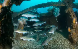
- Benthic Biodiversity: The seabed features complex rocky reefs, gravel beds, and sediment plains that serve as essential nursery grounds for commercial fish species such as bass, brill, and turbot.
- Carbon Sequestration: Like many shallow coastal waters rich in macroalgae and sedimentary habitats, the proposed conservation zone plays an unheralded role in capturing and storing blue carbon, helping mitigate global climate change at a local level.
- Endemic and Migratory Species: The area acts as a migratory corridor for marine mammals, seabirds, and pelagic fish, making its preservation a matter of international ecological responsibility.
The Socioeconomic Equation
Sark’s economy relies heavily on tourism, subsistence and small-scale commercial fishing, and the preservation of its pristine natural aesthetics. Unlike industrial fisheries that operate massive trawlers, Sark’s fishers typically employ static gear—such as pots, lines, and nets—that have a minimal carbon footprint and virtually zero destructive impact on the seabed.

The 50-square-mile protected area is specifically engineered not to penalize these sustainable operators. Instead, the framework seeks to exclude industrial, highly destructive mobile fishing gear (such as bottom trawlers and dredges) that can plow up centuries-old seabed ecosystems in minutes. By eliminating this heavy footprint, the proposal directly protects the long-term yields of local fishers, ensuring that the marine pantry remains stocked for generations to come.
Official Statements and Stakeholder Perspectives
The strength of the Sark proposal lies not merely in its geographic scope, but in the rare alignment of interests between conservationists, government bodies, and commercial harvesters.
The Conservation Voice: Freddie Watson
Speaking on behalf of the initiative, Freddie Watson, Channel Islands project manager at the Blue Marine Foundation, articulated the dual purpose of the framework. He emphasized that modern marine protection must be viewed not as a lock-and-key exclusion zone, but as a dynamic management tool for prosperity.
"Marine protection could help safeguard sensitive habitats while supporting sustainable fishing," Watson noted during the rollout of the initiative.
His perspective highlights a core philosophy of the Blue Marine Foundation: that environmental health and human economic security are inextricably linked. By buffering sensitive ecological zones against destructive practices, fishers are ultimately handed a secure, productive resource base rather than a depleted wasteland.
Local Fishermen and Committee Insights
Representatives from Sark’s agriculture, environment, and sea fisheries committee echoed this sentiment, pointing out that local stewardship is the only way to guarantee the survival of the island’s maritime traditions. For generations, Sark families have read the tides, winds, and seasonal migrations of the Channel waters. Incorporating this generational wisdom into the formal legal framework ensures that the regulations are both practical and enforceable.
Local fishermen who participated in the planning sessions expressed cautious optimism. Many view the proposed 50-square-mile zone as a necessary shield against outside industrial fleets that possess the capacity to sweep through traditional fishing grounds in a single season. By establishing clear territorial boundaries and protective rules, local operators can secure their place in the island’s economic future.
Future Outlook: Challenges, Implementation, and Global Significance
As the Sark proposal transitions from the drawing board to the legislative and operational arena, several key milestones and challenges lie ahead.
Regulatory Hurdles and Governance
Implementing a marine protected area of this scale requires careful navigation of local legislation, Crown dependency protocols, and international maritime boundaries. Sark’s unique constitutional status means its parliament (the Chief Pleas) must formally adopt and enact the regulations. Ensuring that the legal framework is airtight will be essential to prevent legal challenges from external commercial fishing lobbies who may view the restrictions with hostility.
Monitoring, Enforcement, and Adaptive Management
Designating a protected area on paper is only the first step; the true test of any marine conservation initiative lies in its enforcement. Moving forward, stakeholders will need to establish robust monitoring protocols. This could involve a combination of:
- Vessel Monitoring Systems (VMS): Utilizing satellite tracking to ensure unauthorized commercial vessels do not cross into restricted zones.
- Community-Led Surveillance: Empowering local fishers and marine wardens to report suspicious activity.
- Scientific Baseline Studies: Continuing ecological surveys to measure the recovery of fish stocks and benthic habitats over 5-, 10-, and 20-year intervals.
A Beacon for Island Communities
Beyond the immediate waters of the Channel Islands, the Sark initiative carries profound symbolic and practical value. Small island developing states and coastal communities across Europe and the wider world are grappling with the exact same paradox: how to protect marine biodiversity while preserving coastal livelihoods.
If Sark successfully implements this 50-square-mile protected area through genuine collaboration between scientists, conservationists, and local fishers, it will provide a living proof-of-concept. It will demonstrate that grassroots-driven, science-backed marine spatial planning is not an unattainable ideal, but a practical, highly effective roadmap for the future of our oceans.
As global leaders look toward ambitious international targets for ocean conservation—such as protecting 30% of the world’s oceans by 2030—it is often these small, committed communities leading the charge from the ground up. Sark’s bold step into marine stewardship proves that even the smallest islands can cast a very large, enduring shadow of positive change across the sea.