

Executive Overview
The planet’s climate system is undergoing a massive, highly visible shock. According to scientists tracking Pacific Ocean temperatures, the developing El Niño climate phenomenon has officially surpassed all previous historical benchmarks, cementing its status as the strongest on record. Daily sea surface temperatures in the critical central-eastern Pacific region reached an alarming 3.05°C above average on September 19, cleanly eclipsing the previous benchmark of 3.02°C set during the notoriously intense El Niño of 2015.
While certain long-term composite indices have yet to register peak historical thresholds, climatologists emphasize that this milestone is all but inevitable as the phenomenon continues to intensify toward its anticipated peak later in the year. The ripple effects of this oceanographic anomaly are already being felt across multiple continents. From catastrophic wildfires threatening millions in Indonesia and depressed monsoon rains in India to a historically delayed Atlantic hurricane season, the ongoing El Niño is radically disrupting traditional weather patterns.
Met Office forecasters and international meteorologists have spent months signaling that this event would be an unprecedented anomaly. Now, with the data confirming their projections ahead of schedule, governments, agricultural sectors, and emergency management agencies worldwide are bracing for widespread socioeconomic and environmental repercussions.
Detailed Chronology and Pacific Ocean Dynamics
To understand the severity of the current climate anomaly, one must examine the fundamental mechanics of the El Niño-Southern Oscillation (ENSO). El Niño is a naturally occurring, cyclical climate pattern that typically emerges every two to seven years, persisting for roughly 12 months. Under normal conditions, trade winds blow robustly from east to west across the tropical Pacific Ocean, pushing warm surface waters toward Asia and Australia while drawing up cooler, nutrient-rich deep water—a process known as upwelling—off the coast of South America.
However, during an El Niño phase, these trade winds weaken significantly or, in some cases, reverse direction entirely. This atmospheric shift allows massive pools of warm ocean water to surge eastward across the Pacific basin. As this immense body of heat spreads, thermal energy is released from the ocean surface directly into the atmosphere. This massive injection of heat alters global atmospheric circulation cells, permanently displacing jet streams and fundamentally altering precipitation and temperature baselines across the globe.
The chronology of the current event has alarmed atmospheric scientists due to its accelerated trajectory. While El Niño episodes typically build gradually throughout the mid-to-late calendar year, the 2026 event exhibited anomalous temperature surges as early as late spring, culminating in the record-shattering daily reading of 3.05°C above average on September 19. Because the cyclical phenomenon has not yet reached its seasonal peak—usually occurring in the late fourth quarter—meteorologists anticipate that surface temperatures will climb even higher, pushing Earth into uncharted climatic territory.
Supporting Context & Metrics: Measuring the Unprecedented
Quantifying the magnitude of an El Niño is complex, relying on various indices that measure temperature anomalies differently. The headline-grabbing records broken in September stem from raw, daily measurements of sea surface temperature compared directly against long-term historical baselines. This standard approach is traditionally reflected in the Oceanic Niño Index (ONI).
Yet, leading meteorological institutions—including agencies in the United States and Australia—also heavily rely on an alternative metric: the Relative Oceanic Niño Index (RONI). Unlike standard absolute metrics, the RONI measures how warm the central-eastern Pacific is relative to the rest of the tropical oceans. This ingenious metric effectively filters out the relentless, long-term background warming caused by anthropogenic climate change.
According to the RONI index, the current El Niño has not yet officially broken all relative records, though scientists note that this cross-over is rapidly approaching. The juxtaposition of these metrics highlights a sobering reality: modern El Niño events are occurring against a baseline of globally heated oceans, supercharging their intensity and exacerbating their downstream impacts.

Professor Adam Scaife, Head of Long Range Prediction at the UK Met Office, underscored the gravity of the situation:
"We have been signalling for months that the developing El Niño will be an unprecedented event. The fact that it has already exceeded previous records—with several weeks to go before it peaks later this year—shows the enormity of this El Niño."
Global Impacts: Droughts, Floods, and Disrupted Seasons
Every El Niño cycle possesses unique characteristics, meaning that while the phenomenon guarantees disruptions, the exact geographic distribution and severity of its local impacts can vary. Nevertheless, the extraordinary magnitude of the 2026 event is translating into severe, textbook disruptions across multiple hemispheres.
Asia and the Indian Monsoon
In India, El Niño years notoriously correlate with suppressed monsoon rainfall. Official statistics from the India Meteorological Department confirm this trend vividly, revealing that the southwest monsoon brought 15% less rain than normal through September 22. This rainfall deficit poses immediate challenges to agricultural output, groundwater replenishment, and rural economies dependent on seasonal precipitation for crop viability.
The Atlantic Hurricane Quiet Zone
Conversely, the atmospheric wind shears generated by an active El Niño typically suppress tropical cyclone formation in the Atlantic basin. This year, that suppression has reached historic extremes. As of late September, zero Atlantic hurricanes have formed, setting a modern record for the latest date without a named hurricane since satellite observation of marine weather began. While this provides a temporary reprieve for vulnerable Caribbean and Gulf Coast communities, it reflects profound shifts in high-altitude atmospheric dynamics.
Wildfires and Extreme Heat in Southeast Asia and South America
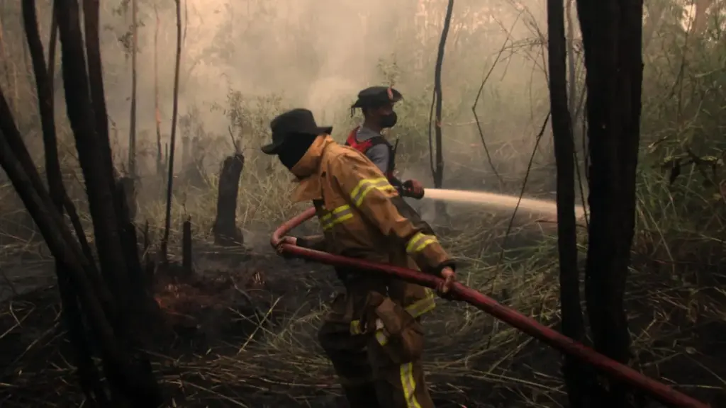
The humanitarian toll is already manifesting acutely in regions vulnerable to drought. In Indonesia, the health ministry reports that wildfires fueled by the dry conditions associated with El Niño are directly affecting approximately 12.5 million people. Thick, toxic haze has blanketed rural and urban sectors, threatening public health and straining local firefighting resources. Similar elevated threats of prolonged drought and devastating bushfires are currently impacting agricultural sectors in Australia, Brazil, and parts of Central America.
Conversely, equatorial coastal regions—particularly Ecuador, Peru, and parts of the southern United States—are facing heightened risks of catastrophic flash flooding and intense coastal storms as warm Pacific waters dump massive moisture loads onto adjacent landmasses.
Official Statements and Risk Analysis
The cascading effects of the 2026 El Niño extend far beyond local weather anomalies, threatening global supply chains, international food security, and macroeconomic stability. Agricultural commodities, from coffee and cocoa to wheat and palm oil, are highly sensitive to the precipitation deficits and thermal spikes characteristic of El Niño years.
International risk analysts and climate scientists are currently locked in intensive modeling sessions to determine whether the impacts of this event will scale proportionally with its record-breaking magnitude. Professor Scaife noted the cautious approach within the scientific community:

"Scientists are still assessing whether the impacts will be in proportion to its magnitude, but we are already seeing expected effects worldwide."
Emergency preparedness organizations and international relief agencies are scaling up operations in anticipation of prolonged droughts in the Southern Hemisphere and severe storm surges along western American coastlines. Governments are being urged to integrate these probabilistic climate forecasts into national food reserves and energy grid management strategies to mitigate potential supply shocks.
Will There Be an Impact on UK Weather?
While the United Kingdom lies thousands of miles away from the tropical Pacific Ocean, the atmospheric teleconnections linking global weather systems mean that El Niño’s influence inevitably reaches northwest Europe. However, these linkages are notoriously complex and less direct than those observed in regions bordering the Pacific.
Historically, strong El Niño phases during late autumn and early winter correlate with an increased frequency of wet, stormy, and unsettled conditions across the UK and northern Europe. A seasonal forecast released by the Met Office explicitly flagged these patterns, noting strong "signals for increased rainfall and storminess in autumn here in the UK," with the risk intensifying significantly as the calendar turns toward November and December.
The historical precedent for such conditions is stark. The winter of 2015/2016—which coincided with the previous record-holding El Niño—unleashed a relentless procession of deep low-pressure systems that delivered the most extreme, widespread flooding on record to parts of the UK.
In addition to enhanced storm activity, El Niño has occasionally been linked to late-winter cold snaps and high-pressure blocking patterns. Yet, climatologists emphasize that this correlation is weak and historically inconsistent. For instance, the infamous "Big Freeze" of the 2009/2010 winter—one of the coldest in three decades—occurred during an El Niño year. Conversely, the winter of 2006/2007 also featured an active El Niño but went down in meteorological archives as unseasonably warm.
Future Outlook
As the unprecedented 2026 El Niño approaches its meteorological zenith toward the end of the year, the international scientific community remains on high alert. Satellites, ocean buoys, and supercomputer climate models will continue to track every fluctuation in sea surface temperatures and atmospheric pressure gradients.
The implications of this event extend beyond immediate weather disruptions; they serve as a critical stress test for global climate resilience. As global temperatures continue to rise against a backdrop of long-term climate change, understanding how hyper-charged natural oscillations like El Niño interact with a warmer world will be vital for protecting human lives, safeguarding global food supplies, and preparing societies for an increasingly volatile meteorological future.



