Executive Overview
Across the remote expanses of the Arctic, a dramatic transformation is quietly reshaping the landscape. Millions of lakes, cradled for millennia by permanently frozen ground known as permafrost, serve as ecological linchpins for the region’s specialized wildlife and indigenous communities. Today, however, these vital bodies of water are undergoing a rapid and erratic metamorphosis. Driven by accelerated global heating, the permafrost beneath them is thawing at an unprecedented rate. This subsurface collapse triggers a dual crisis: the sudden, ghost-like disappearance of established lakes as they drain through newly carved subterranean channels, and the birth of unstable new pools where the ground has subsided.
To track this unfolding ecological emergency, an international team of researchers has launched LostLakes, a groundbreaking interactive mapping platform. Accessible to the public and scientific community alike, LostLakes monitors the near real-time dynamics of approximately 4 million Arctic lakes, tracing their evolution back to 2016. By observing how these bodies of water expand, contract, or vanish entirely, scientists gain a critical window into the hidden state of the underlying permafrost.
Beyond tracking surface hydrology, the degradation of permafrost carries profound global implications. Trapped within these frozen subterranean layers are massive reservoirs of ancient carbon, accumulated over hundreds of thousands of years from decayed plants, animals, and microbes. As the permafrost thaws, this organic matter decomposes and releases greenhouse gases into the atmosphere, creating a perilous feedback loop that accelerates global climate change.
Furthermore, the physical shifting of the terrain poses immediate risks to Arctic infrastructure and local populations. Understanding lake dynamics through tools like LostLakes is no longer merely an academic exercise; it is an urgent imperative for predicting landscape stability, safeguarding communities, and charting the future of the Earth’s most rapidly warming region.
Detailed Chronology: From Ancient Ice to Modern Satellite Surveillance
To comprehend the fragility of the modern Arctic, one must look deep into the geological timeline of the region. The story of Arctic lakes and permafrost is an ancient one, yet the pace of change has shifted dramatically over the past century.
The Genesis of Arctic Hydrology (12,000 Years Ago to Mid-20th Century)
The vast majority of Arctic lakes originated at the close of the last Ice Age, roughly 12,000 years ago. As retreating glaciers and shifting climates altered northern latitudes, massive sheets of ice embedded in the soil began to adjust. Over millennia, organic material accumulated in the cold, waterlogged soils, becoming freeze-locked in ice-rich permafrost.
When regional ground temperatures occasionally flickered above the freezing point (0°Celsius or 32°Fahrenheit), localized thawing occurred. The ground would sink, creating modest depressions that collected rain and meltwater. Over centuries, these primitive pools matured into stable, sprawling lakes. This natural lifecycle—slow formation, decades or centuries of relative stability, and eventual ecological succession—was the baseline for Arctic environments until the mid-20th century. Even in recent memory, scientists documented the birth of new thermokarst ponds in places like western Alaska during the mid-1900s, proving that the landscape was always dynamic, albeit at a measured, predictable pace.
The Acceleration of the Anthropocene (Late 20th Century to 2016)
As human-induced greenhouse gas emissions warmed the planet, the Arctic began to bear the brunt of the crisis, heating up at a rate two to four times faster than the global average. This disproportionate warming fundamentally disrupted the delicate thermal equilibrium of the permafrost. Subsurface ice began to melt on a massive scale, causing widespread ground subsidence.
By the early 2000s, scientists recognized that Arctic lakes were beginning to behave erratically. Traditional fieldwork—which involved arduous expeditions to drill into remote permafrost and measure internal temperatures—proved entirely inadequate for capturing the sheer scale and speed of these changes. The landscape was transforming faster than researchers could map it on foot.
The Turning Point: The Summer of 2018
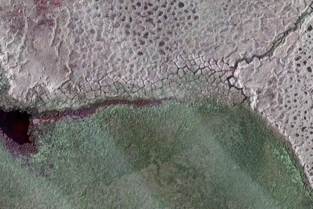
A stark manifestation of this crisis occurred in the summer of 2018 across northwestern Alaska. Following an unusually warm winter, researchers noted a shocking hydrological anomaly: nearly 200 lakes shrank or completely emptied within a single season. The heat had thawed the surrounding permafrost to such a degree that newly opened channels allowed entire lakes to drain away in a matter of weeks, leaving behind barren scars of cracked mud and eroded ice-wedge polygons.
The Birth of LostLakes (Present Day)
Recognizing the urgent need for continuous, large-scale observation, remote sensing scientists—including experts at Germany’s prestigious Alfred Wegener Institute—turned to advanced satellite imagery and computing. Synthesizing years of satellite data, the team developed LostLakes, an open-access interactive database launched to provide unprecedented visibility into the shifting Arctic surface. By tracking roughly 4 million lakes in near real time and archiving changes dating back to 2016, the platform bridges the gap between complex remote sensing science and practical, real-world application.
Supporting Context & Metrics: The Mechanics of Thaw and the Carbon Threat
The disappearance and formation of Arctic lakes are symptoms of a much larger, invisible geological crisis occurring beneath the surface. To understand why a vanishing lake matters, one must examine the complex physics of permafrost and its role in the global climate system.
The Anatomy of Permafrost and Thermokarst Lakes
Permafrost is defined as ground—whether rock, soil, or sediment—that remains at or below 0°C for at least two consecutive years. Much of the Arctic sits atop "ice-rich" permafrost, which contains massive lenses and wedges of ancient solid ice.
When rising atmospheric temperatures penetrate the soil, this buried ice melts. As the ice turns to water, the volume of the ground decreases, causing the surface to collapse. This subsidence creates depressions known as thermokarst depressions. When water fills these basins, thermokarst lakes are born.
However, this process is a double-edged sword. While the initial thaw creates a lake, continued warming destabilizes the earthen walls and permafrost barriers holding the water in place. Eventually, thermal erosion cuts channels through the soil, allowing the lake water to breach its banks and drain catastrophically into nearby river systems or the ocean.
The Global Carbon Bomb
The most alarming aspect of permafrost degradation extends far beyond localized landscape deformation. For hundreds of thousands of years, the frozen soils of the Arctic have acted as Earth’s premier deep-freeze organic vault. As plants, animals, and microscopic organisms died, they were trapped in the permafrost before they could fully decay.
Scientists estimate that Arctic permafrost holds twice as much carbon as is currently present in Earth’s atmosphere. When the permafrost thaws, microbes awaken and begin breaking down this ancient organic matter. This process releases carbon dioxide and methane—potent greenhouse gases—directly into the atmosphere.

"Once the permafrost thaws, some of this carbon, which was freeze-locked there for thousands of years, can go to the atmosphere and further fuel the warming, which may lead to a faster permafrost thaw," explains Ingmar Nitze, a leading remote sensing researcher at the Alfred Wegener Institute.
This creates a dangerous positive feedback loop: global emissions warm the Arctic; the warming thaws the permafrost; the permafrost releases ancient carbon; and that extra carbon accelerates global warming even further.
The Challenge of Direct Monitoring
Directly monitoring permafrost has historically been an immense logistical hurdle. Because permafrost is hidden beneath layers of soil, tundra vegetation, and snow, scientists traditionally had to travel to remote locations, hammer heavy metal tubes into the ground, and install thermal sensors to measure subsurface temperatures point-by-point.
While these ground-truthing methods remain essential for precise local data, they cannot cover the millions of square miles of the circumpolar Arctic. This is where surface hydrology becomes an invaluable proxy. Because lakes respond directly to the thawing and shifting of the permafrost beneath them, tracking the lakes via satellite provides a reliable, macro-level indicator of underground permafrost health without requiring scientists to dig up the tundra.
Official Statements & Expert Insights
The creation and deployment of the LostLakes platform mark a significant milestone in climate transparency and collaborative research. Experts behind the initiative emphasize the platform’s democratic design and its critical utility for both specialized researchers and the general public.
Democratizing Science for Experts and Non-Experts
For too long, high-resolution remote sensing data regarding the cryosphere has been locked behind expensive software or complex academic jargon. The Alfred Wegener Institute sought to dismantle these barriers with LostLakes.
"LostLakes is completely free and designed to be used by experts and non-experts at the same time," Ingmar Nitze stated in an interview with Mongabay.
By providing an intuitive, user-friendly interface, the platform empowers educators, policymakers, indigenous leaders, and curious citizens to visualize environmental change in their regions of interest. Whether a user wants to check a specific watershed in Siberia, northern Canada, or Alaska, the tool offers transparent, accessible insights into ecological shifts.
Differentiating Natural Dynamics from Accelerated Degradation
Scientists are quick to point out that lake formation and drainage are not inherently unnatural. The Arctic has always been a dynamic, shifting environment where lakes naturally appear and disappear over long geological spans. However, researchers stress that the rate and scale of the changes observed today are unprecedented.
"Arctic lake formation and drainage is a natural process," Nitze noted. "However, the number of lakes and speed at which they’re changing over time can indicate permafrost degradation."
When hundreds of lakes drain simultaneously following a single anomalously warm winter—as witnessed in northwestern Alaska—it signals that the system has been pushed far beyond its historical variance, moving into a state of rapid, unmitigated collapse.
Future Outlook: Infrastructure Risks and the Road Ahead
As the Arctic continues to warm at rates surpassing the rest of the planet, the implications of disappearing lakes and thawing permafrost extend far beyond ecological conservation. They pose a direct threat to human habitation, industrial planning, and global climate stability.
Implications for Arctic Communities and Infrastructure
The degradation of ice-rich permafrost transforms solid ground into unstable, treacherous terrain. For indigenous communities and industrial planners operating in the North, understanding where permafrost is rapidly thawing is a matter of safety and economic survival.
Regions characterized by high ice content in the permafrost are structurally compromised; when the ice melts, foundations shift, roads buckle, pipelines fracture, and buildings risk structural collapse. Conversely, areas with lower ground ice content may offer relatively stable ground for future community development and infrastructure projects.
By integrating tools like LostLakes into regional planning, local governments and civil engineers can better assess landscape stability, avoiding hazardous construction zones and mitigating costly infrastructural damage.
The Imperative of Continuous Global Monitoring
The launch of LostLakes represents a crucial leap forward, but it is only one piece of a much larger scientific puzzle. As artificial intelligence and machine learning models become more sophisticated, researchers plan to refine satellite data processing to capture even finer details of hydrological and permafrost changes.
Ultimately, platforms like LostLakes serve as an urgent warning system. They translate the invisible, subterranean melt of the Arctic into visible, undeniable evidence of a planet in transition. As these lakes vanish into the tundra, they carry away the ancient secrets of the ice—and leave behind a stark reminder of the escalating consequences of global climate change.