By the Environmental and Marine Conservation Desk
Published in Collaboration with Global Marine Research Initiatives
Executive Overview
For decades, the journey of a young sea turtle has been one of the ocean’s most closely guarded secrets. After hatching on sandy beaches and frantically crawling toward the surf, juvenile marine turtles seemingly vanish into the vast, blue expanse of the open ocean. For marine biologists, this mysterious phase—aptly termed the "lost years"—has long represented a critical gap in conservation science. Understanding where these vulnerable creatures go, how they navigate, and what threats they face during this formative period is vital for their survival.
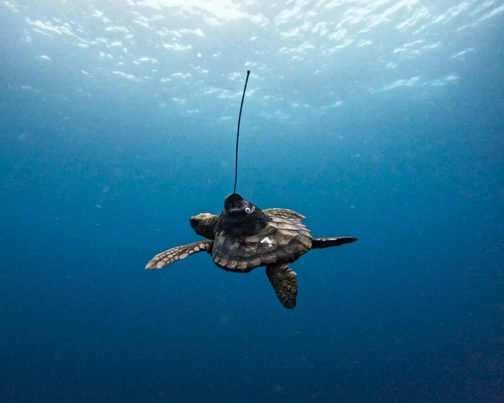
Now, a groundbreaking collaborative initiative is pulling back the curtain on this secretive life stage. By outfitting rehabilitated juvenile loggerhead turtles—such as individuals affectionately named Tolkien and Mpho—with miniature, high-tech satellite tags, scientists are finally tracking their epic post-release odysseys. This multi-institutional endeavor brings together the renowned Two Oceans Aquarium Turtle Conservation Centre, the marine research and conservation non-profit Upwell Turtles, and Sylvia Earle’s ocean advocacy foundation, Mission Blue.
Through an interactive digital StoryMap, researchers are sharing real-time tracking data that reveals how these young survivors navigate South Africa’s officially designated "Hope Spots" and transition into the treacherous currents of the open ocean. More than just a heartwarming tale of rehabilitation and return, this project serves as a critical investigative tool. The telemetry data is actively shedding light on critical marine habitats, identifying high-risk zones where human activity intersects with turtle migration corridors, and providing the empirical foundation needed to advocate for stronger, legally binding ocean protections worldwide.
Detailed Chronology: From Rescue to Open Ocean
To truly appreciate the significance of the satellite tracking data, one must understand the arduous journey these juvenile loggerheads undertake just to reach the starting line of their migratory lives.
Phase 1: Rescue and Stabilization
The life of a rehabilitated sea turtle rarely begins under favorable circumstances. Along the rugged and often unforgiving coastlines of South Africa, young loggerheads frequently find themselves stranded due to severe storms, entanglement in marine debris, boat strikes, or acute hypothermic stunning caused by unexpected drops in water temperature.
When these distressed reptiles are brought to the Two Oceans Aquarium Turtle Conservation Centre, they enter a rigorous, intensive medical pipeline. Veterinarians and specialized aquarists treat severe dehydration, respiratory infections, shell damage, and buoyancy disorders. For months—and sometimes over a year—these turtles receive round-the-clock care, specialized nutrition, and physical rehabilitation designed to restore their natural swimming and diving capabilities.
Phase 2: The Decision to Release
Rehabilitation is only half the battle; preparing a wild animal for re-entry into a dynamic and dangerous marine environment requires immense precision. Animals like Tolkien and Mpho are evaluated not just for physical health, but for behavioral readiness. Do they forage aggressively? Can they dive to appropriate depths? Are they strong enough to contend with powerful coastal currents?
Once cleared by veterinary staff, the release process is carefully planned. These releases are not merely sentimental send-offs; they are meticulously orchestrated scientific deployments. Prior to release, each juvenile loggerhead is fitted with a specialized, low-profile satellite transmitter attached to its carapace using non-toxic, marine-grade adhesives. These transmitters are engineered to minimize drag and detach naturally as the turtle grows, ensuring the animal’s safety and long-term comfort while providing researchers with an invaluable continuous feed of geographic coordinates.
Phase 3: Navigating the Hope Spots
Upon release into South African waters, the tracking data immediately begins to tell a compelling story. The newly freed juveniles do not simply drift aimlessly; they interact dynamically with some of the most ecologically rich and sensitive marine environments on the planet.
The tracking initiative specifically highlights movements through South Africa’s Hope Spots—special areas scientifically identified as critical to the health of the ocean. As Tolkien, Mpho, and their peers navigate these protected waters, satellite feeds record their utilization of coastal shelves, upwelling zones, and current lines. During this phase, researchers observe how the turtles utilize natural flotsam and thermal fronts for shelter and feeding, mimicking the natural behaviors that define the elusive "lost years."
Phase 4: Transition into the Open Ocean
As the juveniles grow stronger and their navigational instincts fully engage, the telemetry data captures their daring push away from the safety of the continental shelf and into the high seas. This is the crux of the "lost years" mystery. By monitoring these pathways, scientists can map the exact oceanic high-ways—such as the Agulhas Current system—that sweep the turtles into distant pelagic zones. Every ping sent from a satellite tag demystifies another mile of the open ocean, turning a scientific black box into a transparent, data-driven map of survival.
Supporting Context & Metrics: Decoding the "Lost Years"
The term "lost years" is not merely poetic; it reflects a profound historical deficiency in marine biology. For generations, marine scientists could study sea turtles when they nested on beaches or when they hauled out as sub-adults in nearshore feeding grounds, but the developmental years spent in the open ocean remained virtually unobserved.
The Technological Leap: Miniaturized Satellite Telemetry
Historically, tracking juvenile sea turtles was nearly impossible because traditional satellite tags were simply too large and heavy for small animals. Putting a standard transmitter on a juvenile loggerhead would compromise its hydrodynamics, exhaust its energy, and impede its ability to dive or evade predators.
The advent of ultra-lightweight, miniaturized satellite tags has completely revolutionized the field. These state-of-the-art devices transmit precise GPS coordinates to orbiting Argos satellite networks whenever the turtle surfaces to breathe. This continuous stream of telemetry yields critical metrics, including:
- Travel Speeds: Calculating how fast juveniles move against or with major oceanic currents.
- Habitat Utilization: Identifying depth preferences, temperature thresholds, and geographic boundaries favored by the species during development.
- Mortality and Dispersal Rates: Differentiating between normal migratory behavior, stationary resting periods, and sudden, anomalous stops that could indicate predation or capture.
The Ecological Significance of Hope Spots
The collaboration heavily emphasizes South Africa’s Hope Spots—conceptually pioneered by Mission Blue. These areas act as marine equivalents of national parks, safeguarding biodiversity hotspots that are essential for maintaining ocean resilience. By mapping the telemetry tracks of rehabilitated loggerheads against these designated zones, scientists can evaluate whether current spatial management strategies are effectively protecting migratory marine species.
The data often reveals a sobering truth: while Hope Spots offer robust localized protection, highly migratory species like sea turtles routinely cross international boundaries and enter unprotected high seas, exposing them to industrial longline fishing, plastic pollution, and maritime traffic.
Official Statements and Expert Perspectives
The partnership between the Two Oceans Aquarium Turtle Conservation Centre, Upwell Turtles, and Mission Blue represents a synergistic approach to modern marine conservation, blending grassroots rehabilitation with high-level geospatial analysis.
Dr. Sylvia Earle, legendary oceanographer and founder of Mission Blue, has repeatedly emphasized the interconnectedness of global marine ecosystems and the unique role that sea turtles play as ecosystem architects. Speaking on the importance of collaborative tracking initiatives, project advocates note that understanding individual journeys is the key to unlocking systemic change.
"We cannot protect what we do not understand. For too long, the early life stages of sea turtles have been shrouded in mystery, leaving massive blind spots in our conservation frameworks. By harnessing the power of satellite telemetry and digital storytelling, we are not just following individual turtles like Tolkien and Mpho; we are reading the pulse of the ocean itself. This data gives us the undeniable evidence we need to urge governments and international bodies to establish meaningful, connected sanctuaries across marine highways."
— Excerpts from Project Conservation Scientists
Furthermore, the animal care teams at the Two Oceans Aquarium emphasize the emotional and educational value of these programs. Rehabilitation is intensive, requiring specialized veterinary skills and deep dedication. Knowing that these rehabilitated animals go on to contribute vital scientific data transforms individual rescues into major milestones for global biodiversity conservation.
Future Outlook: Protecting the Open Ocean for Tomorrow
As climate change, industrial overfishing, and plastic pollution continue to exert unprecedented pressures on marine ecosystems, the insights gained from tracking Tolkien, Mpho, and other juvenile loggerheads have never been more urgent.
Bridging Science and Public Engagement
One of the most innovative aspects of this initiative is its accessibility. Recognizing that scientific data can sometimes remain trapped in academic journals, the collaborating organizations have transformed complex telemetry datasets into an engaging, publicly accessible ArcGIS StoryMap. By visiting storymaps.arcgis.com, students, educators, policymakers, and ocean enthusiasts from around the globe can trace the live paths of these turtles, fostering a deeper personal connection to marine conservation.
Policy Implications and Next Steps
Looking ahead, the long-term goal of this telemetry project extends far beyond mapping individual migrations. The empirical data collected by Upwell Turtles and the Two Oceans Aquarium is designed to directly inform international marine policy. Specifically, researchers aim to:
- Expand Marine Protected Areas (MPAs): Use migration corridors identified by satellite tags to advocate for the expansion and strict enforcement of protected zones along oceanic highways.
- Mitigate Bycatch Risks: Collaborate with commercial fisheries to modify gear types and seasonal operations in high-density juvenile turtle zones.
- Enhance Climate Resilience: Monitor how shifting ocean temperatures and changing current patterns influence migratory routes, helping conservationists anticipate future threats to sea turtle populations.
The journeys of Tolkien and Mpho remind us of the incredible resilience of marine life when given a second chance through human intervention. Yet, their ongoing travels in the wild deliver an even more powerful message: true conservation requires us to look beyond the coastline and commit to protecting the vast, interconnected open ocean that sustains us all.
To follow the ongoing journeys of these remarkable young loggerheads and explore the interactive maps detailing their migration across South Africa’s Hope Spots and into the open ocean, visit the official StoryMap at storymaps.arcgis.com.