

Executive Overview
In the peak of the European summer, a quiet county in south Wales found itself listed alongside some of the most volatile ecological disaster zones on the planet. According to alarming data released by the European Union’s Copernicus earth observation programme and highlighted by the children’s charity Save the Children, Torfaen recorded wildfire carbon emissions per square kilometre in July that placed it among the highest in the world.
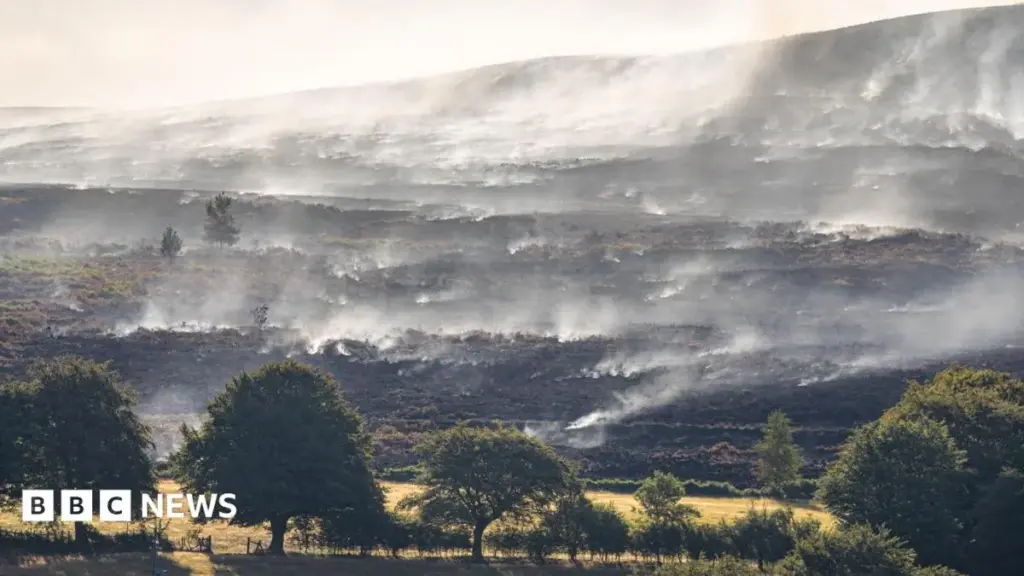
The distinction was driven by a massive, weeks-long blaze on the slopes above Blaenavon—a landscape more typically celebrated for its rich industrial heritage than as a frontline of the global climate crisis. Described by emergency responders as one of the largest and most challenging fires to hit south Wales in recent memory, the inferno scorched an area equivalent to roughly 300 football pitches. The smoke blanketed the region, drifted tens of miles away into the Welsh capital of Cardiff, and sparked a major incident that ultimately necessitated military intervention.
While the flames have long been extinguished, the political, environmental, and public health fallout is only beginning to unfold. Local authorities, health officials, and environmental advocates are grappling with the long-term consequences of an event that exposed systemic vulnerabilities in regional emergency preparedness and thrust the invisible health toll of particulate pollution into sharp relief. This report examines the chronology of the disaster, the startling metrics that caught international agencies’ attention, the friction between local government and monitoring bodies, and the looming questions regarding public health in an era of intensifying climate disruption.
Detailed Chronology: Anatomy of a Mega-Blaze
Ignition and the Escalation on Mynydd Garnclochdy
The crisis began when a spark ignited dry vegetation on Mynydd Garnclochdy, a sweeping upland area situated between Abersychan and Blaenavon within the historic county borough of Torfaen. Under the baking conditions of a July heatwave, the fire found ample fuel in parched gorse, heather, and peat soils.
Within hours, the blaze spiraled out of control. Fanned by shifting winds, the fire tore across the terrain, generating dense plumes of smoke that quickly engulfed the surrounding valleys. The sheer scale of the fire overwhelmed initial localized response efforts. Residents across Torfaen and neighboring boroughs reported choking air, while the distinct, acrid smell of burning moorland drifted nearly 30 miles (48 km) south into Cardiff.
The Declaration of a Major Incident
As July progressed, the fire on Mynydd Garnclochdy did not burn in isolation. It coincided with a wave of concurrent wildfires across south Wales, stretching fire and rescue services to a breaking point. The compounding crises forced local authorities and emergency planners to declare a major incident.
The designation unlocked additional emergency powers and resources, but the unrelenting nature of the blazes demanded extraordinary measures. The situation deteriorated to the point where regional commanders required assistance from the British military to provide logistical support, tactical oversight, and manpower on the ground to combat the relentless walls of fire.
Lingering Hazards: Weeks of Smolder
Even after the primary flames were beaten back, the threat did not vanish. Peat-heavy soils and deep-seated root systems continued to smolder underground long after the surface fires were declared under control. Local representatives noted that the atmospheric conditions remained perilous weeks after the initial ignition.
Blaenavon Councillor Janet Jones highlighted that the smoke hazard peaked significantly around 13 August—approximately three weeks after the fire first broke out. Trapped by atmospheric inversions common to the valley geography, the particulate-laden air lingered stubbornly over residential areas, transforming a landscape disaster into an ongoing environmental health hazard for the communities nestled below the ridgelines.
Supporting Context & Metrics: A Global Scale of Destruction
The Copernicus Data and International Comparisons
The true magnitude of Torfaen’s July wildfire emissions only came to light through the sophisticated satellite monitoring capabilities of the European Union’s Copernicus Atmosphere Monitoring Service (CAMS). The CAMS platform tracks global air pollution, greenhouse gas releases, and atmospheric composition through a combination of satellite observations and numerical models.
When analysts cross-referenced the global wildfire emissions for July, Torfaen’s emissions per square kilometre registered at an astonishingly high level. The Welsh county found itself ranked alongside heavyweights of global environmental devastation:
- Malanje, Angola: A region routinely subjected to extensive agricultural and savanna burning.
- Ávila, Spain: The site of severe Mediterranean forest fires driven by intense continental heatwaves.
- Annaba, Algeria: A Mediterranean basin zone vulnerable to extreme seasonal brushfires.
To place Torfaen on a comparative emissions league table with these expansive geographical areas underscores the density and intensity of the carbon released relative to the county’s compact landmass. CAMS officials characterized the emissions levels recorded in Torfaen as "extremely unusual" for the British Isles, signaling a sharp departure from historical baselines.
The Localized Impact: 300 Pitches of Destruction
Spatially, the primary blaze consumed approximately 300 football pitches of upland habitat. This destruction of carbon sinks—ecosystems that naturally absorb and store carbon dioxide—creates a double-edged sword for regional climate targets. Not only did the combustion instantly release vast quantities of greenhouse gases into the atmosphere, but the loss of vegetation and soil integrity severely diminishes the land’s capacity to sequester carbon in the future. Furthermore, the incineration of peat deposits releases ancient carbon stores that can take millennia to accumulate.
Official Statements and Institutional Friction
Save the Children’s Warning on Vulnerable Populations
The integration of satellite data with public health advocacy came from Save the Children, which voiced deep alarm over the implications of particulate pollution on youth development. Melanie Simmonds, Head of Save the Children Wales, issued a stark assessment of the crisis:
"In Wales and across the world, children are breathing in smoke from wildfires, coping with extreme heat and losing the freedom to play outdoors because the air is no longer safe. These conditions are not only frightening—they carry serious health consequences for children whose bodies and lungs are still developing."
The charity emphasized that particulate matter (PM2.5 and PM10) penetrates deep into the respiratory tract and enters the bloodstream. For children, whose respiratory systems are still forming and who inhale more air per pound of body weight than adults, exposure to heavy wildfire smoke can permanently impair lung function, trigger asthma attacks, and cause long-term cardiovascular vulnerabilities.
Torfaen Council’s Position: Skepticism and Methodological Questions
The response from local government highlighted a disconnect between international satellite tracking agencies and municipal monitoring infrastructure. Torfaen Council stated that it was entirely unaware of the EU-derived research prior to media inquiries and questioned the underlying methodology.
A council spokesperson remarked that "it is not clear what data or evidence was used in the assessment to arrive at the reported conclusion."
However, the council acknowledged the physical reality of the situation, noting that it "recognises that prolonged wildfire incidents have the potential to adversely affect local air quality, particularly through increased levels of smoke and particulate matter."
Regarding how air quality is tracked, the council explained that it continuously monitors atmospheric conditions via a dedicated monitoring station located in Croesyceiliog, Cwmbran. While conceding that "elevated particulate concentrations have been observed during the wildfire period," the local authority defended its monitoring limitations by pointing out that the station is designed to measure general background air quality across the broader area rather than capturing hyper-local, micro-climatic spikes occurring immediately adjacent to active fire zones in the northern uplands of the county.
Future Outlook: Public Health Horizon and Climate Preparedness
The Delayed Medical Toll
While acute injuries and burns were largely avoided during the Blaenavon fire, the insidious nature of wildfire smoke lies in its delayed health impacts. Medical professionals and local leaders are casting a wary eye toward the upcoming autumn and winter seasons.
Councillor Janet Jones noted that while she consulted with local general practice surgeries shortly after the peak smoke events and found no immediate surge in respiratory complaints, she cautioned that this baseline "could change in the months ahead."
Medical literature frequently correlates chronic low-level particulate exposure with delayed presentations of chronic bronchitis, exacerbations of chronic obstructive pulmonary disease (COPD), emphysema flare-ups, and cardiovascular incidents weeks or months after the initial exposure event has passed. Health boards across south Wales are bracing for a potential influx of vulnerable patients as seasonal weather shifts trap pollutants closer to the ground.
Policy Implications and Adaptation Strategies
The inclusion of a Welsh county in a global league table of high-intensity wildfire emissions serves as a watershed moment for emergency planning in the United Kingdom. Historically, catastrophic mega-fires have been viewed as problems exclusive to Mediterranean Europe, California, Australia, or the Siberian taiga. The events in Torfaen demonstrate that the British Isles are not immune to the compounding effects of climate change, prolonged droughts, and elevated fuel loads in upland areas.
Moving forward, local authorities, Natural Resources Wales, and the fire and rescue services face profound strategic questions:
- Enhanced Early Warning Systems: Bridging the gap between satellite observation platforms like Copernicus and local municipal response teams to ensure rapid deployment before fires breach containment thresholds.
- Peatland Restoration: Investing heavily in the restoration of degraded Welsh peatlands, which act as natural fire retardants when saturated and healthy, but become highly combustible powder kegs when drained or eroded.
- Targeted Air Quality Monitoring: Upgrading municipal monitoring capabilities to deploy mobile, hyper-local particulate sensors directly into valley communities during smoke events, moving beyond generalized background readings.
- Public Health Protocols: Establishing robust communication channels to advise schools, elderly care facilities, and vulnerable individuals on shelter-in-place strategies and air filtration measures during prolonged smoke episodes.
As global temperatures continue to climb, the smoke that choked the Blaenavon ridgeline may no longer be an isolated anomaly. For Torfaen and the wider Welsh landscape, the challenge ahead lies in transforming this stark international warning into a catalyst for proactive climate adaptation and public health resilience.



