Executive Overview
For decades, the early life stages of sea turtles have remained one of marine biology’s most enduring enigmas. Once hatchlings scramble from their nesting beaches and slip into the surf, they seemingly vanish into the vast, turbulent expanse of the open ocean. These enigmatic developmental phases—frequently referred to by scientists as the "lost years"—have long stymied conservation efforts, leaving researchers in the dark regarding the precise pelagic pathways, foraging habitats, and migratory corridors utilized by juvenile populations.
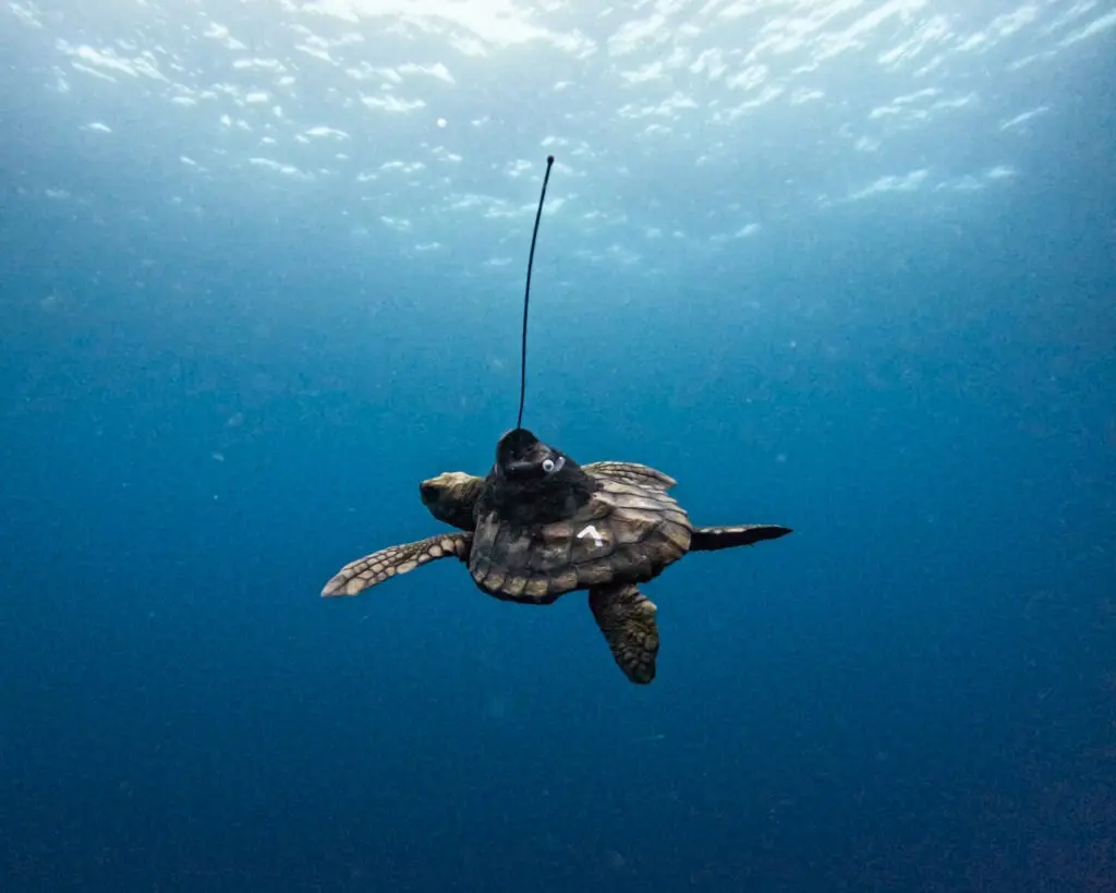
Now, a groundbreaking collaborative initiative is piercing through this shroud of scientific uncertainty. By outfitting rescued, rehabilitated, and released juvenile loggerhead sea turtles with state-of-the-art miniature satellite tags, marine biologists are finally mapping the secret odysseys of these resilient reptiles. Named after literary icons and local symbols of hope—such as Tolkien and Mpho—these young loggerheads are serving as aquatic ambassadors. Their remarkable trans-oceanic journeys are being documented in real-time, tracing their movements from South Africa’s vulnerable coastal ecosystems, through officially designated "Hope Spots," and deep into the open ocean.
This ambitious tracking project is the fruit of a powerful synergistic partnership between the Two Oceans Aquarium Turtle Conservation Centre, Upwell Turtles, and Dr. Sylvia Earle’s global marine conservation foundation, Mission Blue. By leveraging advanced geographic information systems (GIS) and cutting-edge telemetry, the collaborative StoryMap project—accessible publicly via ArcGIS—translates complex satellite data into an engaging, accessible, and scientifically rigorous narrative.
Beyond tracking individual animals, the initiative carries profound implications for international marine policy. The data collected is actively illuminating critical biological hotspots, shedding light on anthropogenic threats, and providing policymakers with the empirical evidence required to designate stronger, legally binding ocean protections. As climate change, industrial fishing, and plastic pollution continue to degrade marine ecosystems, this project offers a vital blueprint for bridging the gap between wildlife rehabilitation and large-scale ocean conservation.
Detailed Chronology: From Rescue to Pelagic Pioneer
To fully appreciate the significance of the telemetry data currently being beamed back from the open ocean, it is essential to trace the arduous trajectories of these animals. Their journeys do not begin on the pristine blue waters of the high seas; rather, they typically start in the harrowing crucible of stranding, rehabilitation, and medical intervention.
Phase One: The Rescue and Critical Care
Every year, thousands of juvenile loggerhead (Caretta caretta) and other marine turtle species hatch along the warm northern coasts of South Africa and southern Mozambique. Promptly upon entering the Indian Ocean currents, many of these fragile hatchlings are swept southward by the ferocious Agulhas Current. However, due to seasonal sea temperature drops, rough storm surges, and exhaustion, a significant number of these young turtles wash ashore along South Africa’s treacherous southern and western coasts. Suffering from severe hypothermia, dehydration, buoyancy disorders, and deep-seated injuries—often exacerbated by accidental ingestion of marine debris—these stranded animals face near-certain mortality without human intervention.
Enter the Two Oceans Aquarium Turtle Conservation Centre based in Cape Town, South Africa. Serving as a beacon of hope for stranded marine life, the facility operates a world-class intensive care unit dedicated to turtle rehabilitation. Here, veterinary teams administer aggressive fluid therapy, targeted antibiotic regimens, and specialized nutritional support. For patients like Tolkien and Mpho, rehabilitation is a painstaking, months-long process. It requires meticulous water temperature regulation, physical therapy to combat muscular atrophy, and surgical procedures to remove ingested plastics. Only once these juveniles regain optimal body condition, demonstrate natural foraging behaviors, and achieve a healthy weight threshold are they cleared for release.
Phase Two: High-Tech Telemetry and the Moment of Release
Rehabilitating a sea turtle is only half the battle; ensuring its survival upon reintegration into the wild requires continuous post-release monitoring. Before release, veterinary specialists carefully attach miniature satellite transmitters to the carapace (top shell) of each turtle using specialized, marine-grade epoxy. These low-profile tags are aerodynamically and hydrodynamically designed to minimize drag and avoid interfering with the animal’s natural swimming mechanics. Each time the turtle surfaces to breathe, the tag transmits its precise GPS coordinates to passing Argos or Iridium satellites, plotting a continuous vector of its journey.
The release sites are strategically chosen, typically within or adjacent to South Africa’s protected marine zones and internationally recognized Hope Spots—special areas scientifically identified as critical to the health of the ocean. As Tolkien, Mpho, and their cohort slip back into the cool, nutrient-rich waters of the Atlantic and Indian Ocean convergence zones, their satellite tags awaken, marking the official commencement of their tracking journey.
Phase Three: Navigating the Hope Spots and the Open Ocean
Once liberated, the tracking data reveals a fascinating narrative of navigation and survival. Initially, the juvenile loggerheads navigate through the intricate coastal ecosystems of South Africa, utilizing nearshore currents and localized upwellings to forage. As observed through the Mission Blue and Upwell Turtles StoryMap, these regions—designated as Hope Spots due to their unique biodiversity and ecological significance—act as critical staging grounds.
As the weeks transition into months, the telemetry data captures a monumental shift in behavior. The turtles venture away from the relative safety of the coastline, crossing the continental shelf and plunging into the pelagic expanse of the open ocean. Here, they encounter sweeping oceanic gyres, massive convergence fronts, and dynamic thermal boundaries. By following these currents, Tolkien, Mpho, and their peers are effectively rewriting our understanding of the "lost years," proving that these animals are not merely drifting passively at the mercy of the waves, but are actively engaging with complex oceanic systems to find food, evade predators, and grow into maturity.
Supporting Context & Metrics: The Science of the "Lost Years"
To contextualize the importance of the telemetry project, one must understand the biological vacuum it is designed to fill. In marine biology, the term "lost years" refers to the developmental phase spanning from the moment a hatchling enters the sea until it reappears in coastal foraging grounds several years later as a robust juvenile or sub-adult (often measuring 15 to 30 centimeters in straight carapace length).
[Hatching & Coastal Entry]
          │
          ▼
[Agulhas Current Transport]
          │
          ▼
[Stranding & Rehabilitation] (Two Oceans Aquarium)
          │
          ▼
[Satellite Tagging & Release] (Hope Spots)
          │
          ▼
[Pelagic Navigation / The "Lost Years" Mapped]
The Ecological Significance of Loggerheads
Loggerhead sea turtles are classified globally as vulnerable by the International Union for Conservation of Nature (IUCN). As apex predators and omnivores within marine food webs, they play a vital role in maintaining the health of benthic ecosystems by controlling populations of crabs, mollusks, and sea urchins. Their migratory patterns often span multiple national jurisdictions and international waters, making them true marine migratory species that require cross-border protection frameworks.
The Mechanics of Satellite Telemetry in Marine Conservation
The integration of satellite telemetry into marine biology has revolutionized the field. Unlike traditional flipper tags—which rely on physical recapture to yield data points (typically offering only a start and end location)—satellite tags provide a continuous temporal and spatial trajectory.
- Argos and GPS Precision: Modern marine tags utilize a combination of GPS receivers and the Argos satellite system. When a turtle surfaces, the tag acquires a GPS fix and transmits data packages, yielding spatial accuracies often down to a few meters.
- Sensor Integration: Beyond location data, advanced tags frequently incorporate depth sensors, temperature monitors, and accelerometers. This allows researchers to analyze dive profiles, determine how much time a turtle spends basking at the surface versus diving deep into the water column, and identify preferred thermal niches.
- Data Visualization via GIS: The partnership with Upwell Turtles and Mission Blue integrates this raw telemetry data into ArcGIS StoryMaps. By blending spatial science with multimedia storytelling, the project bridges the gap between insular scientific literature and public environmental literacy. Citizens, students, and policymakers can visually interact with the migration tracks, observing how oceanographic variables—such as sea surface temperature anomalies and surface currents—correlate with turtle movements.
Official Statements and Expert Perspectives
The collaborative nature of this initiative brings together world-renowned marine conservation organizations, each contributing specialized expertise to ensure the project’s success.
Dr. Sylvia Earle, legendary oceanographer and founder of Mission Blue, has repeatedly emphasized the urgent need to protect pelagic ecosystems and the migratory pathways of marine species. Reflecting on the significance of the turtle tracking initiative, Dr. Earle noted:
"The open ocean is often viewed as a vast, empty blue desert, but in reality, it is a bustling superhighway for marine life. By following the journeys of Tolkien and Mpho, we are granted an intimate window into the previously hidden lives of these magnificent creatures. These turtles are telling us an urgent story about ocean health, connectivity, and the absolute necessity of safeguarding our global Hope Spots from mounting anthropogenic pressures."
Echoing these sentiments, representatives from the Two Oceans Aquarium Turtle Conservation Centre highlighted the profound emotional and scientific bridge between local rehabilitation work and global ocean governance. A senior conservation spokesperson for the aquarium stated:
"Every turtle that comes through our doors represents a second chance—not just for the individual animal, but for our understanding of marine conservation as a whole. Rehabilitating a hypothermic, plastic-impacted loggerhead is an intensive medical challenge. However, seeing that same turtle fitted with a satellite tag, released into a South African Hope Spot, and tracked as it successfully navigates the open ocean is the ultimate validation of our work. This project proves that local rehabilitation efforts can yield globally significant scientific data."
Upwell Turtles, an organization dedicated to the conservation of sea turtles throughout their marine habitats, underscored the critical role of telemetry in identifying high-risk areas. Through their ongoing collaboration, Upwell has championed the use of cutting-edge technology to drive policy changes. Project directors emphasize that the data harvested from these juvenile loggerheads is instrumental in mapping cumulative human impacts—such as longline fishing bycatch, maritime traffic, and marine plastic convergence zones—thereby guiding international conservation bodies in establishing dynamic marine protected areas (MPAs) that adapt to shifting species distributions.
Future Outlook: Bridging Science, Policy, and Public Action
As the satellite tags continue to ping their signals across the globe, transmitting the evolving coordinates of Tolkien, Mpho, and their companions, the horizon of marine conservation is shifting. The insights generated by this collaborative StoryMap are laying the groundwork for a new era of proactive, data-driven ocean management.
Implications for Marine Protected Areas (MPAs)
Historically, marine protected areas have been static, bounded by fixed geographical coordinates drawn on a map. However, highly migratory species like loggerhead sea turtles do not recognize political boundaries or static lines. The continuous tracking data provided by Upwell Turtles and the Two Oceans Aquarium highlights the necessity of dynamic ocean management (DOM)—a governance framework where protective regulations move and adapt in real-time based on environmental conditions and animal telemetry. By identifying precise pelagic corridors utilized during the "lost years," conservationists can advocate for seasonal or mobile protections in international waters where industrial fishing pressures are highest.
Mitigating Anthropogenic Threats
The journey through the open ocean is fraught with peril. Climate change is rapidly altering sea surface temperatures and disrupting ocean currents, potentially throwing evolutionary migratory cues out of alignment. Furthermore, the proliferation of microplastics and macro-debris in oceanic convergence zones poses an ongoing, lethal threat to juvenile turtles that mistake floating plastics for food. The data collected from this project will assist researchers in mapping plastic accumulation zones against turtle migration routes, providing irrefutable empirical evidence to bolster global efforts targeting plastic pollution at its source.
Empowering Global Environmental Stewardship
Perhaps one of the most powerful outcomes of the Mission Blue, Upwell, and Two Oceans Aquarium collaboration is its democratization of science. By hosting the tracking data on an open-access ArcGIS StoryMap platform, the initiative invites the global public to become active participants in marine conservation. Anyone with an internet connection can follow the day-to-day progress of individual turtles, fostering a deep emotional connection with marine wildlife that transcends traditional academic boundaries.
Conclusion
The remarkable odysseys of Tolkien and Mpho represent far more than just a fascinating biological study; they are a testament to resilience, recovery, and the power of collaborative science. By lifting the veil on the "lost years," these young loggerhead sea turtles are charting a course toward a more enlightened relationship with our blue planet. Their journeys remind us that while the open ocean is vast and perilous, it is also interconnected—and that every effort invested in healing a single stranded turtle ripples outward, ultimately helping to secure the health and vitality of the global ocean for generations to come.
To follow the journey of Tolkien, Mpho, and other juvenile loggerheads, and to discover what these remarkable turtles are teaching us about open ocean conservation, visit the official ArcGIS StoryMap.