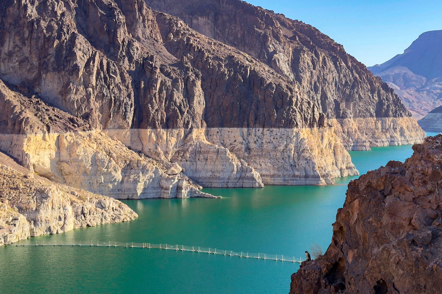
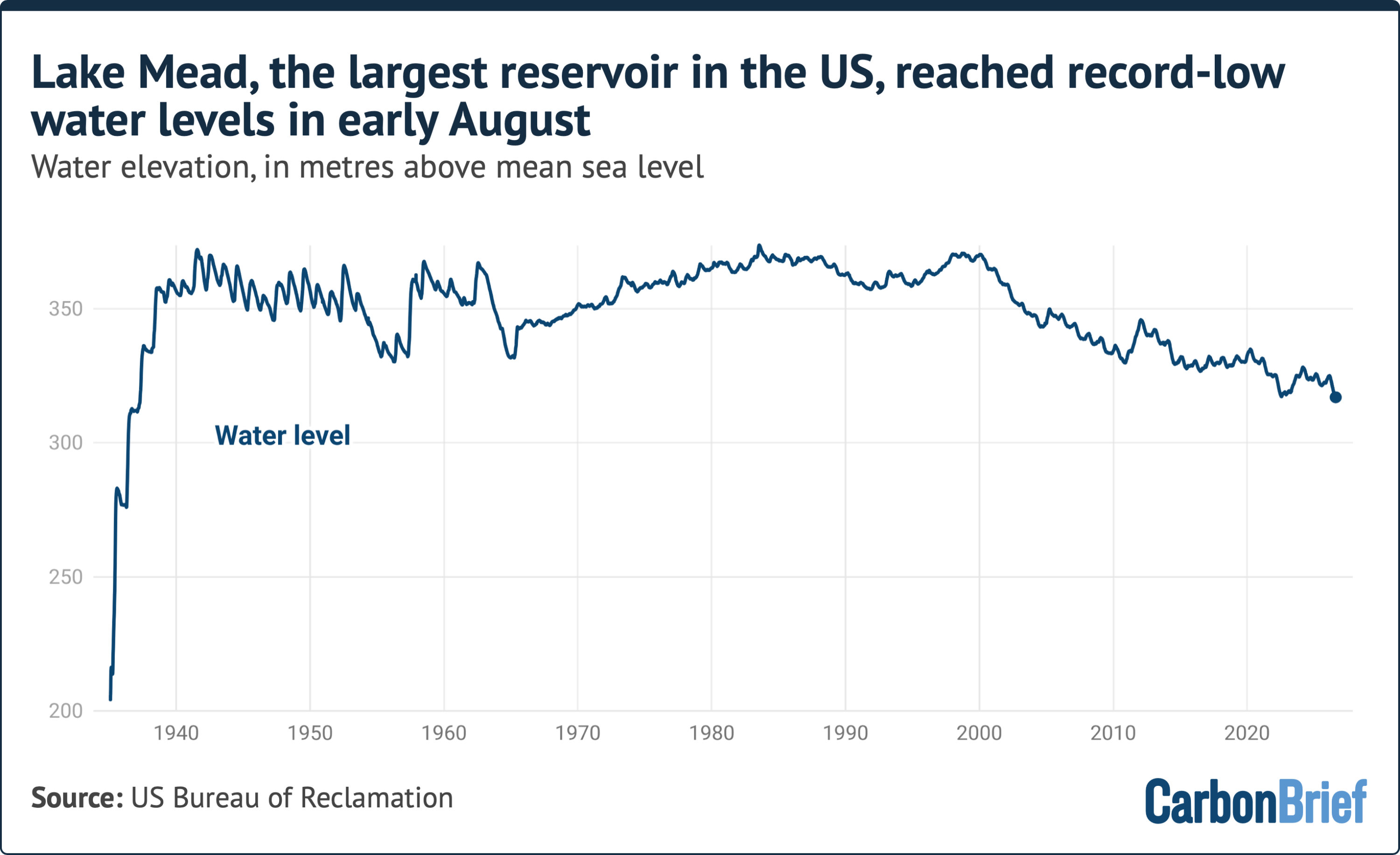
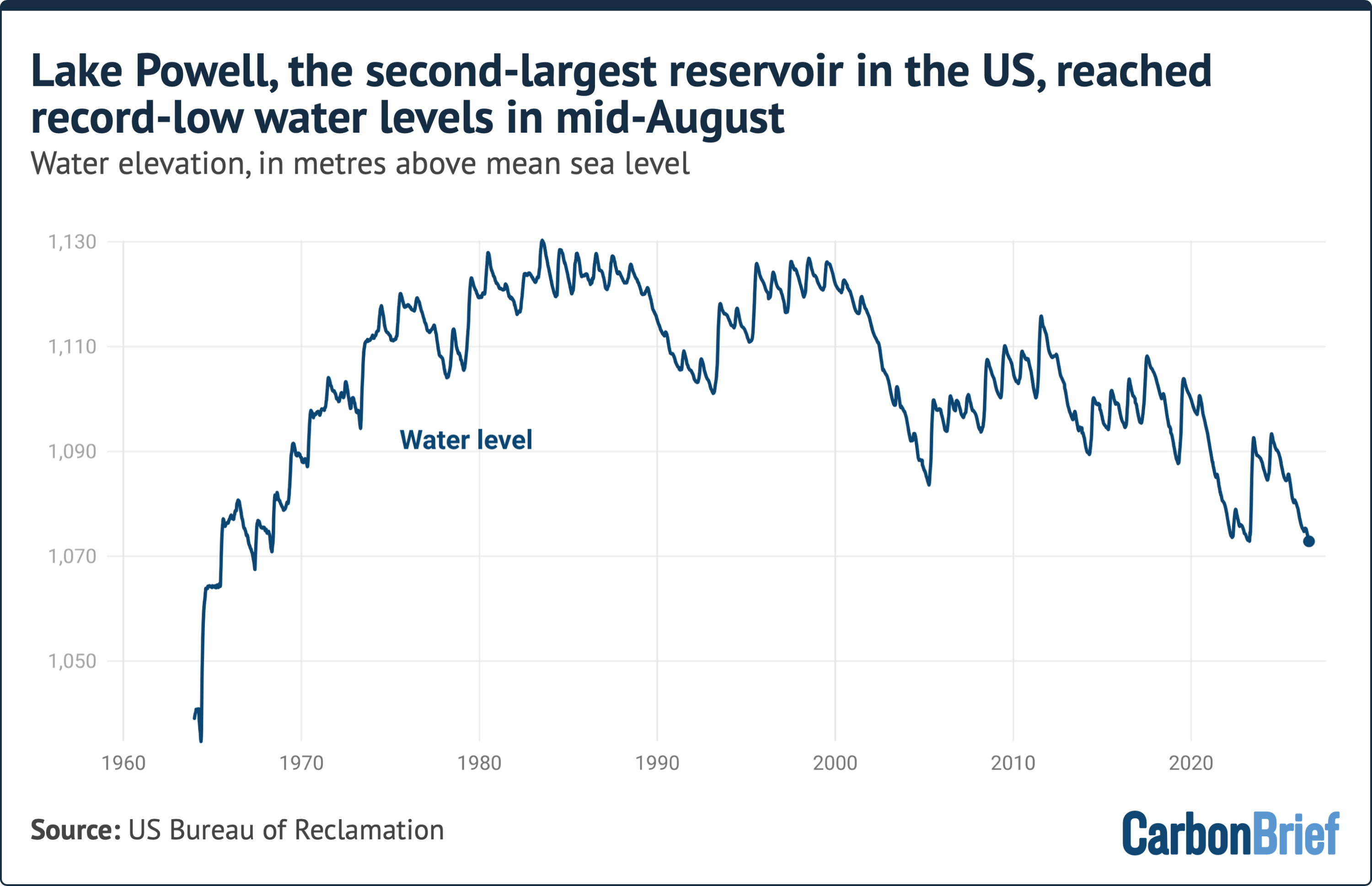
The American Southwest is facing an existential hydrological reckoning as its two primary water storage arteries, Lake Mead and Lake Powell, have simultaneously breached historic, record-low elevation thresholds. On August 7, Lake Mead—the nation’s largest artificial reservoir by volume—dropped to an all-time low of 317.11 meters above mean sea level. Just eight days later, on August 15, Lake Powell—the country’s second-largest reservoir—followed suit, sinking to its own unprecedented minimum elevation of 1,072.87 meters.
Both impoundments sit along the mainstem of the Colorado River, a critical water supply network that sustains approximately 40 million people across seven U.S. states and northern Mexico. In addition to supplying municipal water to major metropolitan centers such as Los Angeles, Phoenix, Las Vegas, and San Diego, the river irrigates roughly 5.5 million acres (22,258 square kilometers) of agricultural land that produces a vast majority of North America’s winter vegetables.
According to hydrological experts and climate scientists, the dual record lows are not an anomaly, but rather the cumulative result of a quarter-century "megadrought" exacerbated by anthropogenic climate change, rapid regional population growth, and systemic over-allocation rooted in century-old legal frameworks. With reservoir depletion expected to continue through next spring, state and federal authorities are confronting severe operational threats, including the risk of reaching "dead pool" conditions where water can no longer pass through dam turbines to generate hydroelectricity or service downstream communities.
Detailed Chronology: From Abundance to Structural Deficit
COLORADO RIVER RESERVOIR ELEVATION HISTORICAL TIMELINE
========================================================================================
1935          1963          1980s         2000          Mid-August
Hoover Dam    Glen Canyon   Peak Reservoir Megadrought   Simultaneous Record Lows
Completed     Dam Completed Levels        Begins        Mead: 317.11m | Powell: 1,072.87m
  |-------------|-------------|-------------|---------------------|
The infrastructure underpinning the modern American West was designed during an unusually wet climate regime in the early-to-mid 20th century. Lake Mead began filling in 1935 following the completion of the Hoover Dam, designed with a maximum "full pool" elevation of 347.60 meters. Three decades later, the impoundment of Lake Powell behind the Glen Canyon Dam established a secondary storage bank upstream, featuring a full pool capacity elevation of 1,127.76 meters.
At full capacity, the combined storage of Lakes Mead and Powell totals 68 cubic kilometers of water—an immense reserve capable of supplying all household water consumption in the contiguous United States for nearly 1.5 years. Throughout the mid-1980s, high winter snowpacks repeatedly filled both reservoirs to near-capacity, instilling a sense of water security across the Southwest.
However, the turn of the 21st century marked a fundamental shift in the basin’s hydrology:
2000: The onset of a multi-decade Southwestern "megadrought," later identified by climate scientists as the driest 22-year period in the region in over 1,200 years.
2000–2020: Continuous net drawdowns. Upper Basin streamflows plummeted, and annual water withdrawals consistently exceeded natural inflows, creating a persistent structural deficit.
August 7: Lake Mead breaches its previous low-water threshold, dropping to 317.11 meters above mean sea level.
August 15: Lake Powell reaches a new record low of 1,072.87 meters above mean sea level.
Hydrologists emphasize that these summer lows mark the beginning—not the end—of a critical drawdown window. The water levels in both lakes will continue a downward trajectory through the autumn and winter months. Substantial recovery cannot occur until the spring snowmelt begins in the high-elevation headwaters of Colorado, Wyoming, and Utah, typically around early April.
Supporting Context & Hydrological Metrics
The collapse of reservoir storage is driven by a complex interplay of physical climate mechanics, demographic shifts, and agricultural demands.
COLORADO RIVER BASIN WATER METRICS AT A GLANCE
+------------------------------------+------------------------------------------+
| Metric                             | Value / Detail                           |
+------------------------------------+------------------------------------------+
| Municipal Reliance                 | ~40 Million People                       |
| Irrigated Farmland                 | 5.5 Million Acres (22,258 sq km)         |
| Combined Full Capacity             | 68 Cubic Kilometers                      |
| Population Growth (1992–Present)   | +15 Million (+60%)                       |
| Upper Basin Flow Reduction (1900+) | ~20% Decrease                            |
| Climate Change Contribution        | ~50% of Flow Reduction                   |
+------------------------------------+------------------------------------------+
1. The Climatic Engine: Aridification and Soil Absorption
Since the early 20th century, the volume of water flowing through the Upper Colorado River Basin has declined by approximately 20%. Peer-reviewed atmospheric research indicates that at least half of this reduction is directly attributable to human-induced climate change.
Rising regional temperatures create a compounding hydrological penalty:
Thermal Evapotranspiration: Warmer air absorbs significantly more moisture from surface reservoirs, rivers, and vegetation.
Snowpack Inefficiency: Higher temperatures cause a greater fraction of winter precipitation to fall as rain rather than snow, leading to premature runoff.
Desiccated Soils: Unseasonably hot springs dry out mountain soils. When the winter snowpack melts, the dry earth acts as a sponge, absorbing water before it can reach stream channels and flow into Lake Powell.
Scientific attribution studies on the 2000–2018 drought period reveal that anthropogenic warming accounted for nearly 47% of the drought’s severity, transforming a natural dry spell into an unprecedented crisis of aridity.
HYDROLOGICAL DISCONNECT IN UPPER BASIN RUNOFF
[Winter Snowpack] ---> [Warmer Temperatures] ---> [Desiccated Soils / Evapotranspiration]
                                                          |
                                                          v
                                             [Reduced Runoff to Reservoirs]
2. Demographic and Agricultural Demand
While the natural water supply has diminished, structural demand has grown significantly.
Since 1992, the number of individuals relying on the Colorado River for municipal water has risen by 15 million—a 60% increase. Dense urban corridors, including Phoenix, Las Vegas, Denver, and Southern California, have expanded rapidly, adding millions of residential connections to the grid.
Concurrently, the basin supports an intensive agricultural system across California, Arizona, Colorado, and Utah. Over 5.5 million acres of land depend on Colorado River diversions to produce alfalfa, hay, winter vegetables, citrus, and cotton. Alfalfa and forage crops, grown primarily to feed domestic and export livestock, consume a major portion of the river’s total diverted volume, highlighting the friction between agricultural water rights and municipal survival.
Official Statements and Institutional Policy Dynamics
The crisis has exposed the operational limitations of the legal structures governing the river, collectively known as the "Law of the River." Chief among these is the 1922 Colorado River Compact, which allocated paper water rights that exceeded the river’s long-term average flow—even before taking climate change into account.
Dr. Jack Schmidt, a senior research scientist at Utah State University’s Center for Colorado River Studies, highlights the systemic disconnect between climate realities and policy mechanisms:
"The ultimate cause is a warming climate, a warming planet and a pretty clear correlation between warming conditions and decreased runoff in the Colorado River Basin.
The proximate cause is that in this messy democratic republic of ours, big policy decisions that match the variability of the climate occur painfully slowly—with intense political negotiations—and only incrementally."
Addressing the reality of the coming dry season, Dr. Schmidt emphasized the uncertainty facing water managers:
"The big dilemma of the moment is that we’re only in the middle of August, and we have no assurance of what the coming winter will be. The only thing we can be sure of is that we will be depleting overall total basin reservoir storage from now until, roughly, early April."
In response to the operational threat, the U.S. Bureau of Reclamation—the federal agency responsible for managing water infrastructure across the American West—released a comprehensive Draft Environmental Impact Statement (EIS) on July 31. The document evaluates proposed operational strategies for Lakes Powell and Mead post-2026, when current operating guidelines expire.
While the preliminary filings grant federal managers broader administrative flexibility to enforce emergency delivery cuts across basin states, experts caution that regulatory tools alone cannot create water where none exists. As Dr. Schmidt observed regarding the EIS projections:
"They acknowledge it won’t work if we just stay critically dry, and of course every climate model for the 21st century, especially with a continually warming planet, says that that’s exactly what’s going to happen."
Future Outlook: The Structural Road to Post-2026
The simultaneous drop of Lake Mead and Lake Powell to historic lows places the Southwest at a structural crossroads. Water managers are forced to plan for unprecedented hydrological scenarios:
RESERVOIR THRESHOLD RISKS
+-------------------------+-----------------------------------------------------------+
| Elevation Threshold     | Operational / Ecological Impact                           |
+-------------------------+-----------------------------------------------------------+
| Minimum Power Pool      | Hydroelectric turbines stall; grid power loss across west |
| Dead Pool               | Water drops below intake penstocks; zero downstream flow  |
| Structural Re-design    | Required physical dam bypass modifications                |
+-------------------------+-----------------------------------------------------------+
1. Hydropower Vulnerability and "Dead Pool" Risk
If Lake Powell falls below its "minimum power pool" elevation of 1,063 meters (3,490 feet), Glen Canyon Dam will lose the hydraulic pressure required to spin its hydroelectric turbines, cutting off renewable electricity for millions of customers across five states.
If water levels fall further to "dead pool" elevation (1,027 meters / 3,370 feet), water can no longer flow through the dam by gravity, severing the connection between the Upper and Lower Basins and disrupting water delivery to Lake Mead, Nevada, Arizona, California, and Mexico.
2. Mandatory Interstate Cutbacks
Under current operational agreements and anticipated post-2026 guidelines, Lower Basin states (Arizona, Nevada, and California) face mandatory reductions in their annual allocations. Arizona and Nevada have already absorbed voluntary and enforced cutbacks, while California—holding senior water rights—is facing pressure to accept permanent reductions.
3. Long-term Systemic Adaptation
To prevent a complete system collapse, water agencies across the Southwest are pursuing broad structural adaptations:
Large-Scale Agricultural Fallowing: Compensating farmers to leave fields unplanted or shift to low-water crops.
Urban Water Recycling: Multi-billion-dollar investments in advanced water purification and indirect potable reuse facilities in Southern California and Arizona.
Tighter Turf Mandates: Banning non-functional grass across municipal zones, a strategy pioneered by Southern Nevada to reduce per-capita water consumption.
As the Colorado River Basin heads into another uncertain winter, the record lows at Lakes Mead and Powell signal that the era of relying on historical hydrological averages is over. Policy makers, agricultural producers, and urban planners must now adapt to a permanently drier baseline in the American West.